River Ouse, Yorkshire
| River Ouse | |
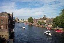
 The River Ouse in York | |
| Country | England |
|---|---|
| County | Yorkshire |
| Source | River Ure |
| - location | Cuddy Shaw Reach, near Linton-on-Ouse |
| - elevation | 10 m (33 ft) |
| - coordinates | GB-ENG 54°2′4″N 1°16′30″W / 54.03444°N 1.27500°W |
| Mouth | Humber Estuary |
| - location | Trent Falls |
| - elevation | 0 m (0 ft) |
| - coordinates | GB-ENG 53°42′8″N 0°41′46″W / 53.70222°N 0.69611°WCoordinates: GB-ENG 53°42′8″N 0°41′46″W / 53.70222°N 0.69611°W |
| Length | 84 km (52 mi) |
| Basin | 10,704 km2 (4,133 sq mi) |
| Discharge | for Skelton |
| - average | 51.2 m3/s (1,808 cu ft/s) |
 River Ouse catchment | |
| Wikimedia Commons: River Ouse, Yorkshire | |
River Ouse, Yorkshire | ||||||||||||||||||||||||||||||||||||||||||||||||||||||||||||||||||||||||||||||||||||||||||||||||||||||||||||||||||||||||||||||||||||||||||||||||||||||||||||||||||||||||||||||||||||||||||||||||||||||||||||||||||||||||||||||||||||||||||||||||||||||||||||||||||||||||||||||||||
|---|---|---|---|---|---|---|---|---|---|---|---|---|---|---|---|---|---|---|---|---|---|---|---|---|---|---|---|---|---|---|---|---|---|---|---|---|---|---|---|---|---|---|---|---|---|---|---|---|---|---|---|---|---|---|---|---|---|---|---|---|---|---|---|---|---|---|---|---|---|---|---|---|---|---|---|---|---|---|---|---|---|---|---|---|---|---|---|---|---|---|---|---|---|---|---|---|---|---|---|---|---|---|---|---|---|---|---|---|---|---|---|---|---|---|---|---|---|---|---|---|---|---|---|---|---|---|---|---|---|---|---|---|---|---|---|---|---|---|---|---|---|---|---|---|---|---|---|---|---|---|---|---|---|---|---|---|---|---|---|---|---|---|---|---|---|---|---|---|---|---|---|---|---|---|---|---|---|---|---|---|---|---|---|---|---|---|---|---|---|---|---|---|---|---|---|---|---|---|---|---|---|---|---|---|---|---|---|---|---|---|---|---|---|---|---|---|---|---|---|---|---|---|---|---|---|---|---|---|---|---|---|---|---|---|---|---|---|---|---|---|---|---|---|---|---|---|---|---|---|---|---|---|---|---|---|---|---|---|---|---|---|---|---|---|---|---|---|---|---|---|---|---|---|---|
Legend
| ||||||||||||||||||||||||||||||||||||||||||||||||||||||||||||||||||||||||||||||||||||||||||||||||||||||||||||||||||||||||||||||||||||||||||||||||||||||||||||||||||||||||||||||||||||||||||||||||||||||||||||||||||||||||||||||||||||||||||||||||||||||||||||||||||||||||||||||||||
The River Ouse (/ˈuːz/ OOZ) is a river in North Yorkshire, England. Hydrologically the river is a continuation of the River Ure, and the combined length of the River Ure and River Ouse makes it, at 129 miles (208 km), the sixth longest river of the United Kingdom and (including the Ure) the longest to flow entirely in one county. The length of the Ouse alone is about 52 miles (84 km).
The river is formed at the confluence of the River Ure and the much smaller Ouse Gill Beck at Cuddy Shaw Reach near Linton-on-Ouse, about six miles downstream of the confluence of the River Swale with the River Ure. It then flows through the city of York and the towns of Selby and Goole before joining with the River Trent at Trent Falls, near the village of Faxfleet, to form the Humber Estuary.
The Ouse's system of tributaries (which includes the Derwent, Aire, Don, Wharfe, Rother, Nidd, Swale, Ure, and Foss) drains a large upland area of northern England, including much of the Yorkshire Dales and North York Moors.
The Ouse valley is a wide, flat plain; heavy rainfall in the river's catchment area can bring severe flooding to nearby settlements. In recent years both York and Selby, and villages in between, have been very badly hit.
Sources
The traditional source of the Ouse is in the village of Great Ouseburn, and is marked by a stone column reading "OUSE RIVER HEAD... OUSEGILL SPRING Ft. YORK 13miles BOROUGHBRIDGE 4miles".[1] The site is 38 yards (35 m) from the present course of Ouse Gill Beck, a small stream earlier known as Usekeld Beck, meaning "Spring or source of the Ouse" (from Old Norse kelda "spring").[2]
The start of the Ouse is now considered to be the point where Ouse Gill Beck joins the River Ure, 1.6 miles (2.5 km) south east of Great Ouseburn.
Etymology
The origin of the name is uncertain. The name was first recorded in about 780 as Usa. It has been speculated that the name is of Brythonic-Celtic origin, from an assumed word udso-, assumed to be derived from the Indo-European root wed-, meaning "water".[3] Other sources prefer a Proto-Celtic.[4]
It has been suggested that the Ouse was once known as the 'Ure', but there seems to be no supporting evidence for this claim. The suggestion that the name derives from the Celtic name of the Ure, assumed to be Isurā from the Roman name for Aldborough, and over time evolved into Isis and finally the Saxon Ouse, would go some way to explaining how the little tributary Ouse Gill Beck usurps the name of the much larger River Ure.[5] However the form Ouse is little changed from the eighth century.
The York district was settled by Norwegian and Danish people, so parts of the place names could be old Norse. Referring to the etymological dictionary "Etymologisk ordbog", ISBN 82-905-2016-6 dealing with the common Danish and Norwegian languages - roots of words and the original meaning: Os - the mouth of a river. The old Norse wording oss, gradation form ouso.
Navigation
The Ouse is navigable throughout its length. Seagoing vessels use the river as far as Goole, where there is an inland port and access to the Aire and Calder Navigation. At Selby there is access to the Selby Canal. The river is tidal up to Naburn; the resultant tidal bore is known locally as "the Aegir".
At Naburn there is a weir with locks, so that boats of 150 feet (45.7 m) length and 15 feet (4.6 m) beam can reach York.[6][7] Above York there is another weir with locks at Linton-on-Ouse, which allows boats of 66 feet (20 m) length to proceed to the River Ure Navigation.[8]
The navigation authority is Associated British Ports from Trent Falls to Goole railway swing bridge at Skelton, and the Canal & River Trust upstream from there.[8]
In the 18th and 19th centuries there was considerable commercial traffic on the river, mainly from Selby, which then had a custom house, downstream. After the 1826 opening of the Aire and Calder Navigation, most traffic became concentrated on the port of Goole. This continues, although the coal trade which formed the backbone of the river trade has ceased.
Settlements

(From the confluence of Swale and Ure)
- Lower Dunsforth
- Aldwark
- Linton-on-Ouse
- Newton-on-Ouse
- Nun Monkton
- Beningbrough
- Overton
- Nether Poppleton
- York
- South Bank
- Fulford
- Bishopthorpe
- Naburn
- Acaster Malbis
- Acaster Selby
- Cawood
- Kelfield
- Riccall
- Barlby
- Selby
- Hemingbrough
- Barmby on the Marsh
- Booth
- Hook
- Skelton
- Goole
- Swinefleet
- Saltmarshe
- Reedness
- Little Reedness
- Whitgift
- Blacktoft
- Ousefleet
- Faxfleet
(Joins Trent at Trent Falls to form Humber)[9]
See also
- Blacktoft Sands RSPB reserve
- Bridges over the Ouse
- Rivers of the United Kingdom
- York City Rowing Club
References
- ↑ "Great Ouseburn Parish Website". Retrieved 31 August 2014.
- ↑ Smith, A.H. (1961). The Place-names of the West Riding of Yorkshire. 5. Cambridge University Press. p. 5.
- ↑ Smith, A.H. (1962). The Place-names of the West Riding of Yorkshire. 7. Cambridge University Press. pp. 133–134.
- ↑ Watts, Victor, ed. (2010). "Ouse". The Cambridge Dictionary of English Place-Names. Cambridge University Press. p. 456. ISBN 978 0 521 16855 7.
- ↑ Ekwall, E. English River Names (Oxford University Press: 1928). Waite, Alice. Exploring the Yorkshire Ouse (Countryside Productions: 1988)
- ↑ Szyca, G. (2011). Comprehensive Methods of the Minimum Safe Under Keel Clearance Valuation to the Restricted Tidal Waters. In: Weintrit, A. and Neumann, T. (Eds.) Methods and Algorithms in Navigation: Marine Navigation and Safety of Sea Transportation. London: Taylor and Francis Group, p. 51–56.
- ↑ Broadhead, I.E. (1982). Portrait of the Yorkshire Ouse. London: Hale, p. 126.
- 1 2 "Yorkshire Ouse". Waterways Association. Retrieved 2 September 2014.
- ↑ "Yorkshire Ouse". www.waterways.org.uk. Retrieved 5 November 2015.
External links
| Wikimedia Commons has media related to River Ouse, Yorkshire. |