Thirsk
| Thirsk | |
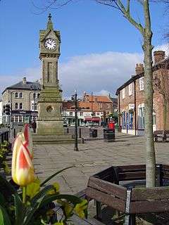 Clock in town centre |
|
 Thirsk |
|
| Population | 4,998 (2011 census)[1] |
|---|---|
| OS grid reference | SE429820 |
| – London | 227 miles (365 km) |
| Civil parish | Thirsk |
| District | Hambleton |
| Shire county | North Yorkshire |
| Region | Yorkshire and the Humber |
| Country | England |
| Sovereign state | United Kingdom |
| Post town | THIRSK |
| Postcode district | YO7 |
| Dialling code | 01845 |
| Police | North Yorkshire |
| Fire | North Yorkshire |
| Ambulance | Yorkshire |
| EU Parliament | Yorkshire and the Humber |
| UK Parliament | Thirsk and Malton |
| Website | http://www.thirsk.org.uk/ |
Coordinates: 54°13′58″N 1°20′31″W / 54.232731°N 1.342050°W
Thirsk is a small market town and civil parish in the Hambleton district of North Yorkshire, England. Historically part of the North Riding of Yorkshire, it is 8 miles (13 km) south-south east of the county town of Northallerton.
According to the 2011 UK Census, the population was 4,998. Thirsk is a popular tourist destination close to the Yorkshire Dales and the North York Moors. It has a variety of small and medium-sized businesses. It was the home of author James Herriot and birthplace of Thomas Lord, after whom Lord's Cricket Ground is named. Thirsk racecourse is on the western edge of the town.
History
Local archeological finds indicate there was a settlement here around 500–600 BC.[2] The town is mentioned twice in the Domesday Book as Tresche, in the Yarlestre hundred. At the time of the Norman invasion the manor was split between Orm and Thor, local Saxon landowners. Afterwards the manor was split between Hugh, son of Baldric and the Crown.[3] Most of the land was granted thereafter to Robert de Mowbray, after whom the surrounding vale is named.[4][5]
By 1145, what is now Old Thirsk was known as a borough, whilst the remaining land in the parish was subject to manorial rights. The manor continued to be in the possession of the Mowbrays, despite several claims, until the death of the 16th Lord Mowbray in 1476. With no direct succession, it passed to the daughter of Thomas de Mowbray, 1st Duke of Norfolk, who had married into the Berkeley family. Her son, William de Berkeley, 1st Marquess of Berkeley, then inherited the manor on her death. It remained with this family until 1723 when it was sold to Ralph Bell of Sowerby. It remained in the Bell family into the 20th century.[4][5]
The name is derived from the Viking (Old Norse) word þresk meaning fen or lake.[6][7]
Political history
The Mowbrays built a castle on the north side of present-day Castlegate. It is not mentioned in the Domesday Book and an exact date is not recorded but by 1176 the castle was completely destroyed after the uprising against Henry II. The Mowbrays then built a manor house on the site but this was later destroyed by the Scots in 1322.[4][5]
After the War of the Roses, Henry VII raised taxes that caused uprisings in the north. This led to the murder of the Henry Percy, 4th Earl of Northumberland, allegedly on The Little Green, when he was sent to collect the taxes. However, other evidence points to the murder occurring in nearby South Kilvington[8]
Industrial history
A 1767 Act of Parliament[9] provisioned for the building of a navigable waterway to the town from the River Swale along Cod Beck. The project (to deepen the channel, straighten part of its course, and build locks and a wharf) ran out of funds and was never completed, although remains of the wharf and a lock can be seen near Lock Bridge.[4][10]
The Thirsk Poor Law Union was formed in 1837 and covered a large part of the North Riding of Yorkshire. A workhouse was erected in Sutton Road in 1838.[5]

A rail crash occurred at Manor House signal box on 2 November 1892, on the North Eastern Railway about 3 miles (4.8 km) north of Thirsk railway station, when an express train collided with the back of a goods train, both heading south in fog. There were ten deaths and forty-three injured.[11]
A rail crash occurred on 31 July 1967, at Thirsk on the British Rail East Coast Main Line. An express train travelling north collided with a derailed freight train on the same line. There were seven deaths and forty-five injured.[12]
Social history
Thirsk was home to the veterinary surgeon and author James Herriot (pen name of James Alfred Wight, OBE, FRCVS).[13] Thirsk was referred to as Darrowby in the semi-autobiographical books about a vet's life in the Yorkshire Dales. Wight and his business partner Donald Sinclair (Siegfried Farnon in the books) established their veterinary practice at 23 Kirkgate which now houses The World of James Herriot museum, dedicated to Herriot's life and works.[14]
Governance
Thirsk is in the Thirsk and Malton Parliamentary constituency since its creation for the 2010 general election, before this it was in the Vale of York constituency. At the 2010 UK general election, Anne McIntosh was returned as the constituency's Member of Parliament. Representing the Conservative Party, she won the seat with 52.9% of the vote from a turnout of 50% of the eligible electorate.[15]
The town was a parliamentary borough that had representation in 1295 and then from 1547 to 1885. For the majority of the latter period, it was represented by two members until 1882 when it was reduced to one member.[16]
The constituency of Thirsk and Malton was originally created for the 1885 General Elections by the Redistribution of Seats Act of 1885 and existed until 1983. During that period it returned six Conservative party members to parliament, which included one by-election in 1915.[17]
It gives its name to the local district ward of Hambleton District Council and to the local electoral division of North Yorkshire County Council. The town returns one Councillor to the County Council and three Councillors to the District Council.[18] The population of this ward at the 2011 Census was 5,988.[19]
The Civil Parish of Thirsk was created by the Local Government Act 1894. The Local Government Act 1972 afforded Parish Councils the opportunity to change titles. Thirsk renamed itself a Town Council. In so doing, the Chairman was also renamed as Mayor. The council is represented by eleven Councillors.[18][20]
Geography

The town lies in the Vale of Mowbray, 23 miles (37 km) north of York. Cod Beck runs through the centre of Thirsk. The area to the east of the river is called Old Thirsk.
Thirsk is surrounded by a number of other villages having names of Danish origin (the -by suffix meaning village or farmstead). Examples are Thirlby, Boltby, Borrowby and Sowerby. The village of Sowerby merges into Thirsk but they are separate parishes.[21]
The parish boundary between Thirsk and Sowerby runs east from the railway station behind the buildings along the A61 as far as Millbank Court from where it runs through the middle of the road. It continues to divide the highway through Westgate and Castlegate as far as the junction with Chapel Street down which it also runs dividing the street in two. It then crosses Cod Beck and runs along Moor Lane Stell before ending at Barbeck Bridge. Thirsk Industrial Estate lies outside the parish boundary. Bordering parishes include South Kilvington, Thornborough, Thornton-le-Moor, Newsham, Sandhutton and Carlton Miniott (also the location of Thirsk railway station).[21]
Demography
The 1881 UK Census recorded the population of the Parish as 3,337.[5] The parish had a population of 4,703 according to the 2001 Census.[22] The 2011 UK Census recorded the population as 4,998, an increase of 33% over the past 120 years, with a density of 0.7 people per hectare. Of the total population, 48.9% were male and 51.1% were female. The ethnic make up of the town was 94.3% White British, 3.8% Other White, 0.9% Asian British and 1.0% Black/Mixed and other Ethnic Groups. The religious composition of the town was 72.6% Christian, 26.6% None or no religion stated, 0.3% Muslim, 0.2% Buddhist, 0.1% Hindu, 0.1% Jewish and 0.0% Sikh.[23]
Economy
Thirsk is built around a large medieval market square, which still hosts an open-air market each Monday and Saturday. The market was established in 1145 and is the focal point for local farmers, traders and visitors. The town was once known for its leather tanning and saddlery trade, but this was replaced in the 19th century by the production of farming implements. This was aided by the establishment of the Mechanics Institute in 1848.[5]
The modern economy is based on hospitality, tourism, public administration, finance, manufacturing, construction, agriculture, small industrial, retail and service businesses.[24] It is home to online retailer VetUK.[25] Thirsk also has a livestock auction mart on a large site at Blakey Lane on the A19, south-east of the town.
Culture and community
Thirsk has a museum with exhibits from across the whole history of the town. It is located in the house in which Thomas Lord was born.[26] The adjoining village of Sowerby provides the town with its hospital, cinema, town hall building and swimming pool.
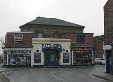
The Ritz Cinema on Westgate, Sowerby is a small 200 seat (100 stalls, 100 balcony) cinema run by volunteers. It dates back to 1912 and is probably one of Britain's oldest operating cinemas.[27] It shows in a period setting most of the current films and is run for residents and visitors to Thirsk and the local villages by a team of volunteers. In March 2012, the Ritz installed Digital projection equipment, purchased under a Digital Print Scheme through the Cinema Exhibitors' Association (CEA).
Arts charity Rural Arts,[28] is based at The Courthouse on Westgate. Running since 1992, it has a wide range of services including an award winning cafe, an art gallery, a workshop where visiting artists can run workshops, and meeting rooms which can be booked. It also works with professional companies through its ON Tour scheme. Running since 1999, this is a rural touring scheme that gets professional, high quality performance into the rural areas of North Yorkshire.
Thirsk Hall in Kirkgate is a grade II* listed 3-storey town house built in 1720 and extended in 1770 by York architect John Carr.[29]
The market square adjacent to the clock tower was featured in the artwork to Pulps 1995 album "Different Class".
Transport
The station is 22.25 miles (36 km) north of York on the East Coast Main Line. The station is about 1.5 miles (2 km) outside the town centre and is actually on the edge of the village of Carlton Miniott.
There are four tracks, but only the outer two have platforms. From satellite imagery it can look as if there are platforms on the inner two tracks, but examination on the ground shows this not to be true. The railway station is operated by TransPennine Express. Other train services are provided by the open-access operator Grand Central.
Local bus services to and from York, Ripon and Northallerton and nearby villages and long distance National Express Coaches call at the bus stop in the market place.
The main road running through the town is the A61, connecting Thirsk to Ripon. The A19 road now passes Thirsk to the east of the town, after a bypass was built in 1972. The former route of the A19 through the town is the A61 to the north to South Kilvington and the A170 to the south at the junction where the A19 joins the original route to the south.
Education
The town has one primary school, Thirsk Community Primary, the others being in adjoining Sowerby. It is within the catchment area of Thirsk School and Sixth Form College for secondary education. The current primary school was opened in 1979 with an extension added in 1991 to house extra classrooms, nursery section and medical facilities. Due to rises in the school population, some temporary build classrooms have also been erected on site.[30] It is a mixed gender school catering for pupils between the ages of 3 and 11. It has a student capacity of 315 and as of 2013 was at 90.5% of that.[31]
Religion

There is a 15th-century church dedicated to St Mary. The church is a Grade I Listed building.[32] Before this building there had been smaller chapels erected in the town dedicated to St James, St Giles and St Nicholas.[5]
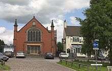
There is a Friends Meeting House in Kirkgate that has been there since at least 1799. There is a Wesleyan Chapel in St James' Green that was built in 1861. The Roman Catholic Church dedicated to All Saints was built in 1867 in Castlegate. The Primitive Methodists and the Congregationalists also used to have places of worship in the town.[5]
Sport
Thirsk Racecourse is a thoroughbred horse racing venue consisting of a left handed oval of about one mile and two furlongs. The present course opened in 1923, but racing had taken place on the old course over 200 years earlier. The racecourse serves flat racing in the spring and summer months.[33]
Thirsk Cricket Club was founded in 1851 and play in the middle of the local racecourse. The club was a founder member of the York & District League in which they still compete.[34] Also located at the facilities on the racecourse are Thirsk Hockey Club, who have been affiliated to the Yorkshire Hockey Association since 1923. Until the local Secondary School laid a floodlit artificial sports pitch, the club played on grass pitches that formed the out field of the Cricket Club. They still share the Cricket Clubhouse for social facilities.[35]
Thirsk Falcons FC are a football club that compete in the Teesside Football League, which is at the 13th level of the English football league system.[36] Thirsk RUFC are a Rugby Union Club that compete in the Yorkshire RFU Central/North District Merit League, which is the fourth tier of this competition.[37] Other sports played in the town are Tennis, Bowls, Athletics and Archery.[38]
Notable people
- Mary Bateman, murderer and alleged witch
- Thomas Lord, who founded Lord's Cricket Ground in London, was born in a house which now houses the Thirsk Museum.
- James Alfred Wight aka James Herriot, veterinary surgeon and author.
References
- ↑ "Town population 2011". Neighbourhood Statistics. Office for National Statistics. Retrieved 1 August 2015.
- ↑ "Local History". Retrieved 14 February 2013.
- ↑ Thirsk in the Domesday Book. Retrieved 14 February 2013.
- 1 2 3 4 Page, William, ed. (1923). "Parishes: Thirsk". Victoria County History: A History of the County of York North Riding: Volume 2. Institute of Historical Research. Retrieved 14 February 2013.
- 1 2 3 4 5 6 7 8 Bulmer's Topography, History and Directory (Private and Commercial) of North Yorkshire 1890. S&N Publishing. 1890. pp. 816–831. ISBN 1-86150-299-0.
- ↑ Watts (2011). Cambridge Dictionary of English Place-names. Cambridge University Press. p. 608. ISBN 978-0521168557.
- ↑ Mills, A.D. (1998). Dictionary of English Place-Names. Oxford Paperbacks. p. 457. ISBN 978-0192800749.
- ↑ "Yorkshire Rebellion". Retrieved 14 February 2013.
- ↑ "House of Lords Journal Volume 31 April 1767, 21-30". Retrieved 23 September 2013.
- ↑ "Thirsk History Walks". Retrieved 14 February 2013.
- ↑ Rolt, L.T.C. Red for danger. Pan. ISBN 0-330-25555-X.
- ↑ Ministry of Transport; McMullen, Col. D. (1968). Railway accident: Report on the Derailment and subsequent Collision that occurred on 31st July, 1967, at Thirsk in the Eastern Region British Railways (PDF). London: H.M.S.O. ISBN 0-11-550036-7.
- ↑ Visit Thirsk
- ↑ The World of James Herriot
- ↑ "2010 UK General Election - Thirsk & Malton". BBC - Election 2010 - Thirsk & Malton. BBC Online.
- ↑ Cobbett's Parliamentary history of England, from the Norman Conquest in 1066 to the year 1803. London: Thomas Hansard. 1808. Retrieved 13 February 2013.
- ↑ Leigh Rayment's Historical List of MPs – Constituencies beginning with "T" (part 1)
- 1 2 "County & District Coucillors". Councillors. Thirsk Town Council. Retrieved 13 February 2013.
- ↑ "Key Figures for 2011 Census: Key Statistics – Area: Thirsk (Ward)". Neighbourhood Statistics. Office for National Statistics. Retrieved 17 October 2016.
- ↑ "Town Council". Thirsk Town Council. Retrieved 13 February 2013.
- 1 2 Ordnance Survey Open Viewer
- ↑ "2001 Census: Key Statistics: Parish Headcounts: Area: Thirsk CP (Parish)". Neighbourhood Statistics. Office for National Statistics. Retrieved 20 March 2009.
- ↑ "2011 UK Census". Neighbourhood Statistics. Office for National Statistics. Retrieved 14 February 2013.
- ↑ http://www.hambleton.gov.uk/Hambleton%20District%20Council/Democracy/ThirskAreaProfilelowLayout1.pdf
- ↑ "Putting vets on the internet". The York Press. Retrieved 9 May 2014.
- ↑ "Thirsk Museum". Retrieved 14 February 2013.
- ↑ "Ritz Cinema". Retrieved 14 February 2013.
- ↑
- ↑ Historic England. "Thirsk Hall (1151319)". National Heritage List for England. Retrieved 11 December 2013.
- ↑ "School Propectus" (PDF). Thirsk Community Primary School. 2012. Retrieved 22 February 2013.
- ↑ "Primary School Details". Inspection Report. Ofsted. 2012. Retrieved 22 February 2013.
- ↑ "Church Listing". Retrieved 14 February 2013.
- ↑ Halpenny, Marion Rose. British Racing and Racecourses. p. 227. ISBN 978-0950139722.
- ↑ "Cricket Club History". Retrieved 14 February 2013.
- ↑ "Hockey Club". Retrieved 14 February 2013.
- ↑ "Football Club". Retrieved 14 February 2013.
- ↑ "Thirsk RUFC". Retrieved 14 February 2013.
- ↑ "Sport". Retrieved 14 February 2013.
External links
| Wikimedia Commons has media related to Thirsk. |