Browns Mills Junction, New Jersey
| Browns Mills Junction, New Jersey | |
|---|---|
| Unincorporated community | |
|
Site of the crossing of the PRR and Junction Road (CR 645) | |
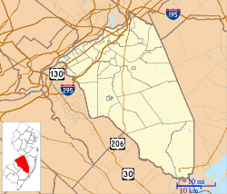 Browns Mills Junction  Browns Mills Junction  Browns Mills Junction Location of Browns Mills Junction in Burlington County (Inset: Location of county within the state of New Jersey) | |
| Coordinates: 39°56′54″N 74°35′24″W / 39.94833°N 74.59000°WCoordinates: 39°56′54″N 74°35′24″W / 39.94833°N 74.59000°W | |
| Country |
|
| State |
|
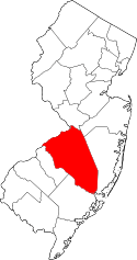
| County | Burlington |
| Township | Pemberton |
| Elevation[1] | 72 ft (22 m) |
| Time zone | Eastern (EST) (UTC-5) |
| • Summer (DST) | EDT (UTC-4) |
| GNIS feature ID | 874982[1] |

Browns Mills Junction is an unincorporated community located within Pemberton Township in Burlington County, New Jersey, United States.[2] The site, located about 1.6 miles (2.6 km) southwest of downtown Browns Mills, is located at the crossing of Junction Road (County Route 645) and the Philadelphia and Long Branch Railway, later a part of the Pennsylvania Railroad. It was the site of a train station named Browns Mills in-the-Pines where a short branch connected the main line to Browns Mills.[3] The settlement features a few houses along Junction Road and Mount Misery Road (also a part of CR 645 west of Junction Road) but is otherwise very forested as a part of the New Jersey Pine Barrens.[4]
References
- 1 2 "Browns Mills Junction". Geographic Names Information System. United States Geological Survey.
- ↑ Locality Search, State of New Jersey. Accessed March 14, 2015.
- ↑ Pennsylvania Railroad Company's Lines (Map). Philadelphia: Allen, Lane & Scott. July 1, 1899. Retrieved August 14, 2016.
- ↑ Google (August 14, 2016). "Aerial view of Browns Mills Junction" (Map). Google Maps. Google. Retrieved August 14, 2016.