Brotherton
| Brotherton | |
 Brotherton |
|
| Population | 728 |
|---|---|
| OS grid reference | SE481259 |
| – London | 160 mi (260 km) SSE |
| Civil parish | Brotherton |
| District | Selby |
| Shire county | North Yorkshire |
| Region | Yorkshire and the Humber |
| Country | England |
| Sovereign state | United Kingdom |
| Post town | KNOTTINGLEY |
| Postcode district | WF11 |
| Police | North Yorkshire |
| Fire | North Yorkshire |
| Ambulance | Yorkshire |
| EU Parliament | Yorkshire and the Humber |
Coordinates: 53°43′39″N 1°16′17″W / 53.72742°N 1.27151°W
Brotherton is a village and civil parish in the Selby district of North Yorkshire, England. The village is on a border with the City of Wakefield and West Yorkshire (here formed by the River Aire).
Brotherton was Historically part of the West Riding of Yorkshire. The village was on the A1 road 2 miles (3 km) north of Knottingley, before the road was relocated. It is now on the A162, north of Ferrybridge, south of Fairburn. Brotherton is often mistaken as being in West Yorkshire; it is a North Yorkshire village.
According to the 2001 census Brotherton civil parish had a population of 672, rising to 728 at the 2011 Census.[1]
Brotherton is the birthplace of Thomas of Brotherton, Earl of Norfolk, son of King Edward I and Margaret of France.[2] Notable Brotherton residents include Ken Wharton (b 1950), a writer of Military History books, who lived in the village between 2005 and 2009.
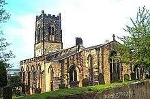
Brotherton Church of England parish church, dedicated to Edward the Confessor, is in the Diocese of Wakefield.
Governance
Brotherton is part of Fairburn with Brotherton electoral ward. The total population of this ward as measured at the 2011 Census was 3,538.[3]
References
- ↑ "Parish population 2011". Neighbourhood Statistics. Office for National Statistics. Retrieved 15 August 2015.
- ↑ Baines, Edward (1822). History, Directory & Gazeteer, of the County of York, Volume 1. Leeds: Edward Baines at the Leeds Mercury office. p. 274. Retrieved 14 September 2016.
- ↑ "Key Figures for 2011 Census: Key Statistics – Area: Fairburn with Brotherton (Ward)". Neighbourhood Statistics. Office for National Statistics. Retrieved 26 September 2016.
External links
 Media related to Brotherton at Wikimedia Commons