Beverly Hills, New South Wales
| Beverly Hills Sydney, New South Wales | |||||||||||||
|---|---|---|---|---|---|---|---|---|---|---|---|---|---|
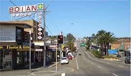 King Georges Road looking south | |||||||||||||
| Coordinates | 33°57′05″S 151°04′46″E / 33.9513°S 151.07938°ECoordinates: 33°57′05″S 151°04′46″E / 33.9513°S 151.07938°E | ||||||||||||
| Population | 9,661 (2011 census)[1] | ||||||||||||
| Postcode(s) | 2209 | ||||||||||||
| Location | 17 km (11 mi) south of Sydney CBD | ||||||||||||
| LGA(s) | |||||||||||||
| State electorate(s) | |||||||||||||
| Federal Division(s) | |||||||||||||
| |||||||||||||


Beverly Hills is a suburb in southern Sydney, in the state of New South Wales, Australia. Beverly Hills is located 17 kilometres south of the Sydney central business district and is part of the St George area. It is often colloquially referred to as "Bevo". The postcode is 2209, which it shares with neighbouring Narwee.
Beverly Hills is mostly residential, consisting of many freestanding red brick and tile bungalows built in the years immediately after World War 2. Many of these feature late Art Deco design elements. Medium density flats have been built in the areas close to King Georges Road and Stoney Creek Road.
History
Beverly Hills was originally known as Dumbleton after a local farm in the area, circa 1830. This name was generally disliked by residents who lobbied to supplant it with a more glamorous alternative to coincide with the arrival of the East Hills railway line, which opened 31 December 1931. The name was changed to Beverly Hills, at a time when Beverly Hills in California, USA was becoming famous for being the home of many famous movie stars. Real estate developments followed in the 1930s and 1940s. The post office opened 1 October 1940.[2]
Commercial area
The main shopping strip is located on King Georges Road, near the Beverly Hills railway station. The recent establishment in Commercial development called Dumbleton opened in late 2015 is set to bring back the Dumbleton feel for the area and more places are found scattered across along King Georges Road. There are over 40 different cafes, restaurants and takeaways along King Georges Road featuring Asian, Mediterranean, German and Modern Australian cuisines.
The area has all the features typical of Australian metropolitan localities: restaurants, retail shops, an IGA supermarket, real estate agents, a pub (the Beverly Hills Hotel), cinema, ATMs, kindergarten, primary/high schools, Scouts, parks, leisure and health facilities.
Transport
Beverly Hills railway station is on the Airport, Inner West & South Line of the Sydney Trains network.
The main road running through Beverly Hills is King Georges Road, connecting it north to Roselands and south to Hurstville. The road has palm trees running through its median strip as a nod to its Californian namesake. The other main road in Beverly Hills is Stoney Creek Road. This road intersects King Georges Road and connects Beverly Hills west to Peakhurst, Menai and east to Rockdale, Brighton-Le-Sands, Mascot and Sydney Airport.
Entrances to the M5 Motorway are located on King Georges Road, west of the shopping centre. The M5 Motorway connects east to Bexley North, Arncliffe, Sydney Airport and the Sydney CBD and west to Liverpool and Campbelltown.
Schools
Notable amongst the public buildings and amenities are Beverly Hills Girls' High School, Beverly Hills Primary School, Beverly Hills North Primary School and Regina Coeli Primary School. Beverly Hills Girls High School has approximately 1100 students and has been recently named a School of Excellence for its service to students of the Beverly Hills community.
Churches
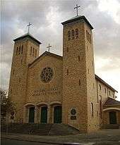
Regina Coeli Roman Catholic Church is Australia's only Catholic war memorial church. It was built in the early 1960s to commemorate the Australian-US alliance during World War 2. The flags of both nations are permanently hung on either side of the main altar, and a special Mass attended by US service personnel and diplomatic representatives is conducted there annually in commemoration of the Battle of the Coral Sea. Regina Coeli is sited prominently on the highest point in Beverly Hills, and is a landmark visible for many kilometres in all directions.
Other churches in the suburb include: St Matthews Anglican Church, St Bedes Anglican Church, Church@School, Beverly Hills Baptist Church, Beverly Hills Chinese Baptist Church, Beverly Hills Church of Christ, and Beverly Hills New Apostolic Church.
Parks and recreation
- Beverly Hills Park is located on Vanessa Street. It features two full-length football ovals and two barbecue areas.
- Vanessa Street Tennis Courts is located on Vanessa Street. It features two grass courts.
- Canterbury Golf Course is on Moorefields Road.
- Coolabah Street Tennis courts is located on Moorefields Road. It features four grass courts with a children's play and barbecue area.
Population
Demographics
According to the 2011 census of Population, there were 9,661 residents in Beverly Hills. 51.2% of people were born in Australia. The most common other countries of birth were China (excludes SARs and Taiwan) 12.5%, Hong Kong (SAR of China) 3.9% and Greece 2.5%. 39.7% of people only spoke English at home. Other languages spoken at home included Cantonese 14.9%, Mandarin 9.2%, Greek 8.6%, Arabic 5.0% and Italian 2.2%. The most common responses for religious affiliation were Catholic 26.2%, No Religion 17.6%, Eastern Orthodox 12.6%, Anglican 8.6% and Buddhism 7.2%.[1]
Notable residents
- Colin Dunmore Fuller (1882-1953) - farmer and soldier [3]
- Georgina McCready (1888-1980) - nurse, trade unionist and administrator [3]
References
- 1 2 Australian Bureau of Statistics (31 October 2012). "Beverly Hills (State Suburb)". 2011 Census QuickStats. Retrieved 29 April 2013.
- ↑ The Book of Sydney Suburbs, Frances Pollon, Angus & Robertson Publishers, 1990, Published in Australia ISBN 0-207-14495-8, page 27
- 1 2 Australian Dictionary of Biography
| Wikimedia Commons has media related to Beverly Hills, New South Wales. |