Carss Park, New South Wales
| Carss Park Sydney, New South Wales | |||||||||||||
|---|---|---|---|---|---|---|---|---|---|---|---|---|---|
 Carwar Avenue | |||||||||||||
| Population | 1,218 (2011 census)[1] | ||||||||||||
| Postcode(s) | 2221 | ||||||||||||
| Location | 17 km (11 mi) south of Sydney CBD | ||||||||||||
| LGA(s) | Georges River Council | ||||||||||||
| State electorate(s) | Kogarah | ||||||||||||
| Federal Division(s) | Cook | ||||||||||||
| |||||||||||||
Carss Park is a suburb in southern Sydney, in the state of New South Wales, Australia 17 kilometres south of the Sydney central business district in the local government area of the Georges River Council. Carss Park is part of the St George area.
Location
Carss Park is a picturesque suburb around Carss Point, overlooking Kogarah Bay on the Georges River. The suburb is surrounded by the suburbs of Kogarah Bay, Allawah, South Hurstville and Blakehurst. Carss Park is a mostly residential area featuring some valuable real estate with water views and bushland surrounds.
History
The area was purchased from the Crown on 28 January 1853 by Jonathon Croft for £123. It changed hands several times before being acquired in 1863 by William Carss, a cabinet-maker, who called his property Carss Bush. He built a stone cottage in the 1860s called Carss Park Cottage. After William Carss died, his family continued to live in the house, including daughter Mary Carss. William had left the estate to the trustees of the Sailor Home in Sydney. When Mary died this clause in her father’s will was honoured and the estate passed to the trustees in 1916.
In 1921 the Blakehurst Progress Association made attempts to secure Carss Bush for a public park and Kogarah council was able to acquire the land for the people. Carss Bush Park was dedicated on 26 January 1924 and 150 lots were auctioned on the same day for development. Many of the streets on the new estate were named after Aboriginal tribes.[2]
-

Carss Cottage side
-
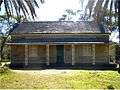
Carss Cottage front
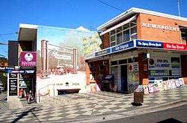
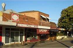
Commercial area
A small shopping strip is located on the Carwar Avenue near the intersection with the Princes Highway, containing a bottleshop, chemist, hairdresser, newsagent, petrol station and supermarket. A bus service operates between Hurstville and Kogarah via Carss Park.
Schools
Blakehurst Primary School is in the Carss Park area. While Mater Dei Catholic Primary School and Blakehurst High School are just outside.


Parks and recreation
Carss Park has several recreation facilities including an Olympic Swimming Pool, saltwater baths, a bicycle track and football fields. Parks in the suburb are Carss Bush Park, Carss Park, Todd Park, Parkside Drive Reserve and Fraser Park.
Population
Demographics
According to the 2011 Census of Population, there were 1,218 people usually resident in Carss Park. 26.4% stated they were born overseas with the top countries of birth being Greece 2.9%, China 2.6% and England 2.3%. English was stated as the only language spoken at home by 63.0% of residents and the most common other languages spoken were Greek 14.0%, Arabic 5.1% and Cantonese 2.6%. The most common responses for religious affiliation were Catholic 27.5%, Orthodox 21.2%, Anglican 17.6% and no religion 10.7%.[1]
Notable residents
- Bradley Clyde, rugby league player
- Kostya Tszyu, Australian/Russian boxer
Pop culture
- The Carss Park Motel was featured in the penultimate scene of The Square, a movie produced by Nash Edgerton and Joel Edgerton.
- The family home in popular television series Packed to the Rafters is supposed to be located in Carss Park, although the actual location is in Concord. Filming does, however, take place on location in Carss Park and surrounding suburbs.[3]
References
- 1 2 Australian Bureau of Statistics (31 October 2012). "Carss Park (State Suburb)". 2011 Census QuickStats. Retrieved 29 April 2013.
- ↑ The Book of Sydney Suburbs, Compiled by Frances Pollon, Angus & Robertson Publishers, 1990, Published in Australia ISBN 0-207-14495-8, page 53
- ↑ "Filming locations for 'Packed to the Rafters'". Retrieved 4 February 2010.
External links
- Alison Grellis (2008). "Carss Park". Dictionary of Sydney. Retrieved 26 September 2015. [CC-By-SA]
Coordinates: 33°59′14″S 151°07′08″E / 33.98718°S 151.11889°E