Revesby, New South Wales
| Revesby Sydney, New South Wales | |||||||||||||
|---|---|---|---|---|---|---|---|---|---|---|---|---|---|
 Marco Avenue, near The River Road | |||||||||||||
| Coordinates | 33°57′00″S 151°00′37″E / 33.95001°S 151.01016°ECoordinates: 33°57′00″S 151°00′37″E / 33.95001°S 151.01016°E | ||||||||||||
| Population | 12,935 (2011 census)[1] | ||||||||||||
| Postcode(s) | 2212 | ||||||||||||
| Location | 22 km (14 mi) south-west of Sydney CBD | ||||||||||||
| LGA(s) | Canterbury-Bankstown Council | ||||||||||||
| State electorate(s) | East Hills | ||||||||||||
| Federal Division(s) | Banks | ||||||||||||
| |||||||||||||
Revesby, a suburb of local government area Canterbury-Bankstown Council, is located 22 kilometres south-west of the Sydney central business district, in the state of New South Wales, Australia, and is a part of the South-western Sydney region.
Revesby is mostly a residential suburb, which was developed as part of Sydney's post-war urban sprawl, and contains many modest freestanding bungalows built from asbestos cement sheeting (fibro). Revesby is bounded on the north by Canterbury Road and the suburbs of Bankstown and Condell Park, on the south by Revesby Heights and Picnic Point, on the Georges River, on the west by Panania, and on the east by Padstow.
History
Revesby was named in 1913 in honour of Sir Joseph Banks, the famous botanist who sailed with Captain James Cook on the Endeavour, when he reached the east coast of Australia in 1770. Banks had inherited his father’s estate of Revesby Abbey, in Lincolnshire, England, so he was known as the Squire of Revesby. He is also commemorated in the Sir Joseph Banks High School in Turvey Street.
George Johnston, an officer of marines who had arrived on the First Fleet was granted land in this area in 1804. His wife Esther Julian, who had arrived as a convict on the same ship in 1788 was granted 570 acres (2.3 km2) in 1813. The earliest landowners did not reside in the area. The only mansion built in the early days was 'The Pah' on Tompson Road. It was built in 1896-97 by Samuel John Hales on 14 acres (57,000 m2) that had been purchased from the Weston estate. The property was subdivided in 1926 but the house remains.
The first school opened as Bankstown South in 1896; now known as Revesby Public School. The railway station opened on 21 December 1931. The local post office opened in 1955.[2]
Commercial area
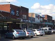
Revesby has a growing retail shopping centre, adjacent to Revesby railway station, centred on Marco Avenue and Selems Parade. It is also the site of several local government facilities including a senior citizens centre.
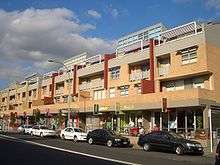
The Revesby shopping village is home to many banks, specialty retailers, restaurants and cafés. In the early 2000s, one of the largest Woolworths supermarkets in Sydney was built in Marco Avenue, across the road from the existing complex. On the original site, a combined residential and retail development called Revesby Abbey was completed in 2003. These developments brought a major increase in shoppers and business to the area. Revesby Abbey is now a popular spot for people to meet as it features many cafes, restaurants and boutiques lining the street.
Culture and entertainment
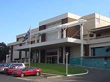
A major attraction of Revesby is the Revesby Workers' Club. Originally opened in 1962, today it has over 50,000 members, with extensive modern facilities. The most recent upgrades were completed in 2000, with further extensions currently under construction expected to significantly change the club, making it one of the largest in the state. The recent addition of a multi-level car park as well as another supermarket in close proximity has greatly increased access for locals for entertainment and products.
An Arts and Crafts Fair is held every month at Abel Reserve.
Transport
Revesby railway station is on the Airport, Inner West & South Line of the Sydney Trains network. During the morning and afternoon peak, express services run via Sydenham and Redfern.
Revesby is serviced by buses operated by Transdev NSW, generally following the routes established by McVicar's Bus Services.
Education
- Revesby Public School[3]
- Revesby South Public School
- Sir Joseph Banks High School
- St Lukes Catholic Primary School
- Broderick Gillawarna special needs school
- De La Salle College
A campus of the University of Western Sydney is in the neighbouring suburb of Milperra. Technical and Further Education (TAFE) courses are available at the nearby suburbs of Bankstown and Padstow.
Politics
For federal elections, Revesby is in the federal electoral division of Banks, held by Daryl Melham, of the Australian Labor Party. He has held it since the 1990 elections and was last re-elected in the 2007 elections. The seat has been held continuously by Labor since it was proclaimed in 1949 until the 2013 federal election where the Liberals David Coleman was elected.
For NSW state elections, Revesby is predominantly in the state electoral district of East Hills. This seat is currently held by Glenn Brookes.
Sport
- Panania-East Hills RSL Youth Soccer Club [4] is based at Kelso Reserve
- Revesby Workers Football Club [5] is based at Marco Reserve
- Revesby Rover's Football Soccer Club Inc.[6] is based at Amour Park
- St Christopher's Soccer Club [7] is based at Marco Reserve
- St Christophers Junior Rugby League Club, part of the Canterbury-Bankstown District Junior Rugby League. It has produced such players as Brent Sherwin, Graeme Hughes, Corey Hughes, Jarrad Hickey and Mark Riddell.
- Revesby Skate Park
References
- ↑ Australian Bureau of Statistics (31 October 2012). "Revesby (State Suburb)". 2011 Census QuickStats. Retrieved 19 April 2015.
- ↑ The Book of Sydney Suburbs, Compiled by Frances Pollon, Angus & Robertson Publishers, 1990, Published in Australia ISBN 0-207-14495-8, page 221
- ↑ http://www.revesby-p.schools.nsw.edu.au/
- ↑ http://www.pananiarslsoccer.com/
- ↑ http://www.revesbyworkersfc.com.au/
- ↑ http://www.revesbyrovers.com.au/
- ↑ http://www.saintsfc.org.au/
External links
| Wikimedia Commons has media related to Revesby, New South Wales. |