Washington State Route 99
| ||||
|---|---|---|---|---|
|
Pacific Highway William P. Stewart Memorial Highway | ||||
|
SR 99 is highlighted in red. | ||||
| Route information | ||||
| Defined by RCW 47.17.160 | ||||
| Maintained by WSDOT | ||||
| Length: | 49.13 mi[1] (79.07 km) | |||
| Existed: | 1964[2] – present | |||
| Southern segment | ||||
| South end: |
| |||
| Major junctions: |
| |||
| North end: |
| |||
| Northern segment | ||||
| South end: |
| |||
| Major junctions: |
| |||
| North end: |
| |||
| Location | ||||
| Counties: | Pierce, King, Snohomish | |||
| Highway system | ||||
| ||||

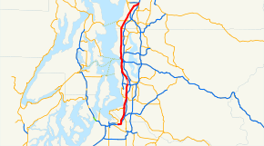
State Route 99 (SR 99), also known as the Pacific Highway and officially the William P. Stewart Memorial Highway, is a 49.13-mile-long (79.07 km) state highway serving the Seattle metropolitan area in the U.S. state of Washington. A 2-mile (3.2 km) gap divides the highway into two segments, between the interchanges of SR 518 and SR 599 in Tukwila. The southern segment of SR 99 travels north from Fife through the cities of Federal Way, Des Moines, Kent, and SeaTac to Tukwila. The northern segment of SR 99 continues north from Tukwila through Seattle, Shoreline, Edmonds, Lynnwood, to the Broadway Interchange in Everett.
Route description
Southern segment
SR 99 originates at Interstate 5 in Fife, near its own intersection with 54th Avenue E. From there, it heads eastward to Federal Way where it becomes Pacific Highway South and intersects SR 18 just west of its interchange with I-5. It then begins to travel north, through Des Moines, overlapping SR 509 for a few miles. The route becomes a little difficult to identify for several miles, as there are no reassurance signs until entering SeaTac. Once there, it becomes International Boulevard and forms the eastern boundary of the Seattle-Tacoma International Airport until crossing SR 518, where the southern division ends.
Northern segment

The northern division begins where the freeway carrying SR 599 northward passes over International Boulevard South. SR 599 terminates at that point; north of there, it becomes SR 99. SR 99 continues north to an interchange with SR 509 and West Marginal Way at the southern end of the First Avenue South Bridge. SR 99 crosses over the bridge and onto East Marginal Way, a surface street passing through the industrial and warehouse district of south Seattle known as SoDo. Near Spokane Street and the eastern end of the West Seattle Bridge, SR 99 again becomes a freeway. A portion travels on the surface before the route rises onto the Alaskan Way Viaduct, which traverses the downtown Seattle waterfront. The viaduct terminates at the Battery Street Tunnel, which runs for 3,140 feet (960 m) underneath Battery Street. The tunnel carries SR 99 underneath the Belltown neighborhood of Seattle and onto Aurora Avenue North.[3]
The tunnel was built in 1952 using the cut-and-cover method. It carries two traffic lanes in each direction, and connects the Alaskan Way Viaduct to Aurora Avenue N., providing continuity for State Route 99. There are no sidewalks or other provisions for pedestrians or bicyclists in the Tunnel. When an incident blocking traffic takes place within the tunnel, warning lights advise motorists to exit SR-99 at Western Avenue (northbound) and Denny Way (southbound). Emergency exits are placed behind sliding doors, with stairways leading up to Battery Street on the surface. The tunnel will be closed and filled in after the Alaskan Way Viaduct replacement tunnel opens.[4]
Aurora Avenue at this point is lined with businesses, residences, side streets and sidewalks. There is a median barrier, so cross traffic and left turns are not available; access is right-in/right-out (RIRO) only. There are also several pedestrian overpasses and underpasses along this route. As Aurora Avenue nears and passes along the east flank of Queen Anne Hill, the median barrier ends, although access remains RIRO. Aurora Avenue then crosses the Lake Washington Ship Canal on the George Washington Memorial Bridge (1932). At the interchange for Bridge Way, a very low median barrier begins, rising to a higher wall a bit north of North 38th Street. The barrier lowers again just beyond North 49th Street. Aurora Avenue then bisects Woodland Park, with the barrier replaced by paint stripes until the next side street, North 59th. The higher wall resumes as Aurora Avenue approaches the northbound entrance from Green Lake Way. Just north of North 68th Street, there is a traffic light-controlled crosswalk across Aurora Avenue through a narrow break in the median. RIRO access ends and cross traffic resumes just before Winona Avenue North, which is the first traffic light-controlled intersection on Aurora Avenue. Aurora Avenue continues northward to 145th Street, which intersection is also the west terminus of SR 523. At that point, SR 99 leaves Seattle and enters Shoreline as it continues northward on Aurora Avenue. SR 99 and Aurora Avenue crosses a former Interurban Railway right-of-way, now an urban trail, near North 155th Street.[5] It then continues north to the King County - Snohomish County line, which consists of a street marked North 205th Street in King County and 244th Street Southwest in Snohomish County.[3]
Upon entering Snohomish County and the city of Edmonds, the highway changes names to Pacific Highway North and crosses interchange with SR 104. The highway continues north into Edmonds.[3]

North of Edmonds, SR 99 enters Lynnwood, where it is known as Highway 99. SR 99 intersects SR 524 at 196th Street Southwest. SR 99 intersects SR 525 (known as the Mukilteo Speedway) at a partial interchange near Serene Lake. This interchange marks the northern end of the SR 525 freeway, which is an extension of Interstate 405.
After a journey through Lynnwood, SR 99 enters Everett, where it becomes known as Evergreen Way, until 3 miles (4.8 km) south of its terminus. At an intersection of Evergreen Way and Everett Mall Way, SR 99 goes northeast on Everett Mall Way. SR 99 passes the Mall near its interchange/intersection with Interstate 5, SR 526, and SR 527.
Before the completion of Interstate 5, SR 99 used to follow Evergreen Way onto Everett Mall Way (then known as "The Broadway Cut-Off") to Broadway; it then continued northbound through downtown Everett on Broadway. As Evergreen Way continues north in Everett, it becomes Rucker Avenue just south of 41st Street. Rucker Avenue intersects the former alignment of SR 526 at 41st Street.
History


Originally, State Route 99 was named Pacific Highway 1, which itself had been built over an earlier wagon road named R.F. Morrow Road.[6] SR 99 is a small part of the former US 99, which extended from the Canada–US border at the Peace Arch in Blaine, Wa. to Vancouver, Wa. at the Oregon Border. SR 99 is primarily the route of US 99 where building Interstate 5 along the same route would have been prohibitively expensive, or would not have served the greater good. Also, with the exception of the freeway sections, and from the Battery Street Tunnel to the north side of the George Washington Bridge (Aurora Bridge), SR 99 is tightly lined with stores, making any expansion nearly impossible. SR 99 used to be both US 99 and Primary State Highway (PSH) 1. As I-5 was built, these designations were moved to the new alignments from state line to international border until I-5 began being designated over the route. They were then co-signed briefly, and later, around the time of the 1964 state highway renumbering, SR 99 was redesignated over much of its former route. Slowly, over time, SR 99 was cut back to the current routing from Fife to Everett. In 2004 the state legislature removed the SR 99 designation from the part of the route along Tukwila International Boulevard in Tukwila. The same act also specified that the alignment south of SR 18 will be abandoned once the new SR 509 freeway is completed from Tacoma to Federal Way.[2]
Originally, US 99 was routed through the downtown Seattle streets, along 1st Avenue and 1st Avenue South. When the viaduct was built and US 99 was transferred to it, the old route became U.S. Route 99 Alternate (later Business). On the Alaskan Way Viaduct, near its southern terminus, there were ghost ramps on the east side of the structure. These were the only interchange structures created when the viaduct was first built in anticipation of the US 10 freeway (now Interstate 90) being completed into Seattle, and being extended to SR/US 99. However, the construction of the new downtown bypass tunnel has since removed this former portion of the original viaduct. To this day, an older US 99 sign is still in place on an overhead sign at the Columbia Street onramp to the Alaskan Way Viaduct in downtown Seattle.
Formerly, SR 99 extended through downtown Everett. However, shortly after the opening of the Boeing Freeway and the Everett Mall, SR 99 was rerouted via Everett Mall Way to terminate at the interchange of the Boeing Freeway (SR 526), SR 527, and I-5, but part of SR 99 still extends from the northern part of Everett as State Route 529, becoming State Street through Marysville, then Smokey Point Boulevard.
Many cities and towns along the I-5 corridor in Washington have streets named 'Highway 99', 'Old Highway 99', 'Pacific Highway', or simply 'Old 99' all used to be part of US 99. Those cities with the streets still designated 'Highway 99' can cause confusion with people unfamiliar with the area, as they expect the street to be part of SR 99. This is most apparent in Vancouver, Washington whose "Hwy 99" is often confused for a state route.
When known as 'US 99', the highway received federal funding for maintenance; at the point when federal funding was no longer provided, the road designation was changed to 'SR 99'.
On November 27, 1998, a gunman shot and killed bus driver Mark McLaughlin on Seattle's 359 bus route, which runs down Highway 99. The gunman, Silas Cool, then shot and killed himself. At the time of the incident, the bus was traveling southbound across the George Washington Memorial Bridge over the Lake Washington Ship Canal, on Aurora Avenue North. After McLaughlin was shot, the bus veered across two lanes of traffic and plunged 50 feet off the bridge into Seattle's Fremont neighborhood. It landed on an apartment building and then tumbled to the ground. The driver, gunman, and one other passenger died, and 32 other passengers were injured. [7] After the incident, the route was renamed 358. [8]
In recent years, three segments of State Route 99 have had their curb lanes converted to business access and transit lanes (BAT lanes) to accommodate increased bus service that was later converted to bus rapid transit. Swift Bus Rapid Transit between Shoreline and Everett began service in 2009,[9] the RapidRide A Line from Federal Way to Tukwila began operating in 2010, and the RapidRide E Line from Downtown Seattle to Shoreline replaced King County Metro route 358 in 2014.[10]
Names and designations
In 1939, the Washington state legislature named the road "Jefferson Davis Highway", making it the final component of the Jefferson Davis Memorial Highway, which the United Daughters of the Confederacy intended to travel through the South and up the west coast to Canada.[11] In 2002, the state's House of Representatives unanimously approved a bill that would have removed Davis' name from the road. However, a committee of the state's Senate subsequently killed the proposal.[12][13]
In May 2016, the highway was designated as the William P. Stewart Memorial Highway, named after an African-American Civil War veteran and early settler in Snohomish.[14]
Major intersections
| County | Location | mi[1] | km | Destinations | Notes | ||
|---|---|---|---|---|---|---|---|
| Pierce | Fife | 0.00 | 0.00 | Southern terminus | |||
| 54th Street East | Continuation beyond I-5 | ||||||
| Milton | 1.62 | 2.61 | Porter Way | Former SR 514 | |||
| King | Federal Way | 4.49 | 7.23 | ||||
| 7.72 | 12.42 | South end of SR 509 overlap | |||||
| Des Moines | 11.84 | 19.05 | North end of SR 509 overlap | ||||
| SeaTac | 15.11 | 24.32 | South 182nd Street – Sea–Tac Airport | ||||
| SeaTac–Tukwila city line | 16.78 | 27.00 | Interchange; south end of gap | ||||
| Tukwila International Boulevard | Continuation beyond SR 518 | ||||||
| Gap in route | |||||||
| Tukwila | 16.79 | 27.02 | Interchange; north end of gap | ||||
| Tukwila International Boulevard | Continuation beyond SR 599 | ||||||
| South end of freeway | |||||||
| 17.61 | 28.34 | West Marginal Place South | Northbound exit and entrance | ||||
| Seattle | 18.63 | 29.98 | Des Moines Drive, 14th Avenue South | ||||
| 19.22 | 30.93 | South Cloverdale Street | Northbound entrance only | ||||
| 19.56 | 31.48 | South Kenyon Street – South Park | Southbound exit and entrance | ||||
| North end of freeway | |||||||
| 20.27 | 32.62 | ||||||
| Duwamish River | 20.27– 20.82 | 32.62– 33.51 | First Avenue South Bridge | ||||
| Seattle | 20.60 | 33.15 | |||||
| South end of freeway | |||||||
| 22.65 | 36.45 | Spokane Street – West Seattle | Northbound exit and southbound entrance | ||||
| 22.74 | 36.60 | West Seattle Bridge – Harbor Island | Southbound exit and northbound entrance | ||||
| 24.24 | 39.01 | South Atlantic Street | Southbound exit and northbound entrance | ||||
| 25.03 | 40.28 | Columbia Street | Southbound entrance only | ||||
| 25.04 | 40.30 | Seneca Street | Northbound exit only | ||||
| 25.69 | 41.34 | Western Avenue | |||||
| 25.78– 26.18 | 41.49– 42.13 | Battery Street Tunnel | |||||
| 26.30 | 42.33 | Denny Way – Downtown Seattle | Southbound exit and northbound entrance | ||||
| North end of freeway | |||||||
| 26.52 | 42.68 | Interchange; northbound exit only | |||||
| 26.56 | 42.74 | Broad Street | Interchange; southbound exit only | ||||
| Lake Union | 27.91– 28.47 | 44.92– 45.82 | George Washington Memorial Bridge | ||||
| Seattle | 28.57 | 45.98 | North 38th Street | Interchange | |||
| 29.21 | 47.01 | North 46th Street | Interchange | ||||
| 30.04 | 48.34 | North 63rd Street, Green Lake Way | Interchange | ||||
| Seattle–Shoreline city line | 34.21 | 55.06 | |||||
| King–Snohomish county line | Shoreline–Edmonds city line | 37.23 | 59.92 | ||||
| 37.34 | 60.09 | Interchange | |||||
| Snohomish | Lynnwood | 40.58 | 65.31 | ||||
| | 44.36 | 71.39 | Interchange | ||||
| Everett | 48.96– 49.13 | 78.79– 79.07 | |||||
| 49.13 | 79.07 | Northern terminus | |||||
| Broadway | Continuation beyond SR 526/SR 527 | ||||||
1.000 mi = 1.609 km; 1.000 km = 0.621 mi
| |||||||
References
- 1 2 Finch, Mark, ed. (March 4, 2014). State Highway Log: Planning Report 2013, SR 2 to SR 971 (PDF) (Report). Washington State Department of Transportation. pp. 861–891. Retrieved April 17, 2014.
- 1 2 "47.17.160: State route No. 99". Revised Code of Washington. Washington State Legislature. 1970; revised 1971, 1979, 2004. Retrieved April 17, 2014. Check date values in:
|date=(help) - 1 2 3 Seattle, Washington, city series (maps), American Automobile Association, 2008
- ↑ "Alaskan Way Viaduct - FAQs". Washington State Department of Transportation. WSDOT. Retrieved August 11, 2013.
- ↑ City of Shoreline, Interurban Trail. Retrieved on April 18, 2010.
- ↑ "SR 99 North: North End of Battery Street Tunnel to N. 145th Street Route Development Plan" (PDF). Washington State Department of Transportation. Retrieved December 3, 2007.
- ↑ McRoberts, Patrick (December 3, 1998). "Metro bus plunges off Seattle's Aurora Bridge after driver is shot on November 27, 1998.". HistoryLink. Retrieved September 24, 2015.
- ↑ Argo, Jason (May 12, 2010). "In defense of the 358". Seattle Post-Intelligencer. Retrieved September 24, 2015.
- ↑ Lindblom, Mike (November 30, 2009). "Bus rapid transit launches today from Everett to Shoreline". The Seattle Times. Retrieved September 24, 2015.
- ↑ Lindblom, Mike (February 15, 2014). "Aurora Avenue North bus now RapidRide". The Seattle Times. Retrieved September 24, 2015.
- ↑ Ray, Susanna (January 24, 2002). "Jefferson Davis Highway here? Legislator outraged". The Everett Herald. Retrieved November 8, 2013.
- ↑ Verhovek, Sam Howe (February 14, 2002). "Road Named for Jefferson Davis Stirs Spirited Debate". The New York Times. Retrieved October 13, 2013.
- ↑ "Senate Committee Kills Plan To Rename Jefferson Davis Highway". KOMO News. Seattle, Washington: Sinclair Interactive Media. August 30, 2006. Retrieved July 21, 2016.
- ↑ Cornfield, Jerry (May 18, 2016). "SR 99 to be renamed for Snohomish black Civil War soldier". The Everett Herald. Retrieved May 18, 2016.