Interstate 405 (Washington)
| ||||
|---|---|---|---|---|
| Renton Freeway | ||||
 | ||||
| Route information | ||||
| Auxiliary route of I‑5 | ||||
| Defined by RCW 47.17.595 | ||||
| Maintained by WSDOT | ||||
| Length: | 30.30 mi[1] (48.76 km) | |||
| Existed: | 1964 – present | |||
| Major junctions | ||||
| South end: |
| |||
|
| ||||
| North end: |
| |||
| Location | ||||
| Counties: | King, Snohomish | |||
| Highway system | ||||
| ||||
.svg.png)
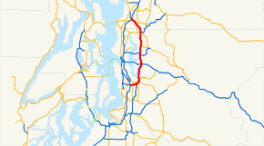
Interstate 405 (abbreviated I-405, and colloquially referred to as 405 or four-oh-five) in Washington is a 30-mile (48 km) stretch of freeway that bypasses Seattle east of Lake Washington. The northern terminus is in Lynnwood and the southern terminus is in Tukwila. The highway runs through what has since become the "Eastside" technology center of Bellevue and Kirkland, making it an often congested commuter path. I-405 is known for its meandering "S-curves" through Renton. It intersects with Interstate 90 and a number of major state routes. Interstate 405 was laid over Secondary State Highway 2A.
Route description
I-405 begins as a continuation of Washington State Route 518 (SR 518) at the junction with Interstate 5 in Tukwila and almost immediately after the change to I-405, a High-occupancy vehicle lane begins, and continues to almost the end of the highway. The freeway continues on an easterly path, passing the newly renovated Westfield Southcenter shopping mall and crossing the Green River before approaching an interchange with SR 181. After the exit, the former Longacres race track, now owned by Boeing,[2] and new Sounder commuter rail station for Tukwila is passed, and I-405 starts to head north-east towards a cloverleaf interchange with SR 167 and Rainier Avenue, which is the first exit in Renton. After the interchange with SR 167, the freeway, after a series of infamous s-curves, which become a traffic bottleneck during rush hour,[3] turns to a northerly direction and intersects SR 169 and one direction of SR 900. A hybrid diamond interchange/partial cloverleaf interchange serves the other direction of SR 900 and the Gene Coulon Memorial Beach Park and a new development called The Landing.
Climbing Kennydale Hill,[3] I-405 intersects N 30th St and Kennewick Place NW, which serves north Renton, and Kennydale, before quickly descending to another hybrid diamond/partial cloverleaf interchange with NE 44th Street, which provides access to Newcastle. I-405 now closely follows Lake Washington, and enters a wooded section until an interchange with Lake Washington Boulevard and 112th Ave SE which serves both a park and ride station and the community of Newport Hills. The final interchange before I-90 is a diamond interchange serving Coal Creek Parkway.

Factoria Mall is east of I-405 as it approaches a full stack interchange with Interstate 90 which provides access to Seattle, Mercer Island, as well as the Eastgate neighborhood of Bellevue and Issaquah. Mercer Slough is west of I-405 as it heads towards downtown Bellevue. A 2008 construction project demolished the Wilburton Tunnel which formerly covered a portion of the freeway between Factoria and Bellevue.[4]
The historic Wilburton Trestle passes I-405 as a diamond interchange with SE 8th Street connects the freeway to South Bellevue and the Lake Hills area. In quick succession is a short diamond interchange with NE 4th Street, a full cloverleaf with NE 8th Street, serving downtown Bellevue and Overlake Medical Center, and an HOV only left exit to the Bellevue Transit Center and NE 6th Street. SR 520 which provides access to Medina and Redmond, home of the Microsoft Corporation is the next interchange, with a half cloverleaf interchange with several fly-over ramps to allow complete access to and from SR 520.
Bridle Trails State Park borders the freeway on the east side, while Watershed Park and Northwest University are on the western side of the freeway as it approaches NE 70th Place, serving Houghton and Snyders Corner before approaching a full cloverleaf with former SR 908 serving Kirkland. An incomplete interchange with NE 116th Street comes before I-405 connects to Totem Lake via an interchange with NE 124th Street and an HOV only left exit to the Evergreen Hospital and NE 128th Street. NE 160th Street is the next interchange before I-405 crosses over the Sammamish River and connects to SR 522 which provides access to downtown Bothell and Woodinville. An interchange with NE 195th Street provides access to the local business park and the University of Washington Bothell branch.
Entering Snohomish County at mile post 25, I-405 enters a wooded area before coming to an interchange with the Bothell-Everett Highway (SR 527), which is the final interchange before I-405 terminates at an interchange between Interstate 5 and SR 525.[5]
As of 2007, the most heavily traveled section of I-405 is near SE 8th Street in downtown Bellevue, with a daily average of 200,000 cars per day traveling through this segment.[6] This number was slightly lower in 1997, with 190,000 cars per day,[7] but has dramatically increased since the first measurement in 1967, with 32,600 cars per day traveling through Bellevue.[8]
History
The first road connecting most of the eastside communities, Secondary State Highway 2A (SSH 2A),[9] was already in existence since at least 1927. SSH 2A connected US 10 and US 410 in Renton to the north, through Kirkland and Bothell, connecting back to US 99 in Everett.[10] In 1964, the system of Primary and Secondary state highways was removed in favor of signed routes, and PSH 2A was renumbered SR 405. The first segment of the interstate to be completed was between Tukwila and Renton, opening to traffic on August 31, 1965.[11] By 1971, SR 405 was renumbered to Interstate 405 after it was completely improved to Interstate Highway standards.
One of the major construction projects on the highway was straightening the s-curves in Renton. This project began in 1990, and was estimated to cost $70 million. Also during this time the portion of the highway between I-5 and South Renton was being repaved and HOV lanes were being added.[12]
On September 27, 2015, a set of high-occupancy toll lanes (HOT lanes) opened on I-405 between Bellevue and Lynnwood, replacing the existing HOV lanes from NE 6th Street to I-5/SR 525.[13][14]
Future
Originally intended as a bypass to I-5 through Seattle, I-405 has experienced a large increase in traffic volume since its construction. I-405 is now the most congested freeway in Washington State, particularly the segment between State Route 169 and I-90.[15]
Currently underway is the Nickel Project, which in 2003 originally included three planned improvements for I-405:[16]
- The construction of one lane in each direction between SE 8th and I-90, replacing the Wilburton Tunnel.
- The construction of one northbound lane from NE 70th to NE 124th, and one southbound lane from SR 522 to SR 520.
- The construction of one northbound lane from SR 181 to SR 167, and one southbound lane from SR 169 to SR 167.
In 2005, the "Renton to Bellevue Project" was added as part of the Nickel Project,[17] and would have added two lanes in each direction between SR 169 and I-90. However, in November 2007, voters rejected the ballot measure which would have provided the additional funds necessary for this project. At this time the project is still largely unfunded.[15] The web site "Road to Ruin" ranks the widening of I-405 as the fourth most wasteful highway project in the United States. The project is designed to help traffic move smoother on I-405.[18]
A bus rapid transit line is proposed for nearly the entire length of I-405 as part of the Sound Transit 3 ballot measure.
Exit list
| County | Location | mi[1] | km | Exit[19] | Destinations | Notes |
|---|---|---|---|---|---|---|
| King | Tukwila | 0.00 | 0.00 | Continuation beyond I-5, north exit 154, south exit 154B; southern terminus | ||
| 0.00 | 0.00 | Southbound exit and northbound entrance; I-5 north exit 154, south exit 154A | ||||
| 0.34 | 0.55 | Southcenter Boulevard – Southcenter Mall | Southbound exit and northbound entrance | |||
| 0.96 | 1.54 | 1 | ||||
| Renton | 2.30 | 3.70 | 2 | Signed as exits 2A (south) and 2B (north) southbound | ||
| 2.96 | 4.76 | 3 | Southbound exit and northbound entrance | |||
| 3.99– 4.47 | 6.42– 7.19 | 4 | South end of SR 900 overlap | |||
| 5.37 | 8.64 | 5 | North end of SR 900 overlap | |||
| 6.48 | 10.43 | 6 | Northeast 30th Street | |||
| 7.44 | 11.97 | 7 | Northeast 44th Street | |||
| Bellevue | 9.23 | 14.85 | 9 | 112th Avenue Southeast – Newcastle | ||
| 10.15 | 16.33 | 10 | Coal Creek Parkway – Factoria | |||
| 11.02 | 17.73 | 11 | I-90 west exit 10, east exit 10A | |||
| 12.76 | 20.54 | 12 | Southeast 8th Street, 116th Avenue Northeast | |||
| 13.54 | 21.79 | 13A | Northeast 4th Street | |||
| 13.68 | 22.02 | Northeast 6th Street | HOV access only[20] | |||
| 13.81 | 22.23 | 13B | Northeast 8th Street | |||
| 14.82 | 23.85 | 14 | ||||
| Kirkland | 17.43 | 28.05 | 17 | Northeast 70th Place | ||
| 18.08 | 29.10 | 18 | Northeast 85th Street – Redmond, Kirkland | |||
| 19.82 | 31.90 | 20A | Northeast 116th Street | Northbound exit and southbound entrance | ||
| 20.30 | 32.67 | 20B | Northeast 124th Street | Signed as exit 20 southbound | ||
| 20.64 | 33.22 | Northeast 128th Street | HOV access only[21] | |||
| | 22.61 | 36.39 | 22 | Northeast 160th Street | ||
| Bothell | 23.52 | 37.85 | 23 | Signed as exits 23A (east) and 23B (west) southbound | ||
| 24.46 | 39.36 | 24 | Northeast 195th Street, Beardslee Boulevard | |||
| Snohomish | 26.73 | 43.02 | 26 | |||
| | 30.30 | 48.76 | Northbound exit and southbound entrance; I-5 south exit 182 | |||
| | 30.30 | 48.76 | Continuation beyond I-5, north exit 182; northern terminus | |||
1.000 mi = 1.609 km; 1.000 km = 0.621 mi
| ||||||
References
- 1 2 "State Highway Log - Planning Report - SR 2 to SR 971" (PDF). Washington State Department of Transportation. 2006. Retrieved August 16, 2008.
- ↑ Lane, Polly; Smith, Sara (September 27, 1990). "Boeing Buys Longacres-- Site May Be Company Headquarters; Some Racing Possible Elsewhere". The Seattle Times. Retrieved September 27, 2008.
- 1 2 Gilmore, Susan (June 30, 2002). "Straight talk on S-curves, traffic lingo". Bumper to Bumper. The Seattle Times. Retrieved September 28, 2008.
- ↑ "I-405 lane closures, other traffic headaches loom this weekend". Seattle Times. August 15, 2008. Retrieved August 16, 2008.
- ↑ Google (August 16, 2008). "Interstate 405 (Overview)" (Map). Google Maps. Google. Retrieved August 16, 2008.
- ↑ "2007 Annual Traffic Report" (PDF). Washington Department of Transportation. Retrieved August 16, 2008.
- ↑ "1997 Annual Traffic Report" (PDF). Washington Department of Transportation. Retrieved September 27, 2008.
- ↑ "1970 Annual Traffic Report" (PDF). Washington Department of Transportation. Retrieved September 27, 2008.
- ↑ "40 Years With the Washington State Department of Highways" (PDF). Washington State Department of Transportation. Retrieved September 28, 2008.
- ↑ Official Auto Tails map, Washington, Oregon (Map). Rand McNally. 1927. Seattle and Vicinity inset. Retrieved September 27, 2008.
- ↑ "3 Miles of Renton Freeway Opened". The Seattle Times. August 31, 1965. p. 6.
- ↑ Aweeka, Charles (September 25, 1990). "S-Curves On I-405 To Be Set Straight -- First, Water Pipes Will Be Rerouted". The Seattle Times. Retrieved September 28, 2008.
- ↑ "I-405 express toll lanes will open on Sept. 27" (Press release). Washington State Department of Transportation. August 20, 2015. Retrieved September 27, 2015.
- ↑ Lindblom, Mike (September 19, 2015). "Q&A: a guide to using I-405's new express toll lanes". The Seattle Times. Retrieved September 27, 2015.
- 1 2 "I-405 - Renton To Bellevue Project SR 169 to I-90". Washington State Department of Transportation. Retrieved April 7, 2007.
- ↑ "Nickel Funding Package Enacted for Transportation by the Washington State Legislature" (PDF). Washington State Department of Transportation. Retrieved December 6, 2007.
- ↑ "I-405 New 2005 Funded Projects". Washington State Department of Transportation. Archived from the original on June 7, 2008. Retrieved December 6, 2007.
- ↑ Taxpayers for Common Sense. "Road to Ruin" (PDF). Retrieved December 6, 2007.
- ↑ Interstate 405 north of Bothell to south of Renton (Map). Washington State Department of Transportation. Retrieved August 16, 2008.
- ↑ "I-405 - Access Downtown Project - Complete December 2004". Washington State Department of Transportation. December 2004. Archived from the original on September 6, 2008. Retrieved September 27, 2008.
- ↑ Washington State Department of Transportation. "I-405 - Totem Lake Freeway Station". Retrieved March 2008. Check date values in:
|access-date=(help)
External links
| Wikimedia Commons has media related to Interstate 405 (Washington). |
| ||