Barr's Subdivision Historic District
|
Barr's Subdivision Historic District | |
|
House at the corner of Howard Avenue and State Street | |
  | |
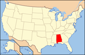
| Location | Roughly along US 45 and Howard Ave. between LeBaron and State, Citronelle, Alabama |
|---|---|
| Coordinates | 31°5′30″N 88°14′21″W / 31.09167°N 88.23917°WCoordinates: 31°5′30″N 88°14′21″W / 31.09167°N 88.23917°W |
| Area | 5.9 acres (2.4 ha) |
| Architectural style | Late 19th And Early 20th Century American Movements, Late Victorian |
| NRHP Reference # | 89002452[1] |
| Added to NRHP | January 25, 1990 |
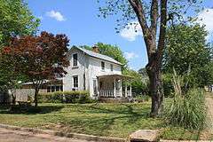
Barr's Subdivision Historic District is a historic district in Citronelle, Alabama, United States. It is roughly bounded by U.S. Route 45 and Howard Avenue between LeBaron Avenue and State Street. The district covers 5.9 acres (0.024 km2) and contains 7 contributing properties.[2] It was placed on the National Register of Historic Places on July 7, 2005.[1]
References
- 1 2 National Park Service (2009-03-13). "National Register Information System". National Register of Historic Places. National Park Service.
- ↑ Bemis, Devereaux; Steven M. Kay (May 23, 1989). "Barr's Subdivision Historic District" (PDF). National Register of Historic Places Registration Form. National Park Service. Archived (PDF) from the original on March 16, 2014. Retrieved March 16, 2014. See also: "Accompanying photos" (PDF). Archived (PDF) from the original on March 16, 2014. Retrieved March 16, 2014.

This article is issued from Wikipedia - version of the 11/27/2016. The text is available under the Creative Commons Attribution/Share Alike but additional terms may apply for the media files.