Central Core Historic District
|
Central Core Historic District | |
|
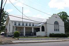
Citronelle Memorial Library in 2010, part of the Central Core Historic District | |
  | |
| Location | Roughly State and LeBaron from Mobile to Second, Citronelle, Alabama |
|---|---|
| Coordinates | 31°5′28″N 88°13′19″W / 31.09111°N 88.22194°WCoordinates: 31°5′28″N 88°13′19″W / 31.09111°N 88.22194°W |
| Area | 69.9 acres (28.3 ha) |
| Architectural style | Late Victorian, Vernacular Victorian |
| NRHP Reference # | 89002424[1] |
| Added to NRHP | January 25, 1990 |
The Central Core Historic District is a historic district in Citronelle, Alabama, United States. It is roughly bounded by State Street and LeBaron Avenue from Mobile to Second streets. The district covers 69.9 acres (0.283 km2) and contains 62 contributing properties.[2] It was placed on the National Register of Historic Places on January 25, 1990.[1]
References
- 1 2 National Park Service (2009-03-13). "National Register Information System". National Register of Historic Places. National Park Service.
- ↑ Bemis, Devereaux; Steven M. Kay (May 23, 1989). "Central Core Historic District". National Register of Historic Places Registration Form. National Park Service. See also: "Accompanying photos" (PDF). Archived (PDF) from the original on April 23, 2014. Retrieved April 23, 2014.
| Topics | |
|---|---|
| Lists by states |
|
| Lists by insular areas | |
| Lists by associated states | |
| Other areas | |
| |
This article is issued from Wikipedia - version of the 11/27/2016. The text is available under the Creative Commons Attribution/Share Alike but additional terms may apply for the media files.