National Register of Historic Places listings in Russell County, Alabama
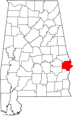
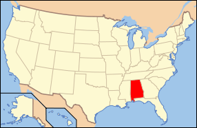
Location of Russell County in Alabama
This is a list of the National Register of Historic Places listings in Russell County, Alabama.
This is intended to be a complete list of the properties and districts on the National Register of Historic Places in Russell County, Alabama, United States. Latitude and longitude coordinates are provided for many National Register properties and districts; these locations may be seen together in a Google map.[1]
There are 24 properties and districts listed on the National Register in the county, including 3 National Historic Landmarks.
- This National Park Service list is complete through NPS recent listings posted December 16, 2016.[2]
Current listings
| [3] | Name on the Register | Image | Date listed[4] | Location | City or town | Description |
|---|---|---|---|---|---|---|
| 1 | Apalachicola Fort | 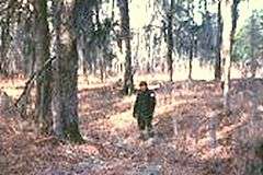 |
(#66000931) |
Address Restricted |
Holy Trinity | |
| 2 | Bass-Perry House | 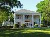 |
(#76000355) |
4 miles northeast of Seale on U.S. Route 431 32°20′46″N 85°07′57″W / 32.346111°N 85.1325°W |
Seale | |
| 3 | Brooks-Hughes House | 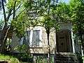 |
(#83003477) |
1010 Sandfort Rd. 32°27′33″N 85°00′29″W / 32.459167°N 85.008056°W |
Phenix City | |
| 4 | Brownville-Summerville Historic District | Upload image | (#83003479) |
Roughly bounded by 15th and 23rd Sts. and 6th and 11th Aves. 32°28′40″N 85°00′17″W / 32.477778°N 85.004722°W |
Phenix City | |
| 5 | Floyd-Newsome House | 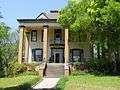 |
(#83004373) |
900 22nd St. 32°28′56″N 85°00′15″W / 32.482222°N 85.004167°W |
Phenix City | |
| 6 | Fort Mitchell Site | 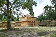 |
(#72000178) |
Address Restricted |
Fort Mitchell | |
| 7 | Fort No. 5 | 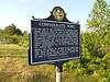 |
(#76000354) |
West of Phenix on the Opelika Highway 32°29′00″N 85°02′04″W / 32.483333°N 85.034444°W |
Phenix City | |
| 8 | Girard High School | Upload image | (#83003480) |
Sandfort Rd. 32°27′38″N 85°00′14″W / 32.460556°N 85.003889°W |
Phenix City | The old Girard High School on Sandfort Road was demolished in 1994 |
| 9 | Girard Historic District | Upload image | (#83003481) |
Roughly bounded by 8th Pl., 10th St., 5th and 8th Aves. 32°27′45″N 85°00′06″W / 32.4625°N 85.001667°W |
Phenix City | |
| 10 | Glenn-Thompson Plantation | 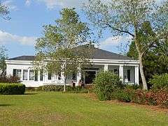 |
(#80000735) |
South of Pittsview on U.S. Route 431 32°08′12″N 85°09′06″W / 32.136667°N 85.151667°W |
Pittsview | |
| 11 | Glennville Historic District | 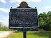 |
(#79000402) |
South of Pittsview 32°06′38″N 85°10′09″W / 32.110556°N 85.169167°W |
Pittsview | |
| 12 | Joel Hurt House | 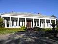 |
(#05000834) |
605 Church St. 32°14′25″N 85°24′38″W / 32.240278°N 85.410556°W |
Hurtsboro | |
| 13 | Hurtsboro Historic District |  |
(#09000001) |
308-905 Church St., 508 Daniel St., 303-407 Dickinson St., 302-802 Goolsby St., 402-502 Lloyd St., and 242-282 Long St. 32°14′40″N 85°24′47″W / 32.244475°N 85.413117°W |
Hurtsboro | |
| 14 | Kid Alley Residential Historic District | Upload image | (#83003482) |
11th Ave. at 9th Pl. 32°27′52″N 85°00′27″W / 32.464444°N 85.0075°W |
Phenix City | |
| 15 | Lower Twentieth Street Residential Historic District | Upload image | (#83003483) |
20th St. from 2nd to 6th Aves. 32°28′47″N 84°59′55″W / 32.479722°N 84.998611°W |
Phenix City | |
| 16 | Morgan-Curtis House |  |
(#83003484) |
1815 Abbott Dr. 32°28′05″N 85°01′08″W / 32.468056°N 85.018889°W |
Phenix City | |
| 17 | Samuel R. Pitts Plantation |  |
(#92000819) |
East of U.S. Route 431, south of the Southern railroad tracks 32°10′43″N 85°09′28″W / 32.178611°N 85.157778°W |
Pittsview | |
| 18 | Russell County Courthouse at Seale | 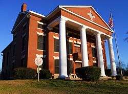 |
(#74000436) |
Courthouse Sq. 32°17′54″N 85°10′03″W / 32.298333°N 85.1675°W |
Seale | |
| 19 | Shapre-Monte House |  |
(#83003485) |
721 6th Ave. 32°27′32″N 85°00′07″W / 32.458889°N 85.001944°W |
Phenix City | |
| 20 | Smith Residential Historic District | Upload image | (#83003486) |
20th St., 7th Ave., and 6th Court 32°28′47″N 85°00′04″W / 32.479722°N 85.001111°W |
Phenix City | |
| 21 | Snow Valley Residential Historic District | Upload image | (#83003487) |
11th and 12th Sts. at 11th Ave. 32°28′04″N 85°00′29″W / 32.467778°N 85.008056°W |
Phenix City | |
| 22 | Uchee Methodist Church | 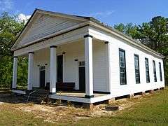 |
(#97000654) |
County Road 22, 1.8 miles west of its junction with County Road 65 32°21′11″N 85°19′53″W / 32.353056°N 85.331389°W |
Uchee | |
| 23 | Upper Twentieth Street Residential Historic District | Upload image | (#83003488) |
1201-1217 W. 20th St. 32°28′45″N 85°00′38″W / 32.479167°N 85.010556°W |
Phenix City | |
| 24 | Yuchi Town |  |
(#95000453) |
Address Restricted |
Fort Benning |
See also
| Wikimedia Commons has media related to National Register of Historic Places in Russell County, Alabama. |
- List of National Historic Landmarks in Alabama
- National Register of Historic Places listings in Alabama
References
- ↑ The latitude and longitude information provided in this table was derived originally from the National Register Information System, which has been found to be fairly accurate for about 99% of listings. For about 1% of NRIS original coordinates, experience has shown that one or both coordinates are typos or otherwise extremely far off; some corrections may have been made. A more subtle problem causes many locations to be off by up to 150 yards, depending on location in the country: most NRIS coordinates were derived from tracing out latitude and longitudes off of USGS topographical quadrant maps created under the North American Datum of 1927, which differs from the current, highly accurate WGS84 GPS system used by most on-line maps. Chicago is about right, but NRIS longitudes in Washington are higher by about 4.5 seconds, and are lower by about 2.0 seconds in Maine. Latitudes differ by about 1.0 second in Florida. Some locations in this table may have been corrected to current GPS standards.
- ↑ "National Register of Historic Places: Weekly List Actions". National Park Service, United States Department of the Interior. Retrieved on December 16, 2016.
- ↑ Numbers represent an ordering by significant words. Various colorings, defined here, differentiate National Historic Landmarks and historic districts from other NRHP buildings, structures, sites or objects.
- ↑ The eight-digit number below each date is the number assigned to each location in the National Register Information System database, which can be viewed by clicking the number.

Municipalities and communities of Russell County, Alabama, United States | ||
|---|---|---|
| City | | |
| Town | ||
| CDP | ||
| Unincorporated communities | ||
| Former city | ||
| Footnotes | ‡This populated place also has portions in an adjacent county or counties | |
This article is issued from Wikipedia - version of the 5/21/2016. The text is available under the Creative Commons Attribution/Share Alike but additional terms may apply for the media files.