National Register of Historic Places listings in Marshall County, Alabama
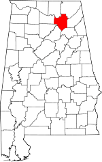
Location of Marshall County in Alabama
This is a list of the National Register of Historic Places listings in Marshall County, Alabama.
This is intended to be a complete list of the properties and districts on the National Register of Historic Places in Marshall County, Alabama, United States. Latitude and longitude coordinates are provided for many National Register properties and districts; these locations may be seen together in an online map.[1]
There are 15 properties and districts listed on the National Register in the county.
- This National Park Service list is complete through NPS recent listings posted December 16, 2016.[2]
Current listings
| [3] |
Name on the Register |
Image |
Date listed[4] |
Location |
City or town |
Description |
|---|
| 1 |
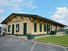
Albertville Depot |
|
000000001975-02-20-0000February 20, 1975
(#75000320) |
E. Main St.
34°15′59″N 86°12′22″W / 34.266389°N 86.206111°W / 34.266389; -86.206111 (Albertville Depot) |
Albertville |
Also known as the L&N Railroad Depot.
|
| 2 |
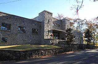
Company E of the 167th Infantry of the Alabama National Guard Armory |
|
000000002005-08-12-0000August 12, 2005
(#05000842) |
Rayburn Ave.
34°20′57″N 86°18′10″W / 34.349167°N 86.302778°W / 34.349167; -86.302778 (Company E of the 167th Infantry of the Alabama National Guard Armory) |
Guntersville |
|
| 3 |
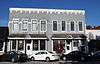
Downtown Guntersville Historic District |
|
000000002012-12-12-0000December 12, 2012
(#12001022) |
Gunter & Blount Aves., Ringold & Scott Sts.
34°21′32″N 86°17′36″W / 34.35875°N 86.2934°W / 34.35875; -86.2934 (Downtown Guntersville Historic District) |
Guntersville |
|
| 4 |
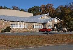
Guntersville City School |
|
000000002003-11-15-0000November 15, 2003
(#03001135) |
1120 Rayburn Ave.
34°21′04″N 86°18′10″W / 34.351111°N 86.302778°W / 34.351111; -86.302778 (Guntersville City School) |
Guntersville |
|
| 5 |
Guntersville Hydroelectric Project |
|
000000002016-07-26-0000July 26, 2016
(#16000432) |
3464 Snow Point Rd.
34°25′18″N 86°23′38″W / 34.421547°N 86.393967°W / 34.421547; -86.393967 (Guntersville Hydroelectric Project) |
Guntersville |
|
| 6 |
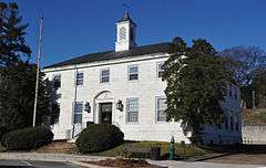
Guntersville Post Office Building |
|
000000002010-08-16-0000August 16, 2010
(#10000558) |
520 Gunter Ave.
34°21′28″N 86°17′42″W / 34.357856°N 86.29499°W / 34.357856; -86.29499 (Guntersville Post Office Building) |
Guntersville |
|
| 7 |
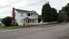
Albert G. Henry, Jr., House |
|
000000001989-04-13-0000April 13, 1989
(#89000291) |
308 Blount Ave.
34°21′38″N 86°17′31″W / 34.360556°N 86.291944°W / 34.360556; -86.291944 (Albert G. Henry, Jr., House) |
Guntersville |
|
| 8 |
Henry-Jordan House |
|
000000001979-09-04-0000September 4, 1979
(#79003351) |
301 Blount Ave.
34°21′39″N 86°17′28″W / 34.360833°N 86.291111°W / 34.360833; -86.291111 (Henry-Jordan House) |
Guntersville |
|
| 9 |
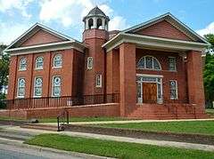
Julia Street Memorial United Methodist Church |
|
000000001999-07-22-0000July 22, 1999
(#99000855) |
302 Thomas Ave.
34°12′03″N 86°09′43″W / 34.200833°N 86.161944°W / 34.200833; -86.161944 (Julia Street Memorial United Methodist Church) |
Boaz |
|
| 10 |
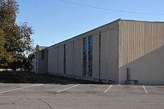
Kate Duncan Smith Daughters of the American Revolution School |
Upload image |
000000002002-10-02-0000October 2, 2002
(#02000478) |
6077 Main St.
34°32′00″N 86°15′11″W / 34.533333°N 86.253056°W / 34.533333; -86.253056 (Kate Duncan Smith Daughters of the American Revolution School) |
Grant |
|
| 11 |
Saratoga Victory Mill |
|
000000001984-04-12-0000April 12, 1984
(#84000659) |
1821 Gunter Ave.
34°20′23″N 86°18′33″W / 34.339722°N 86.309167°W / 34.339722; -86.309167 (Saratoga Victory Mill) |
Guntersville |
|
| 12 |
Snead Junior College Historic District |
|
000000001999-04-22-0000April 22, 1999
(#99000468) |
220 N. Walnut St., 308 W. Mann Ave., 201 College Ave., and 300 and 301 Elder St.
34°12′02″N 86°10′08″W / 34.200556°N 86.168889°W / 34.200556; -86.168889 (Snead Junior College Historic District) |
Boaz |
|
| 13 |
Thomas A. Snellgrove Homestead |
Upload image |
000000001996-02-23-0000February 23, 1996
(#96000167) |
5115 E. Mann Ave., 310 Mill Ave.
34°11′57″N 86°09′34″W / 34.199167°N 86.159444°W / 34.199167; -86.159444 (Thomas A. Snellgrove Homestead) |
Boaz |
|
| 14 |
U.S. Post Office |
|
000000001983-06-21-0000June 21, 1983
(#83002980) |
107 W. Main St.
34°16′05″N 86°12′34″W / 34.268185°N 86.209341°W / 34.268185; -86.209341 (U.S. Post Office) |
Albertville |
Currently serves as the Albertville Board of Education building.
|
| 15 |
Edward Fenns Whitman House |
Upload image |
000000001997-09-26-0000September 26, 1997
(#97001163) |
200 Thomas Ave.
34°12′04″N 86°09′48″W / 34.201111°N 86.163333°W / 34.201111; -86.163333 (Edward Fenns Whitman House) |
Boaz |
|
| [3] |
Name on the Register |
Image |
Date listed | Date removed |
Location |
City or town |
Summary |
|---|
| 1 |
Hotel Thompson |
Upload image |
000000001986-05-08-0000May 8, 1986
(#86001002) | 000000001989-05-11-0000May 11, 1989 |
104 First Ave. NE
|
Arab |
|
See also
References
- ↑ The latitude and longitude information provided in this table was derived originally from the National Register Information System, which has been found to be fairly accurate for about 99% of listings. For about 1% of NRIS original coordinates, experience has shown that one or both coordinates are typos or otherwise extremely far off; some corrections may have been made. A more subtle problem causes many locations to be off by up to 150 yards, depending on location in the country: most NRIS coordinates were derived from tracing out latitude and longitudes off of USGS topographical quadrant maps created under the North American Datum of 1927, which differs from the current, highly accurate WGS84 GPS system used by most on-line maps. Chicago is about right, but NRIS longitudes in Washington are higher by about 4.5 seconds, and are lower by about 2.0 seconds in Maine. Latitudes differ by about 1.0 second in Florida. Some locations in this table may have been corrected to current GPS standards.
- ↑ "National Register of Historic Places: Weekly List Actions". National Park Service, United States Department of the Interior. Retrieved on December 16, 2016.
- 1 2 Numbers represent an ordering by significant words. Various colorings, defined here, differentiate National Historic Landmarks and historic districts from other NRHP buildings, structures, sites or objects.
- ↑ The eight-digit number below each date is the number assigned to each location in the National Register Information System database, which can be viewed by clicking the number.
|
|---|
|
Lists
by county | | |
|---|
|
| Lists by city | |
|---|
|
| Other lists | |
|---|
|
|


.JPG)