| [3] |
Name on the Register |
Image |
Date listed[4] |
Location |
City or town |
Description |
|---|
| 1 |
David Rinehart Anthony House |
|
000000001982-04-02-0000April 2, 1982
(#82002015) |
307 Wilson Ave.
32°50′27″N 87°53′25″W / 32.840833°N 87.890278°W / 32.840833; -87.890278 (David Rinehart Anthony House) |
Eutaw |
Destroyed. Was located across from First Presbyterian Church. Site now occupied by a modern bank building.
|
| 2 |
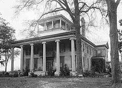
Boligee Hill |
|
000000001982-02-19-0000February 19, 1982
(#82002014) |
Southeast of Boligee
32°45′35″N 87°59′20″W / 32.759722°N 87.988889°W / 32.759722; -87.988889 (Boligee Hill) |
Boligee |
|
| 3 |
Gustave Braune House |
|
000000001982-04-02-0000April 2, 1982
(#82002016) |
236 Prairie Ave.
32°50′18″N 87°53′15″W / 32.838333°N 87.8875°W / 32.838333; -87.8875 (Gustave Braune House) |
Eutaw |
|
| 4 |
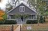
Capt. Nathan Carpenter House |
|
000000001999-07-23-0000July 23, 1999
(#99000793) |
2.5 miles southeast of Clinton
32°54′05″N 87°58′12″W / 32.901389°N 87.97°W / 32.901389; -87.97 (Capt. Nathan Carpenter House) |
Eutaw |
1852 Greek Revival plantation house.[5]
|
| 5 |
Samuel W. Cockrell House |
|
000000001982-12-06-0000December 6, 1982
(#82001618) |
210 Wilson Ave.
32°50′10″N 87°53′24″W / 32.836111°N 87.89°W / 32.836111; -87.89 (Samuel W. Cockrell House) |
Eutaw |
|
| 6 |
John Coleman House |
|
000000001982-12-06-0000December 6, 1982
(#82001617) |
1160 Mesopotamia St.
32°51′36″N 87°55′24″W / 32.86°N 87.923333°W / 32.86; -87.923333 (John Coleman House) |
Eutaw |
|
| 7 |
Coleman-Banks House |
|
000000001970-12-18-0000December 18, 1970
(#70000102) |
430 Springfield Ave.
32°50′34″N 87°53′15″W / 32.842778°N 87.8875°W / 32.842778; -87.8875 (Coleman-Banks House) |
Eutaw |
|
| 8 |
Attoway R. Davis Home |
|
000000001982-04-02-0000April 2, 1982
(#82002017) |
305 Main St.
32°50′27″N 87°53′27″W / 32.840833°N 87.890833°W / 32.840833; -87.890833 (Attoway R. Davis Home) |
Eutaw |
|
| 9 |
John W. Elliott House |
Upload image |
000000001982-04-02-0000April 2, 1982
(#82002018) |
244 Prairie Ave.
32°50′19″N 87°53′15″W / 32.838611°N 87.8875°W / 32.838611; -87.8875 (John W. Elliott House) |
Eutaw |
Also known as the Wilson House, built by John W. Elliott about 1850. Has been moved elsewhere since listing, site is now a parking lot.[6]
|
| 10 |
First Presbyterian Church |
|
000000001974-12-16-0000December 16, 1974
(#74000411) |
Main St. and Wilson Ave.
32°50′28″N 87°53′26″W / 32.841111°N 87.890556°W / 32.841111; -87.890556 (First Presbyterian Church) |
Eutaw |
|
| 11 |
Glenville |
|
000000001982-04-02-0000April 2, 1982
(#82002019) |
200 Scears Dr.
32°50′14″N 87°54′22″W / 32.837222°N 87.906111°W / 32.837222; -87.906111 (Glenville) |
Eutaw |
|
| 12 |
Rev. John H. Gray House |
|
000000001982-04-02-0000April 2, 1982
(#82002020) |
709 Mesopotamia St.
32°50′56″N 87°54′03″W / 32.848889°N 87.900833°W / 32.848889; -87.900833 (Rev. John H. Gray House) |
Eutaw |
|
| 13 |
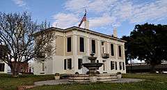
Greene County Courthouse |
|
000000001971-03-24-0000March 24, 1971
(#71000098) |
Courthouse Sq.
32°50′28″N 87°53′13″W / 32.841111°N 87.886944°W / 32.841111; -87.886944 (Greene County Courthouse) |
Eutaw |
|
| 14 |
Greene County Courthouse Square District |
|
000000001979-12-31-0000December 31, 1979
(#79000385) |
U.S. Route 11 and State Route 7
32°50′25″N 87°53′17″W / 32.840278°N 87.888056°W / 32.840278; -87.888056 (Greene County Courthouse Square District) |
Eutaw |
|
| 15 |
Benjamin D. Gullett House |
|
000000001982-04-02-0000April 2, 1982
(#82002021) |
317 Main St.
32°50′25″N 87°53′24″W / 32.840278°N 87.89°W / 32.840278; -87.89 (Benjamin D. Gullett House) |
Eutaw |
|
| 16 |
Stephen Fowler Hale House |
|
000000001982-04-02-0000April 2, 1982
(#82002022) |
223 Wilson Ave.
32°50′16″N 87°53′27″W / 32.837778°N 87.890833°W / 32.837778; -87.890833 (Stephen Fowler Hale House) |
Eutaw |
|
| 17 |
William C. Jones House |
|
000000001982-04-02-0000April 2, 1982
(#82002023) |
507 Mesopotamia St.
32°50′37″N 87°53′44″W / 32.843611°N 87.895556°W / 32.843611; -87.895556 (William C. Jones House) |
Eutaw |
|
| 18 |
Kirkwood |
|
000000001976-05-17-0000May 17, 1976
(#76000327) |
111 Kirkwood Dr.
32°50′47″N 87°53′45″W / 32.846389°N 87.895833°W / 32.846389; -87.895833 (Kirkwood) |
Eutaw |
|
| 19 |
Dr. Willis Meriwether House |
|
000000001982-04-02-0000April 2, 1982
(#82002024) |
243 Wilson Ave.
32°50′21″N 87°53′26″W / 32.839167°N 87.890556°W / 32.839167; -87.890556 (Dr. Willis Meriwether House) |
Eutaw |
|
| 20 |
Samuel R. Murphy House |
|
000000001982-04-02-0000April 2, 1982
(#82002025) |
1150 Mesopotamia St.
32°51′22″N 87°54′26″W / 32.856111°N 87.907222°W / 32.856111; -87.907222 (Samuel R. Murphy House) |
Eutaw |
|
| 21 |
William Perkins House |
|
000000001982-04-02-0000April 2, 1982
(#82002026) |
89 Spencer St.
32°50′18″N 87°53′21″W / 32.838333°N 87.889167°W / 32.838333; -87.889167 (William Perkins House) |
Eutaw |
|
| 22 |
William F. Pierce House |
|
000000001983-11-17-0000November 17, 1983
(#83003446) |
309 Womack Ave.
32°50′30″N 87°53′46″W / 32.841667°N 87.896111°W / 32.841667; -87.896111 (William F. Pierce House) |
Eutaw |
|
| 23 |
Littleberry Pippen House |
|
000000001982-04-02-0000April 2, 1982
(#82002027) |
431 Springfield Ave.
32°50′34″N 87°53′17″W / 32.842778°N 87.888056°W / 32.842778; -87.888056 (Littleberry Pippen House) |
Eutaw |
|
| 24 |
Edwin Reese House |
|
000000001982-04-02-0000April 2, 1982
(#82002028) |
244 Wilson Ave.
32°50′23″N 87°53′23″W / 32.839722°N 87.889722°W / 32.839722; -87.889722 (Edwin Reese House) |
Eutaw |
|
| 25 |
William A. Rogers House |
|
000000001982-04-02-0000April 2, 1982
(#82002029) |
1149 Mesopotamia St.
32°51′22″N 87°54′22″W / 32.856111°N 87.906111°W / 32.856111; -87.906111 (William A. Rogers House) |
Eutaw |
|
| 26 |
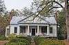
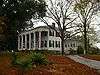
Rosemount |
|
000000001971-05-27-0000May 27, 1971
(#71000099) |
1 mile (1.6 km) northwest of Forkland
32°40′16″N 87°54′28″W / 32.671111°N 87.907778°W / 32.671111; -87.907778 (Rosemount) |
Forkland |
|
| 27 |
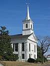
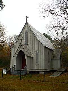
St. John's-In-The-Prairie |
|
000000001975-11-20-0000November 20, 1975
(#75000313) |
State Route 4
32°38′51″N 87°52′54″W / 32.6475°N 87.881667°W / 32.6475; -87.881667 (St. John's-In-The-Prairie) |
Forkland |
|
| 28 |
Phillip Schoppert House |
|
000000001982-04-02-0000April 2, 1982
(#82002030) |
230 Prairie Ave.
32°50′17″N 87°53′15″W / 32.838056°N 87.8875°W / 32.838056; -87.8875 (Phillip Schoppert House) |
Eutaw |
|
| 29 |
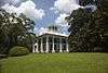
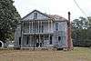
Thornhill |
|
000000001984-05-10-0000May 10, 1984
(#84000618) |
Northwest of Forkland
32°41′14″N 87°55′54″W / 32.687222°N 87.931667°W / 32.687222; -87.931667 (Thornhill) |
Forkland |
|
| 30 |
Iredell P. Vaughn House |
|
000000001982-04-02-0000April 2, 1982
(#82002031) |
409 Wilson Ave.
32°50′31″N 87°53′27″W / 32.841944°N 87.890833°W / 32.841944; -87.890833 (Iredell P. Vaughn House) |
Eutaw |
|
| 31 |
William Peter Webb House |
|
000000001982-04-02-0000April 2, 1982
(#82002032) |
401 Main St.
32°50′30″N 87°53′33″W / 32.841667°N 87.8925°W / 32.841667; -87.8925 (William Peter Webb House) |
Eutaw |
|
| 32 |
Asa White House |
|
000000001982-04-02-0000April 2, 1982
(#82002033) |
314 Mesopotamia St.
32°50′35″N 87°53′29″W / 32.843056°N 87.891389°W / 32.843056; -87.891389 (Asa White House) |
Eutaw |
|
| 33 |
William B. Wills House |
|
000000001983-09-22-0000September 22, 1983
(#83002969) |
108 Ashby Dr.
32°50′50″N 87°53′43″W / 32.847222°N 87.895278°W / 32.847222; -87.895278 (William B. Wills House) |
Eutaw |
|
| 34 |
Catlin Wilson House |
|
000000001982-04-02-0000April 2, 1982
(#82002034) |
237 Wilson Ave.
32°50′20″N 87°53′26″W / 32.838889°N 87.890556°W / 32.838889; -87.890556 (Catlin Wilson House) |
Eutaw |
|
| 35 |
Daniel R. Wright House |
|
000000001982-04-02-0000April 2, 1982
(#82002035) |
501 Pickens St.
32°50′34″N 87°53′00″W / 32.842778°N 87.883333°W / 32.842778; -87.883333 (Daniel R. Wright House) |
Eutaw |
|


.jpg)