Bardwell Creek
| Bardwell Creek | |
| Watercourse[1] | |
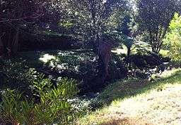 Bardwell Creek, near Ellerslie Road Bexley North. | |
| Country | Australia |
|---|---|
| State | New South Wales |
| IBRA | Sydney Basin, St George |
| District | Southern Sydney |
| Municipalities | Bayside, Georges River |
| Part of | Cooks River catchment |
| Source | |
| - location | near Beverly Hills railway station |
| Mouth | confluence with Wolli Creek |
| - location | Turrella |
| Length | 4 km (2 mi) |
| Basin | 6.36 km2 (2 sq mi) |
| Nature Reserve | Wolli Creek Regional Park |
| [1] | |
Bardwell Creek, an urban watercourse of the Cooks River catchment, is located in the southern suburbs of Sydney, in New South Wales, Australia.
Course and features
Bardwell Creek rises in Georges River local government area, near Hurstville and flows in a north-easterly direction through the suburbs of Bexley, Bexley North, Bardwell Park, and Turrella in the Bayside local government area, where it makes its confluence with Wolli Creek, where it forms the border between the suburbs of Bardwell Park and Turrella.[2] The upper reaches of the Creek are a piped drainage system, which becomes an open concrete channel at Croydon Road in the Bexley Golf Course. The total catchment area of Bardwell Creek is 6.36 square kilometres (2.46 sq mi).[3]
See also
References
- 1 2 "Bardwell Creek". Geographical Names Register (GNR) of NSW. Geographical Names Board of New South Wales. Retrieved 9 April 2013.
- ↑ "Bardwell Creek Facts and Figures". Local Waterways and Catchments. Rockdale City Council. 2012. Retrieved 3 June 2012.
- ↑ "Natural Environment: Water: Cooks River catchment" (PDF). Hurstville Snapshot. Hurstville City Council. 2004. p. 72. Retrieved 3 June 2012.
External links
- "Cooks River catchment" (map). Office of Environment and Heritage. Government of New South Wales.
Coordinates: 33°57′S 151°07′E / 33.950°S 151.117°E