Allyn River
| Allyn | |
| River | |
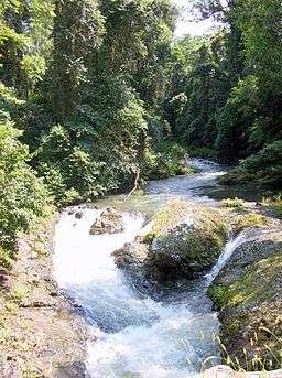 Allyn River, surrounded by sub tropical rainforest | |
| Country | Australia |
|---|---|
| State | New South Wales |
| Regions | NSW North Coast (IBRA), Hunter |
| Local government area | Dungong |
| Part of | Hunter River catchment |
| Tributaries | |
| - left | Chads Creek, Stony Creek (Dungog, New South Wales), Lewinsbrook Creek, McIntyre Creek, Mirari Creek |
| - right | Masseys Creek, Bucks Creek |
| Town | East Gresford |
| Source | Allyn Range, Barrington Tops |
| - location | near Careys Peak |
| - elevation | 655 m (2,149 ft) |
| - coordinates | 32°21′42.9″S 151°31′55.668″E / 32.361917°S 151.53213000°E |
| Mouth | Paterson River |
| - location | Vacy |
| - elevation | 15 m (49 ft) |
| - coordinates | 32°3′43.26″S 151°24′57″E / 32.0620167°S 151.41583°ECoordinates: 32°3′43.26″S 151°24′57″E / 32.0620167°S 151.41583°E |
| Length | 82 km (51 mi) |
 | |
| Wikimedia Commons: Allyn River | |
| [1] | |
Allyn River, a perennial stream[2] of the Hunter River catchment, is located in the Hunter region of New South Wales, Australia.
Course
Allyn River rises on Allyn Range, on the slopes of the Gondwana Rainforests Barrington Tops, west of Careys Peak, and flows generally southeast, joined by seven minor tributaries, before reaching its confluence with the Paterson River near Vacy; descending 640 metres (2,100 ft) over its 82-kilometre (51 mi) course.[1]
The course of the river flows through World Heritage listed high altitude rainforest, noted for its Antarctic Beech; and then through lower altitude subtropical rainforest, including trees such as Red Cedar and Small leaf fig.[3] Some of the River Oak growing beside the stream are over 50 metres (160 ft) in height. Logging has been practiced in the area since the 1820s.[3]
History
The Allyn River valley is the traditional territory of the Gringai clan of the Wonnarua people,[4][5] a group of indigenous people of Australia.
See also
References
- 1 2 "Map of Allyn River, NSW". Bonzle Digital Atlas of Australia. Retrieved 25 February 2013.
- ↑ "Allyn River". Geographical Names Register (GNR) of NSW. Geographical Names Board of New South Wales. Retrieved 27 February 2013.
- 1 2 Allyn River Visitor's Guide. State Forests of New South Wales. Government of New South Wales. February 2000.
- ↑ "Caergwrle, Allynbrook". Discover people and places. State Library of New South Wales. 2011. Retrieved 13 May 2012.
- ↑ "Strategic Plan 2009–2019" (PDF). Wonnarua Nation Aboriginal Corporation. Retrieved 13 May 2012.
External links
- "Hunter River catchment" (map). Office of Environment and Heritage. Government of New South Wales.
River systems and rivers of Hunter-Central Rivers catchment, New South Wales, Australia | |||||||
|---|---|---|---|---|---|---|---|
| |||||||
| |||||||
| |||||||
|