Amherst, Nova Scotia
| Amherst | |||
|---|---|---|---|
| Town | |||
|
Downtown Amherst, Nova Scotia in the morning. View on Google Street View | |||
| |||
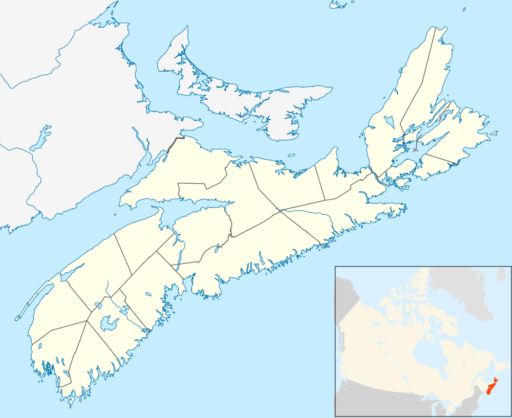 Amherst Location of Amherst, Nova Scotia | |||
| Coordinates: 45°49′N 64°13′W / 45.817°N 64.217°WCoordinates: 45°49′N 64°13′W / 45.817°N 64.217°W | |||
| Country | Canada | ||
| Province | Nova Scotia | ||
| County | Cumberland | ||
| Founded | 1764 | ||
| Incorporated | December 18, 1889 | ||
| Government | |||
| • Mayor | David Kogon | ||
| • Deputy Mayor | Terry Rhindress | ||
| • Councillors |
List of Members
| ||
| • MLA | Terry Farrell (Liberal) | ||
| • MP | Bill Casey (Liberal) | ||
| Area[1] | |||
| • Land | 12.02 km2 (4.64 sq mi) | ||
| Elevation | 22.11 m (72.54 ft) | ||
| Population (2011)[1][2] | |||
| • Town | 9,717 | ||
| • Density | 790.7/km2 (2,048/sq mi) | ||
| • Urban | 9,547 | ||
| • Change 2006–11 |
| ||
| • Census Ranking | 401 of 5,008 | ||
| Demonym(s) | Amherstonian | ||
| Time zone | AST (UTC−4) | ||
| • Summer (DST) | ADT (UTC−3) | ||
| Postal code(s) | B4H | ||
| Area code(s) |
| ||
| Access Routes |
| ||
| Dwellings | 4,410 | ||
| Median Income* | $36,539 CDN | ||
| NTS Map | 021H16 | ||
| GNBC Code | CAAOO | ||
| Website | www.amherst.ca | ||
| |||


Amherst (2011 population 9,717; UA population 9,547[1]) is a town in northwestern Cumberland County, Nova Scotia, Canada.
Located at the northeast end of the Cumberland Basin, an arm of the Bay of Fundy, Amherst is strategically situated on the eastern boundary of the Tantramar Marshes 3 kilometres east of the interprovincial border with New Brunswick and 65 kilometres southeast of the city of Moncton. It is also located 60 kilometres southwest of the New Brunswick abutment of the Confederation Bridge to Prince Edward Island at Cape Jourimain.
Amherst is the shire town and largest population centre in Cumberland County.
History

According to Dr. Graham P. Hennessey, "The Micmac name was Nemcheboogwek meaning 'going up rising ground', in reference to the higher land to the east of the Tantramar Marshes. The Acadians who settled here as early as 1672 called the village Les Planches. The village was later renamed Amherst by Colonel Joseph Morse in honour of Lord Amherst, the commander-in-chief of the British Army in North America during the Seven Years' War."
The town was first settled in 1764 by immigrants from Yorkshire following the expulsion of the Acadians, with the original settlement being located three kilometres southwest of the present town on the shore of the Bay of Fundy. These settlers were joined by United Empire Loyalists (Loyalists who fled the American colonies during the American Revolution). A mill was built on the current townsite, and the residents moved there to be closer to work.
During the 19th century, Amherst became an important regional centre for shipbuilding and other services to outlying communities. An indication of the town's importance in Canadian history is seen with its four Fathers of Confederation: Edward B. Chandler, Robert B. Dickey, Jonathan McCully, and Sir Charles Tupper.
During the late 19th century, local industrialists and entrepreneurs constructed many fine Victorian and Edwardian homes along Victoria Street East, leading toward the farming hamlet of East Amherst. Many notable residents have lived in this district, including Tupper, Senator Thomas R. Black, the Barker Family, the Lamy Family, the Pugsley Family and Mary (Molly) Simmons Critchley. Amherst gained brief notoriety in the late 19th century as the location of alleged poltergeist phenomena afflicting Amherst resident Esther Cox in 1878 and 1879, which became known as the Great Amherst Mystery after the publication of a popular book on the affair.[3]

Amherst experienced unprecedented industrialization in the late 1870s after the Intercolonial Railway of Canada constructed its main line from Halifax to Quebec through the town in 1872. The location of the railway line away from the Bay of Fundy coast further consolidated the town at its present location as industry and commercial activity centred around this important transportation link. The economic boom created by the arrival of the Intercolonial Railway lasted through World War I and numerous foundries, factories and mills opened, giving rise to the nickname "Busy Amherst".
In 1908, the manufacturing output of Amherst's industries was not exceeded by any centre in the Maritime Provinces. Many of the fine old buildings along Victoria Street are considered industrial artifacts because they were constructed during a period of tremendous industry growth. Local contractors employed local craftsmen, who used local materials. Notice the emphasis on sandstone and brick, both locally produced and delightful detail which reflects the skilled craftsmanship prevalent in the 19th century.
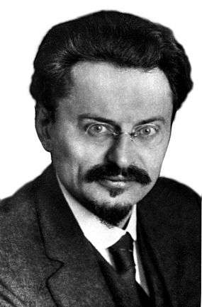
Amherst's prosperity would not last as the failed economic policies of the federal and provincial governments, coupled with World War I, saw the town's industrial economy begin a slow decline during the 1910s. A Prisoner-of-war camp was set up at Malleable Iron Foundry in Amherst, Nova Scotia from April 1915 to September 1919.[4] Amherst hosted a prisoner of war detention centre during World War I, and Russian revolutionary Leon Trotsky was incarcerated there for one month after he was arrested in Halifax, Nova Scotia in April 1917.[5][6]
During the Amherst general strike in 1919, worker unrest over social and economic conditions led to mass protests in sympathy with the Winnipeg general strike.
The eventual closure of companies such as Robb Engineering & Manufacturing (purchased by Canada Car and Foundry and then closed) and Amherst Pianos, among others led to a resignation of lost dreams as the town was overtaken by other newer manufacturing centres in central Canada during the 20th century. Amherst had a modest-sized industrial park constructed during the 1960s when the Trans-Canada Highway was being developed. Today the majority of the town's major employers are located there, including PolyCello and IMP Aerospace.
During World War II, the Royal Canadian Navy named a Flower class corvette HMCS Amherst.
The town is currently served by Via Rail's Halifax-to-Montreal train Ocean.

Businesses
Amherst is the retail centre for Cumberland County and the southeastern part of Westmorland County (New Brunswick). The town has several big box stores, including Walmart, Sobeys, Atlantic Superstore, Canadian Tire, Kent Building Supplies, Giant Tiger and Dollarama in addition to several fast food restaurants and auto dealerships. Shoppers Drug Mart was the town's anchor pharmacy retail until its closure on October 8, 2015 due to the long periods of declining profits and change of shopping habits. Zellers was a long time anchor store in the area until the purchase of the majority of the chain by Target which promptly announced the closure of many Zellers locations in smaller centers such as Amherst. There are also smaller independent retailers and restaurants in the downtown area, situated among various historic buildings. The town's location on Highway 104 (part of the Trans-Canada Highway) has transformed South Albion Street and Robert Angus Drive into a highway service centre. Liberty Enterprises Limited, started in 1973, operates a brass and aluminum foundry.[7]
Sports
Amherst is home of the Amherst Ramblers, a Junior A Hockey League team from the Maritime Hockey League. All home games are played out of the 2,500 seat Amherst Stadium. The season usually runs from mid-September to early March every year. The Ramblers draw some of the largest crowds in the Maritime Hockey League, and have placed third in average attendance over the past few years. They won the Centennial Cup in 1993.
Amherst is home to a popular running club known as the 'Amherst Striders' that are recognized at almost every race in the Maritimes. Amherst Striders meet 3 to 4 times a week, do not charge any membership fees and open to anyone interested in running and living a healthy lifestyle.
Every August, Amherst hosts an eight-team little league baseball tournament, featuring four teams from New England.
Climate
Amherst experiences a humid continental climate (Dfb). The highest temperature ever recorded was 34.4 °C (94 °F) on 18 August 1935. The coldest temperature ever recorded was −37.2 °C (−35 °F) on 18 February 1922.[8]
| Climate data for Nappan, 1981−2010 normals, extremes 1890−present[lower-alpha 1] | |||||||||||||
|---|---|---|---|---|---|---|---|---|---|---|---|---|---|
| Month | Jan | Feb | Mar | Apr | May | Jun | Jul | Aug | Sep | Oct | Nov | Dec | Year |
| Record high °C (°F) | 16.8 (62.2) |
16.2 (61.2) |
24.2 (75.6) |
26.1 (79) |
30.0 (86) |
31.7 (89.1) |
32.7 (90.9) |
34.4 (93.9) |
32.2 (90) |
27.0 (80.6) |
23.5 (74.3) |
18.5 (65.3) |
34.4 (93.9) |
| Average high °C (°F) | −2.7 (27.1) |
−1.4 (29.5) |
2.5 (36.5) |
8.8 (47.8) |
15.7 (60.3) |
20.7 (69.3) |
24.0 (75.2) |
23.8 (74.8) |
19.5 (67.1) |
13.3 (55.9) |
6.8 (44.2) |
1.0 (33.8) |
11.0 (51.8) |
| Daily mean °C (°F) | −7.7 (18.1) |
−6.5 (20.3) |
−2.1 (28.2) |
4.1 (39.4) |
10.2 (50.4) |
15.0 (59) |
18.5 (65.3) |
18.2 (64.8) |
14.2 (57.6) |
8.5 (47.3) |
3.0 (37.4) |
−3.4 (25.9) |
6.0 (42.8) |
| Average low °C (°F) | −12.6 (9.3) |
−11.5 (11.3) |
−6.8 (19.8) |
−0.6 (30.9) |
4.6 (40.3) |
9.2 (48.6) |
12.9 (55.2) |
12.5 (54.5) |
8.9 (48) |
3.6 (38.5) |
−0.8 (30.6) |
−7.7 (18.1) |
1.0 (33.8) |
| Record low °C (°F) | −36.7 (−34.1) |
−37.2 (−35) |
−29.5 (−21.1) |
−21.1 (−6) |
−6.7 (19.9) |
−3.3 (26.1) |
−1.1 (30) |
0.0 (32) |
−4.5 (23.9) |
−12.2 (10) |
−18.9 (−2) |
−34.0 (−29.2) |
−37.2 (−35) |
| Average precipitation mm (inches) | 106.1 (4.177) |
82.7 (3.256) |
104.7 (4.122) |
91.6 (3.606) |
100.7 (3.965) |
82.6 (3.252) |
89.0 (3.504) |
74.4 (2.929) |
102.1 (4.02) |
102.8 (4.047) |
110.8 (4.362) |
107.3 (4.224) |
1,154.8 (45.465) |
| Average rainfall mm (inches) | 47.9 (1.886) |
36.1 (1.421) |
49.1 (1.933) |
62.7 (2.469) |
91.7 (3.61) |
79.6 (3.134) |
89.0 (3.504) |
74.4 (2.929) |
98.4 (3.874) |
97.2 (3.827) |
95.9 (3.776) |
64.2 (2.528) |
886.0 (34.882) |
| Average snowfall cm (inches) | 62.4 (24.57) |
51.2 (20.16) |
49.9 (19.65) |
23.9 (9.41) |
5.2 (2.05) |
0.0 (0) |
0.0 (0) |
0.0 (0) |
0.0 (0) |
0.2 (0.08) |
15.6 (6.14) |
45.8 (18.03) |
254.2 (100.08) |
| Average precipitation days (≥ 0.2 mm) | 14.3 | 11.9 | 13.2 | 13.0 | 14.7 | 14.2 | 13.1 | 12.3 | 11.7 | 13.6 | 15.1 | 14.0 | 161.2 |
| Average rainy days (≥ 0.2 mm) | 5.3 | 4.9 | 6.9 | 10.0 | 13.8 | 13.6 | 12.7 | 12.1 | 11.4 | 12.8 | 12.3 | 6.9 | 122.6 |
| Average snowy days (≥ 0.2 cm) | 10.4 | 8.4 | 7.3 | 3.6 | 0.52 | 0.0 | 0.0 | 0.0 | 0.0 | 0.09 | 2.8 | 7.6 | 40.7 |
| Mean monthly sunshine hours | 93.9 | 108.6 | 137.9 | 146.5 | 186.0 | 208.5 | 229.7 | 218.0 | 161.1 | 130.7 | 76.2 | 79.3 | 1,776.1 |
| Percent possible sunshine | 33.1 | 37.2 | 37.4 | 36.2 | 40.2 | 44.4 | 48.4 | 49.8 | 42.7 | 38.4 | 26.7 | 29.3 | 38.6 |
| Source: Environment Canada[8][9][10][11][12][13] | |||||||||||||
Demographics
| Historical populations | ||
|---|---|---|
| Year | Pop. | ±% |
| 1871 | 1,839 | — |
| 1881 | 2,274 | +23.7% |
| 1891 | 3,781 | +66.3% |
| 1901 | 4,964 | +31.3% |
| 1911 | 8,973 | +80.8% |
| 1921 | 9,998 | +11.4% |
| 1931 | 7,450 | −25.5% |
| 1941 | 8,620 | +15.7% |
| 1951 | 9,870 | +14.5% |
| 1956 | 10,301 | +4.4% |
| 1961 | 10,788 | +4.7% |
| 1971 | 9,966 | −7.6% |
| 1981 | 9,684 | −2.8% |
| 1986 | 9,671 | −0.1% |
| 1991 | 9,742 | +0.7% |
| 1996 | 9,669 | −0.7% |
| 2001 | 9,470 | −2.1% |
| 2006 | 9,505 | +0.4% |
| 2011 | 9,717 | +2.2% |
| [14][15][16][17][18][19][20][21][22][23] | ||
| Canada 2006 Census[24] | ||
|---|---|---|
| Ethnic Origin | Population | % of Total Population |
| Canadian | 4,215 | 45.4 |
| English | 3,625 | 39.1 |
| Scottish | 2,745 | 29.6 |
| Irish | 2,040 | 22.0 |
| French | 1,840 | 19.8 |
| German | 655 | 7.1 |
| Dutch (Netherlands) | 385 | 4.1 |
Notable citizens
- Willard Boyle, co-inventor of the charge-coupled device (CCD), for which he shared a 2009 Nobel Prize in Physics
- Alfred Paul Rogers, American Orthodontist
- Roger Stuart Bacon, former Premier of Nova Scotia
- Bill Casey, politician
- Edward Barron Chandler, politician
- Robert C. Coates, politician
- Alex Colville, Painter
- George Barton Cutten, university president
- Mac Davis, NHL player
- Robert Barry Dickey, politician
- Leslie Feist, musician
- Sandy Goss, Olympian
- Rocky Johnson, professional wrestler, WWE Hall of Fame inductee, father of Dwayne "The Rock" Johnson
- Jonathan McCully, politician
- Willard M. Mitchell, artist and architect
- James Pearson Newcomb, Secretary of State of Texas
- William Thomas Pipes, former Premier of Nova Scotia
- Edgar Nelson Rhodes, former Premier of Nova Scotia
- Bill Riley, third Black player to play in the NHL
- Norman McLeod Rogers, politician
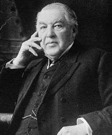
- Sir Charles Tupper, 6th Prime Minister of Canada
Media
Television
Amherst is served locally by EastLink TV. The station also serves the communities of Springhill, Oxford, and others in the county, as well as Sackville, New Brunswick.
Radio
Newspapers
- Amherst News (weekly)
- Citizen - Record (weekly)
See also
References
- 1 2 3 2006 Statistics Canada Community Profile: Amherst, Nova Scotia
- ↑ Statistics Canada Population and dwelling counts, for Canada and census subdivisions (municipalities), 2006 and 2001 censuses - 100% data
- ↑ Hubbell, Walter (1882). The Haunted House: A True Ghost Story. New York: Brentano.
- ↑ "Internment Camps in Canada during the First and Second World Wars, Library and Archives Canada".
- ↑
- ↑
- ↑ ic.gc.ca: "Canadian Company Capabilities - Complete profile: Liberty Enterprises Limited
- 1 2 "Nappan CDA, Nova Scotia". 1981–2010 Canadian Climate Normals. Environment Canada. Retrieved March 24, 2015.
- ↑ "Daily Data Report for December 2008". Canadian Climate Data. Environment Canada. Retrieved 2 September 2016.
- ↑ "Daily Data Report for October 2010". Canadian Climate Data. Environment Canada. Retrieved 2 September 2016.
- ↑ "Daily Data Report for March 2012". Canadian Climate Data. Environment Canada. Retrieved 2 September 2016.
- ↑ "Daily Data Report for February 2016". Canadian Climate Data. Environment Canada. Retrieved 2 September 2016.
- ↑ "Nappan Auto". Canadian Climate Data. Environment Canada. Retrieved 2 September 2016.
- ↑ , Censuses 1871-1941
- ↑ , Census 1941-1951
- ↑ 104.pdf, Canada Year Book 1932
- ↑ 140.pdf, Canada Year Book 1955
- ↑ 126.pdf, Canada Year Book 1957–58
- ↑ , Canada Year Book 1967
- ↑ , E-STAT Table
- ↑ , 1996 Census of Canada: Electronic Area Profiles
- ↑ , Community Profiles from the 2006 Census, Statistics Canada
- ↑ , Census Profile - Census Subdivision
- ↑ , Ethnocultural Portrait from the 2006 Census, Statistics Canada
Notes
External links
| Wikivoyage has a travel guide for Amherst (Nova Scotia). |
- Town of Amherst
- Environment Canada - Amherst Weather
- Cumberland County Genealogical Society - Amherst - The Local Newspaper Compares Amherst and its newspaper in 1939 and 1914.
 |
Fort Lawrence on Highway Sackville, New Brunswick |
Tantramar Marsh | Tyndal Road on Route |
|
| Cobequid Bay | |
Warren on Trunk | ||
| ||||
| | ||||
| Amherst Point Joggins on Route |
Upper Nappan on Trunk Parrsboro on Trunk |
Brookdale on Route Springhill on Trunk |
| Counties | |
|---|---|
| Economic Regions | |
| Regional municipalities | |
| Municipal districts | |
| Towns | |
| Incorporated villages | |
| Lists | |
| |