Yarmouth, Nova Scotia
| Yarmouth | |||
|---|---|---|---|
| Town | |||
|
Main Street Yarmouth | |||
| |||
| Nickname(s): "The Gateway to Nova Scotia" | |||
|
Motto: "Progress" "On the Edge of Everywhere" | |||
 Yarmouth Location of Yarmouth, Nova Scotia | |||
| Coordinates: 43°50′10″N 66°07′03″W / 43.83611°N 66.11750°WCoordinates: 43°50′10″N 66°07′03″W / 43.83611°N 66.11750°W | |||
| Country |
| ||
| Province |
| ||
| County | Yarmouth | ||
| Founded | June 9, 1761 | ||
| Incorporated | August 6, 1890 | ||
| Electoral Districts Federal |
West Nova | ||
| Provincial | Yarmouth | ||
| Government | |||
| • Type | Town Council | ||
| • Mayor | Pam Mood | ||
| • Deputy Mayor | Phil Mooney | ||
| • Councillors |
List of Members
| ||
| • MLA | Zach Churchill (L) | ||
| • MP | Colin Fraser (L) | ||
| Area[1] | |||
| • Land | 10.56 km2 (4.08 sq mi) | ||
| Highest elevation | 43 m (141 ft) | ||
| Lowest elevation | 0 m (0 ft) | ||
| Population (2011)[1] | |||
| • Total | 6,761 | ||
| • Density | 640.3/km2 (1,658/sq mi) | ||
| • Change (2006-11) |
| ||
| Time zone | AST (UTC-4) | ||
| • Summer (DST) | ADT (UTC-3) | ||
| Postal code(s) | B5A | ||
| Area code | 902 & 782 | ||
| Highways |
| ||
| Dwellings | 3,323 | ||
| Median Income* | $31,584 CDN | ||
| NTS Map | 020O16 | ||
| GNBC Code | CBPIB | ||


Yarmouth is a port town located on the Bay of Fundy in southwestern Nova Scotia, Canada. Yarmouth is the shire town of Yarmouth County and is largest population centre in the region.
Long connected to fishing due to its proximity to Georges Bank, the town is located in the heart of the world's largest lobster fishing grounds and as a result receives Canada's largest lobster landings each year.[2]
History
Originally inhabited by the Mi'kmaq, the region was known as "Keespongwitk" meaning "Lands End" due to its geographic isolation being located at the southwestern tip of the Nova Scotia peninsula.[3][4]
The region may have possibly been visited by Leif Ericson. An object known as the Yarmouth Runic Stone was found at the nearby village of Overton in 1812. It was interpreted by some to have been carved by Ericson, while others feel the markings are natural scratches gradually enhanced over the years. The stone is preserved at the Yarmouth County Museum & Archives.
European settlement
The region was visited in 1604 by Samuel de Champlain, who named it "Cap-Fourchu", meaning "forked or cloven cape."[4] The first Europeans to make a settlement on these shores were the French Acadians. They set up a small fishing settlement known as "Tebouque" in the mid 17th century and by 1750 the population was 50 people.[5] During the Seven Years' War, New England Planters settled at what is now the town of Yarmouth in 1759; the grantees were from Yarmouth, Massachusetts and they requested that Yarmouth be named after their former home.[6] Yarmouth was founded on June 9, 1761 when a ship carrying three families arrived from Sandwich, Massachusetts. The ship carried the families of Sealed Landers, Ebenezer Ellis, and Moses Perry.[7] Following the war, Acadians originally from the Grand-Pré district who returned from exile in 1767 settled in the Yarmouth area. After the American Revolution, substantial numbers of United Empire Loyalists arrived in 1785.
Shipbuilding

Through the 19th century the town was a major shipbuilding centre, at one point boasting more registered tonnage per capita than any other port in the world.[8] From 1874 to 1885, Yarmouth was the second largest port of registry in Canada following Saint John, New Brunswick. In 1878, Yarmouth's tonnage peaked at 453 vessels aggregating 166,623 tons, and in 1879, the town had the second largest registered tonnage in Canada.[9][10]
Yarmouth ships were found in most major ports throughout the world at this time, including ships noted for courageous crews such as the ship Research in 1861 and ships noted for great size such as the ship County of Yarmouth in 1884, one of the largest wooden hull ships ever built in Canada. John Patch, the son of a Yarmouth sea captain, developed and built one of the first modern screw propeller in 1832 (4 years before John Ericsson's patent). First demonstrated in Yarmouth Harbour during the summer of 1833, Patch was unsuccessful in a patent application in that year, but he continued to improve his propeller and received an American patent in 1849[11] which drew praise in American scientific circles.[12] However, by 1849 there were multiple competing versions of the screw propeller. Patch never received money or recognition and died a poor man at Yarmouth in 1861.[13]
The town of Yarmouth was incorporated on August 6, 1890.[4]
Railways
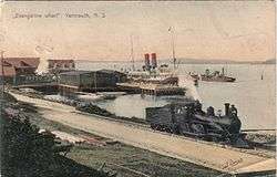
As wooden shipbuilding declined in the late 19th century, Yarmouth's shipowners re-invested their capital into factories, iron-hulled steamships, and railways. The town's first railway was the locally owned Western Counties Railway which was built from Yarmouth to Digby in the 1870s. It eventually was merged into the Dominion Atlantic Railway (DAR), with a network extending into the Annapolis Valley, Halifax and Truro; the DAR later became a subsidiary of Canadian Pacific Railway (CPR). The Halifax and Southwestern Railway was built along the south shore linking Yarmouth with Shelburne, Liverpool, Bridgewater and Halifax in the early 20th century; the H&SW was eventually merged into the Canadian National Railway (CNR). While iron-hulled steamships had led to the decline of Yarmouth's once-thriving wooden shipbuilding industry, they also made the port a vital connection between Nova Scotia's rail lines and steamships destined for Boston and New York. Rail services were abandoned to Yarmouth in stages, beginning in 1982 (CNR) and ending in 1990 (CPR).
Steamships and ferries
Tourism has been a major industry in Yarmouth since the 1880s when Loran Ellis Baker founded the Yarmouth Steamship Company. Steamship and railway promotion based in Yarmouth created the first tourism marketing in Nova Scotia.[14] Baker's steamships operated between Yarmouth and Boston until 1900, when the company was purchased by the Dominion Atlantic Railway. The DAR and Halifax and Southwestern Railway offered connections for passengers arriving in Yarmouth with steamship services operating to New York City and Boston.
In 1939, examiners at Yarmouth's Merchant Marine Institution made seafaring history by issuing master's papers to Molly Kool, the first female ship captain in the Western World.
Steamship connections between Yarmouth and Boston / New York were maintained by Eastern Steamship Lines but ended with the start of World War II, the SS Yarmouth Castle being one of the last vessels to serve this route.
CNR, CN Marine & Marine Atlantic
Following the war, the absence of a steamship connection led citizens of southwestern Nova Scotia to undertake an extensive lobbying effort with the federal government to establish a ferry service in the Gulf of Maine connecting Yarmouth with a port in New England. In 1949 the Canadian Maritime Commission began to study the possibility of a ferry service connecting with a port in Maine and later focused its effort on a service from Yarmouth to Bar Harbor. In 1954 the federal government contracted Davie Shipbuilding to construct MV Bluenose which was launched in 1955 and began service in 1956 under the management of Canadian National Railway (CNR) and later (1977-1982) under the management of a federal Crown corporation named CN Marine.
In 1978 CN Marine started operating MV Marine Evangeline on a service from Yarmouth to Portland, Maine. In 1982 the old Bluenose was retired from the Bar Harbor service and sold. CN Marine replaced her with a newer vessel MV Stena Jutlandica which was renamed MV Bluenose to prevent confusion in tourism marketing literature.
In 1986 CN Marine was reorganized into the Crown corporation Marine Atlantic and in 1997 the federal government decided to end its financial support for the Gulf of Maine ferry service, soliciting proposals from private sector ferry companies to operate the route.
Lion Ferry, Prince of Fundy Cruises, Scotia Prince Cruises
The growth of post-war automobile-based tourism saw the provincial government encourage additional ferry service with New England, a region with many family connections to the Maritimes dating to the 18th century and which accelerated during the first half of the 20th century. In 1970 the MV Bluenose service operated by CNR was joined by the MS Prince of Fundy on a route connecting Yarmouth with Portland, Maine operated by Lion Ferry. The service was supplemented between 1973-1976 by MS Bolero, however by 1976 both vessels were replaced by the MS Caribe. Lion Ferry sold Yarmouth's second ferry service to Prince of Fundy Cruises who purchased MS Stena Olympica and renamed it MS Scotia Prince. The service underwent another ownership change in 2000 and was renamed Scotia Prince Cruises. In 2004 the company discovered toxic mould in its Portland terminal, owned by the City of Portland, canceling its 2005 season. The City of Portland subsequently canceled the company's lease and evicted Scotia Prince Cruises, thus ending this ferry service.
Bay Ferries
In 1997 Bay Ferries, a subsidiary of Northumberland Ferries Limited, was the successful bidder for the federal government's Gulf of Maine ferry service. Only the operating licence was transferred as well as the right to be the primary user of the federal government-owned ferry terminals in Yarmouth and Bar Harbor; the service would receive no subsidy from the federal government. Bay Ferries purchased MV Bluenose from Marine Atlantic and used that vessel for the remainder of the 1997 season before selling it.
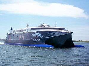
In 1998 Bay Ferries introduced the first high speed catamaran passenger-vehicle ferry service in North America when it purchased HSC Incat 046 from Incat in an aggressive bid to expand the Yarmouth - Bar Harbor ferry service. Throughout the 1990s the market for ferry services in southwestern Nova Scotia were threatened by significant expansions of 4-lane expressways in northern Nova Scotia and across southern New Brunswick so it was theorized that the Yarmouth - Bar Harbor ferry service could maintain market share if the ferry voyage time was shortened. Marketed as "The Cat", the use of the ferry service grew largely due to Bay Ferries' investment and the novelty of riding the ultra-modern high speed catamaran. In 2002 Bay Ferries traded in HSC Incat 046 for a larger vessel HSC The Cat which was also marketed as "The Cat". Beginning in 2003, Bay Ferries began operating HSC The Cat during the winter months on services in the Caribbean.
Following the end of the service offered by Scotia Prince Cruises in 2004, Bay Ferries began operating HSC The Cat in 2006 between Yarmouth to Portland, in addition to Bar Harbor; the old Portland ferry terminal being replaced by the newly built Ocean Gateway International Marine Passenger Terminal. Following a decline in American tourism to Nova Scotia, as well as record-high fuel prices, Bay Ferries sought subsidies from the federal and provincial governments for its Gulf of Maine ferry service. The federal government refused to provide a subsidy, having removed itself from operating such a service in 1997. However, the provincial government offered a subsidy to cover the operating loss and this was subsequently provided in 2007, 2008 and 2009. In 2009 the provincial government canceled the subsidy and Bay Ferries announced in December 2009 that it was ending its ferry service and sold the vessel.[15]
Nova Star Cruises
In 2013 the provincial government posted a request for proposals for re-establishing a Yarmouth - Maine ferry service, stating that a successful proponent would receive a $21 million subsidy over a 7-year period. In September 2013 it was announced that Nova Star Cruises was the successful proponent and in November 2013 it was confirmed that the service would start May 1, 2014 with the MV Nova Star offering daily round trips between Yarmouth and Portland. Nova Star Cruises has also announced it is examining the possibility of using the vessel during the winter months on a service between Colombia and Panama bypassing the Darién Gap. Nova Star's contract to provide ferry services between Yarmouth and Portland was not renewed for 2016.[16]
Return of The Cat

On March 24, 2016, Bay Ferries Limited announced that it had reached an agreement with the U.S. Maritime Administration and the U.S. Navy for a multi-year charter of the USNS Puerto Rico (HST-2). The vessel will be operated for a passenger/vehicle ferry service in the Gulf of Maine between Portland, Maine and Yarmouth. The vessel will continue to be named USNS Puerto Rico (HST-2) but the service and vessel will be branded as The CAT to align with the previous branding used by Bay Ferries. The vessel underwent a refit at a shipyard in South Carolina and the service began on June 15, 2016.[17][18][19]
Second World War
During the first year of the Second World War, Yarmouth was selected as the location for a British Commonwealth Air Training Plan (BCATP) facility. RCAF Station Yarmouth was originally opened in 1940 as three separate training sites (the East Camp, the West Camp and the Air Base).
The East Camp was home to a detachment of the Royal Air Force's No. 34 Operational Training Unit (from RCAF Station Pennfield Ridge), who trained bomber crews, as well as the Royal Navy's No. 1 Naval Air Gunners School who were located at Yarmouth from 1 January 1943 to 30 March 1945.
The West Camp was home to an RCAF Anti-Submarine Bomber Reconnaissance Squadron and several Eastern Air Command Bomber Reconnaissance Squadrons, such as 162 Squadron.
The Air Base was home to the 9th Light Anti-Aircraft Artillery, various RCAF and RAF Bomber Squadrons and an Army Co-operation Reconnaissance Flight. Its primary function was as an administrative and logistical support base to the RAF and RCAF squadrons in the area, in addition to providing a Weather Information Section, an Armament Section and a firing range.
A Hudson bomber from Royal Canadian Air Force Bomber Reconnaissance Squadron 113 in Yarmouth became the first aircraft of RCAF's Eastern Air Command to destroy a submarine, sinking U-754 about 100 mi (160 km) south of Yarmouth on July 31, 1942. The sinking resulted in 43 casualties and no survivors.[20]
Several smaller installations associated with RCAF Station Yarmouth were located in southwestern Nova Scotia, including a bombing range at Port Maitland, a fuel depot at Digby, and radar detachments at Plymouth, Tusket, Bear Point, Port Mouton and Rockville. In 1944, a detachment of the US Navy briefly came to Yarmouth to test the effectiveness of a blimp service. After a crash, the RCAF decided against this venture.
RCAF Station Yarmouth closed in 1945. The airfield was sold to the Department of Transport in 1946 and became the Yarmouth Airport. A Canadian Army training camp (known as Camp 60) on Parade Street also provided basic and artillery training for 20,000 soldiers during the war.[21]

Culture
The Western Branch of the Art Gallery of Nova Scotia is located in Yarmouth. The town is also home to the Yarmouth County Museum & Archives which preserves the history of the town and surrounding county and operates the Killam Brothers building on the waterfront. The Firefighters Museum, part of the Nova Scotia Museum system and the privately run Sweeney Fisheries Museum are also located in Yarmouth.
The Izaak Walton Killam Memorial house, founded in 1963, serves as the town's public library. It is the largest branch of Western Counties Regional Library and houses the regional library's headquarters.
The Yarmouth Arts Regional Council was established in 1974, under the leadership of Lydia Davison, a local music teacher. Over the next five years, with the assistance of the Canada Council and many volunteers, the Yarmouth Arts Regional Centre (Th'YARC) was constructed on the site of a former garage on Parade Street. Th'YARC continues to operate to this day, with the 350-seat Lydia Davison Theatre, an art gallery and a print-making shop.

A popular but unsupported cultural belief in Yarmouth holds that the American composer Meredith Willson wrote his well-known song "It's Beginning to Look a Lot Like Christmas" while staying in Yarmouth's Grand Hotel.[22]
In August 2004, a record mako shark was caught off the coast of Yarmouth during the Yarmouth Shark Scramble. It weighed 1,082 lb (491 kg) and set a new Canadian record. It is considered one of the largest mako sharks ever caught.[23]
Buildings and structures
Yarmouth is known for some of the most exuberant examples of Victorian houses styles in the Maritimes, a legacy of the wealthy captains and shipowners of the town's seafaring Golden Age.[24] A heritage district preserves several blocks of these residences, including the Lovitt House and Eakin/Hatfield House. On the waterfront, two historic warehouses survive from the sailing era, the Killam Brothers and Parker-Eakin's buildings, each with an associated wharf, which are the focal points of summer waterfront events.
Yarmouth's Main Street is marked by several distinctive Victorian commercial buildings such as the turreted Yarmouth Block Building.[25] The largest building in the town is a 1970s hotel, the Rodd Grand Hotel. It is built on the site of the original Grand Hotel, a Second Empire hotel which was the town's landmark for many years.
A landmark for Yarmouth Harbour is the large Cape Forchu Lighthouse which is located a few kilometeres way at the headland of Cape Forchu, the peninsula that guards Yarmouth Harbour. The tall "apple core" style is a notable example of modernist style light tower.[26]
Climate
| Yarmouth | ||||||||||||||||||||||||||||||||||||||||||||||||||||||||||||
|---|---|---|---|---|---|---|---|---|---|---|---|---|---|---|---|---|---|---|---|---|---|---|---|---|---|---|---|---|---|---|---|---|---|---|---|---|---|---|---|---|---|---|---|---|---|---|---|---|---|---|---|---|---|---|---|---|---|---|---|---|
| Climate chart (explanation) | ||||||||||||||||||||||||||||||||||||||||||||||||||||||||||||
| ||||||||||||||||||||||||||||||||||||||||||||||||||||||||||||
| ||||||||||||||||||||||||||||||||||||||||||||||||||||||||||||
Yarmouth lies on a climatic transitional zone between an oceanic climate and a humid continental climate (Köppen climate classification Dfb/Cfb).[28] Winters are cool and rainy with a January average of −3.0 °C (26.6 °F) though owing to strong maritime influences, temperatures below −20 °C (−4.0 °F) are very rare, and the average high never drops to below freezing at any point in the year.[27][29] During this period of time, the weather can be unsettled and cloudy due to the Nor'easters coming up the coast from the southwest.[29] As a result, Yarmouth averages only 68–100 hours of sunshine from December to February or 25%–34% of possible sunshine.[27] The average annual snowfall is 207 centimetres (81 in), which can come from Nor'easters from the southwest with a maximum snow depth of 7 centimetres (3 in) in January, owing to its mild winters, among the mildest in Canada east of the Rockies.[29][30]
Yarmouth's summers are cool due the strong coastal influence from the sea which keeps summer temperatures cool, meaning temperatures above 30 °C (86.0 °F) are very rare.[29] The average temperature in the warmest month, August is 17.0 °C (62.6 °F). Spring and fall are transitional seasons in which falls are warmer than spring since the waters are at the warmest temperatures in fall and the coldest during early spring.[29] Precipitation is significant, averaging over 1,292 millimetres (51 in) a year, with July and August the driest months on average and November the wettest month on average. An outstanding feature is Yarmouth's late-fall to early-winter precipitation maximum, owing to the combination of intense storm activity from November to January and relatively more-stable summers, with thunderstorm activity here much less frequent than in the U.S. Northeast, Mid-Atlantic and points southward. Yarmouth averages 1898 hours of sunshine or 42% of possible sunshine with summer being the sunniest and winter being the cloudiest.[30] Yarmouth averages 191 days of fog each year.[31]
The highest temperature ever recorded in Yarmouth was 32.5 °C (90.5 °F) on 16 July 2013.[32] The coldest temperature ever recorded was −24.4 °C (−12 °F) on 14 February 1894.[33]
| Climate data for Yarmouth Airport, 1981−2010 normals, extremes 1870−present[lower-alpha 1] |
|---|
Demography
The town has long held the highest teen pregnancy rate in the province.[35][36][37] Many studies have been done using teenagers in the town to examine the phenomenon.[35][36][38]
| Historical population | ||
|---|---|---|
| Year | Pop. | ±% |
| 1762 | 100 | — |
| 1871 | 4,696 | +4596.0% |
| 1881 | 5,324 | +13.4% |
| 1891 | 6,089 | +14.4% |
| 1901 | 6,430 | +5.6% |
| 1911 | 6,600 | +2.6% |
| 1921 | 7,073 | +7.2% |
| 1931 | 7,055 | −0.3% |
| 1941 | 7,790 | +10.4% |
| 1951 | 8,106 | +4.1% |
| 1956 | 8,095 | −0.1% |
| 1961 | 8,636 | +6.7% |
| 1966 | 8,319 | −3.7% |
| 1971 | 8,519 | +2.4% |
| 1976 | 7,801 | −8.4% |
| 1981 | 7,475 | −4.2% |
| 1986 | 7,617 | +1.9% |
| 1991 | 7,781 | +2.2% |
| 1996 | 7,568 | −2.7% |
| 2001 | 7,561 | −0.1% |
| 2006 | 7,162 | −5.3% |
| 2011 | 6,761 | −5.6% |
| [39][40][41][42][43] [44][45][46][47] | ||
|
|
| Level of education | Population | Pct (%) |
|---|---|---|
| No certificate, diploma, or degree | 2,090 | 36.34% |
| High school certificate or equivalent | 1,215 | 21.13% |
| Apprenticeship or trades certificate or diploma | 630 | 10.96% |
| College, CEGEP or other non-university certificate or diploma | 1,060 | 18.43% |
| University certificate or diploma below the bachelor level | 220 | 3.83% |
| University certificate, diploma or degree | 540 | 9.39% |
|
|
See also
References
- 1 2 2011 Statistics Canada Community Profile: Yarmouth, Nova Scotia
- ↑ Town of Yarmouth website
- ↑ Yarmouth: Lands End - Bay of Fundy
- 1 2 3 Brown, Thomas J. Place-names of the Province of Nova Scotia. Halifax, Nova Scotia: Royal Print & Litho. p. 157.
- ↑ Acadian Population Acadian Population Acadienne 1750 - University of Maine
- ↑ The Montreal Gazette - Aug 20, 1936 (Page 10) Google Newspapers
- ↑ A History of the County of Yarmouth, Nova Scotia - John Roy Campbell (Page 32)
- ↑ Yarmouth: Lands End
- ↑ Ships and Marine History Yarmouth County Museum and Archives
- ↑ Marine History of Yarmouth Nova Scotia: 03 - Yarmouth at the Peak of its Shipping Industry VirtualMuseum.ca
- ↑ Mario Theriault, Great Maritime Inventions Goose Lane Publishing (2001) p. 58-59
- ↑ "Patch's Propeller", Scientific America, Vol. 4, No. 5 (October 10, 1848) p. 33, featured in The Archimedes Screw website retrieved 31 January 2010
- ↑ "John Patch", Famous, should-be Famous and Infamous Canadians retrieved 31 Dec 2010.
- ↑ Jay White, "Canada's Ocean Playground: The Tourism Industry in Nova Scotia, 1870-1970", Nova Scotia Archives and Records Management
- ↑ "Yarmouth ferry service ends.". CBC News. cbc.ca. December 18, 2009. Retrieved December 18, 2009.
- ↑ <http://novastarcruises.com/>
- ↑ "The Cat expected to start ferry service in Maine in mid-June - The Portland Press Herald / Maine Sunday Telegram". pressherald.com. 25 May 2016. Retrieved 10 July 2016.
- ↑ "US Navy to lease high-speed transport to Bay Ferries - Professional Mariner - Web Bulletin 2016". professionalmariner.com. Retrieved 10 July 2016.
- ↑ 13, Cbs. "High-speed ferry begins service in Portland". bangordailynews.com. Retrieved 10 July 2016.
- ↑ The Creation of a National Air Force W.A.B. Douglas, (University of Toronto Press, 1986) p. 520
- ↑ RCAF Yarmouth East camp/West Camp Hank Reed, (East Camp Veterans, Yarmouth, 1996)
- ↑ It's Beginning to Look a Lot Like Christmas: Was it written in Yarmouth?
- ↑ Mako Shark caught off Yarmouth
- ↑ Mark Myers & Margaret McBurney, Atlantic Hearths: Early Homes and families of Nova Scotia, University of Toronto Press (1994), p. 160
- ↑ Elizabeth Pacey and Alvin Comiter, Landmarks: Historic Buildings in Nova Scotia, Nimbus (1994) pp. 136-137
- ↑ "Cape Forchu Lighthouse", Nova Scotian Lighthouse Preservation Society website
- 1 2 3 "Yarmouth A". Canadian Climate Normals 1981–2010 (in English and French). Environment Canada. Retrieved 28 September 2015.
- ↑ Kottek, M.; J. Grieser; C. Beck; B. Rudolf; F. Rubel (2006). "World Map of the Köppen-Geiger climate classification updated" (PDF). Meteorol. Z. 15 (3): 259–263. doi:10.1127/0941-2948/2006/0130. Retrieved December 1, 2012.
- 1 2 3 4 5 "Nova Scotia's Climate" (PDF). Natural History of Nova Scotia, Volume 1. Nova Scotia Museum of Natural History. Retrieved December 1, 2012.
- 1 2 3 "Canadian Climate Normals 1981–2010". Environment Canada. Retrieved 26 June 2016.
- ↑ Yarmouth fog data
- 1 2 "Daily Data Report for July 2013". Environment Canada. 22 September 2015. Retrieved 26 June 2016.
- 1 2 "Daily Data Report for February 1894". Environment Canada. 22 September 2015. Retrieved 26 June 2016.
- ↑
- 1 2 "Town Grapples with High Teen Pregnancy Rate". The Epoch Times. Retrieved March 18, 2014.
- 1 2 "Project to examine teen pregnancy rate in Yarmouth". The Vanguard. Retrieved March 18, 2014.
- ↑ "Pregnant teens face housing crunch in Yarmouth". Canadian Broadcasting Corporation. Retrieved March 18, 2014.
- ↑ "Yarmouth teen pregnancy research study receives preliminary information". The Vanguard. Retrieved March 18, 2014.
- ↑ 1762 Census
- ↑ , Censuses 1871-1931
- ↑ , Censuses 1871-1941
- ↑ , Census 1941-1951
- ↑ Town of Yarmouth (January 10, 2008). Municipal Planning Strategy (Report). Town of Yarmouth. p. 7.
- ↑ , Census 1961
- ↑ 1971, 1976 data: Table 1, Population Growth, Southwestern Region Statistical Profile, Nova Scotia Department of Development, April 1987, p, 7
- ↑ , Censuses 1981-2001
- ↑ , Census 2006
- ↑
- ↑ 2006 Statistics Canada Census Ethnocultural Portrait of Canada: Town of Yarmouth, Nova Scotia
Notes
- ↑ Climate data was recorded in the town of Yarmouth from December 1870 to March 1941 and at Yarmouth Airport from February 1940 to present.[34]</ref>
Y
r Month
i Jan
f Feb
Mar
Apr
May
e Jun
Jul
Aug
Sep
l Oct
h Nov
n Dec
armouth, Nova Scotia.jpg
|image_blaYear
Yarmouth NS logo 2016.jpg
|pus
pin_map = Nova Record high °C (°F)
l_position = right
|pushpin_map_caption = L 14.0
(57.2) , Nova Scotia |pushpin_mapsize = 250 |c 12.8
(55) = CA-NS |subdivision_type = [[Count 18.9
(66) _name = {{CAN}} |subdivision_type1 22.8
(73) ubdivision_name1 = {{NS}} |subdivision_ty 24.9
(76.8) ]] |subdivision_name2 = [[Yarmouth County 28.3
(82.9) uth]] |subdivision_type3 = |subdivision_n 32.5
(90.5) ype = Electoral Districts&nb 30.3
(86.5) p; <br>[[List of Canadian federal elector 29.4
(84.9) l]] |seat = <br>[[West Nova] 25.0
(77) = [[List of Nova Scotia provincial el 19.3
(66.7) rovincial]] |parts = [[Yarmou 16.5
(61.7) toral district)|Yarmouth]] |government_footnotes = |government_type 32.5
(90.5) _title = [[Mayor]] | eader_name = P Average high °C (°F) = Deputy Mayor |leader_name1 0.8
(33.4) leader_title2 = Councillors |leader_n 1.1
(34) {{Collapsible list |framestyle=border:none; 4.0
(39.2) des borders and improves row spacing--> |tit 9.0
(48.2) |1=Jim MacLeod |2=Sandy Dennis |3=Cliff Hoo 13.9
(57) and |5=Don Berry }} |leader_title3 = 18.0
(64.4) = [[Zach Churchill]] [[Nova Scotia Li 20.9
(69.6) leader_title4 = MP |leader_name4 21.1
(70) raser (Canadian politician)|Colin Fraser]] [[L 18.2
(64.8) ada|(L)]] |established_title = Founded |e 13.3
(55.9) = June 9, 1761 |established_title2 = In 8.7
(47.7) ished_date2 = August 6, 1890 |established 3.8
(38.8) - Incorporated (city) --> |established_date3 = |area_magnitude 11.1
(52) = <!--Enter: Imperial, f Imperial (metric) is de Daily mean °C (°F) otes = <ref name="SC2011">[http://ww −3
(27) ca/census-recensement/2011/dp-pd/prof/details/ −2.7
(27.1) 1=CSD&Code1=1202006&Geo2=CD&Code2=1202&Data=Co 0.3
(32.5) mouth&SearchType=Begins&SearchPR=01&B1=All&Cus 5.1
(41.2) Statistics Canada Community Profile: Yarmouth, 9.7
(49.5) > |area_total_km2 = |area_land_km2 13.8
(56.8) area_water_km2 = |population_as_of 16.8
(62.2) |population_footnotes = <ref name=" 17.0
(62.6) on_note = |population_total 14.1
(57.4) |population_density_km2 = 640.3 |popul 9.4
(48.9) = Change <small>(2006-11)</small> 5.2
(41.4) 1 = {{loss}}5.6% |timezone 0.2
(32.4) ic Standard Time|AST]] |utc_offset = -4 |timezone_DST 7.2
(45) T = -3 |latd=43 |latm= 0 |lats=10 |latNS=N |long Average low °C (°F) =03 |longEW=W |coordinates_display = inline,ti −6.9
(19.6) notes = |elevation_min_m = 0 |elevat −6.5
(20.3) 43 |postal_code_type = [[Canadian postal −3.4
(25.9) )]] |postal_code = [[List of B post 1.2
(34.2) |B]]5A |area_code = [[Area code 9 5.5
(41.9) code 782|782]] |area_code_type = [[Nor 9.6
(49.3) ing Plan|Area code]] |blank_name = 12.7
(54.9) in Nova Scotia|Highways]] |blank_info 12.9
(55.2) e=NS|Hwy|101}}<br>{{jct|state=NS|Hwy|103}}<br> 10.0
(50) unk|1}}<br>{{jct|state=NS|Trunk|3}}<br>{{jct|s 5.6
(42.1) }<br>{{jct|state=NS|Route|334}} |blank1_name 1.6
(34.9) ngs |blank1_info =3,323 |blank2_na −3.5
(25.7) an Income* |blank2_info =$31,584 [[Canadian dollar|CDN]] |bl 3.2
(37.8) tional Topographic System|NTS] Map |blank3_info Record low °C (°F) _name = [[Geographical Names Board −21.7
(−7.1) e |blank4_info = CBPIB }} '''Yarmo −24.4
(−11.9) wn]] located on the [[Bay of Fundy]] in southw −18.3
(−0.9) ]], [[Canada]]. Yarmouth is the [[shire town] −10.8
(12.6) ty, Nova Scotia|Yarmouth County]] and is large −2.2
(28) tre in the region. Long connected to [[fishin −1.1
(30) oximity to [[Georges Bank]], the town is locat 5.0
(41) of the world's largest [[lobster fishing]] gro 0.0
(32) sult receives Canada's largest lobster landing −2.3
(27.9) ttp://www.townofyarmouth.ca/ Town of Yarmouth −3.9
(25) =History== Originally inhabited by the [[Mi'km −12.2
(10) ], the region was known as "Keespongwitk" mean −22.2
(−8) e to its geographic isolation being located at the southwestern tip of −24.4
(−11.9) <ref>[http://bayoffundy.com/ar icles/yarmouth-lands-end/ Average precipitation mm (inches) ef><ref name="Names"/> The region may have po 127.3
(5.012) y [[Leif Ericson]]. An object known as the [[Y 101.8
(4.008) was found at the nearby village of [[Overton, 115.5
(4.547) ] in 1812. It was interpreted by some to have 101.4
(3.992) n, while others feel the markings are natural 100.9
(3.972) nhanced over the years. The stone is preserved 94.8
(3.732) ounty Museum & Archives]]. ===European settle 88.4
(3.48) was visited in 1604 by [[Samuel de Champlain]] 84.3
(3.319) Fourchu", meaning "forked or cloven cape."<ref 94.9
(3.736) book |last=Brown |first=Thomas J. |date= |tit 112.5
(4.429) e Province of Nova Scotia |url= https://archiv 139.3
(5.484) mesofprov00browuoft |location=Halifax, Nova Sc 131.8
(5.189) Print & Litho.|page=157 |isbn=}}</ref> The first Europeans to make a s 1,292.9
(50.902) e French Acadians. They set up a small fishing settlemen Average rainfall mm (inches) id 17th century and by 1750 the population was 68.7
(2.705) p://umaine.edu/teachingcanada/files/2010/10/ac 63.4
(2.496) df Acadian Population] Acadian Population Acad 85.6
(3.37) sity of Maine</ref> During the [[Seven Years' 92.0
(3.622) Planters]] settled at what is now the town of 100.6
(3.961) e grantees were from [[Yarmouth, Massachusetts 94.8
(3.732) d that Yarmouth be named after their former ho 88.4
(3.48) ws.google.com/newspapers?nid=1946&dat=19360820 84.3
(3.319) d=EpkFAAAAIBAJ&pg=7049,2176603&hl=en The Montr 94.9
(3.736) , 1936 (Page 10)] Google Newspapers</ref> Yarm 112.4
(4.425) une 9, 1761 when a ship carrying three familie 130.5
(5.138) wich, Massachusetts]]. The ship carried the fa 93.9
(3.697) ders, Ebenezer Ellis, and Moses Perry.<ref>A History of the County of Y 1,109.5
(43.681) ampbell (Page 32)</ref> Follow ng the war, [[Acadians]] Average snowfall cm (inches) é, Nova Scotia|Grand-Pré]] district who [[Expu 68.5
(26.97) s|returned from exile]] in 1767 settled in the 45.8
(18.03) r the [[American Revolution]], substantial num 29.9
(11.77) ire Loyalist]]s arrived in 1785. ===Shipbuild 9.8
(3.86) outhmuseum2.JPG|thumb|left|House flags of Yarm 0.33
(0.13) nies and ship portraits at the [[Yarmouth Coun 0.0
(0) Through the 19th century the town was a major 0.0
(0) ] centre, at one point boasting more registere 0.0
(0) capita]] than any other port in the world.<re 0.0
(0) fundy.com/articles/yarmouth-lands-end/ Yarmout 0.07
(0.028) From 1874 to 1885, Yarmouth was the second lar 9.2
(3.62) try in Canada following [[Saint John, New Brun 43.7
(17.2) armouth's tonnage peaked at 453 vessels aggregating 166,623 tons, and i 207.3
(81.61) d largest registered tonnage i Canada.<ref>[http://yarm Average precipitation days (≥ 0.2 mm) nd Archives</ref><ref>[http://www.virtualmuseu 20.1 gc-cms/histoires_de_chez_nous-community_memori 16.0 v2.php?id=story_line&lg=English&fl=0&ex=000005 14.6 4571&pos=1 Marine History of Yarmouth Nova Sco 13.4 3 - Yarmouth at the Peak of its Shipping Indus 13.6 irtualMuseum.ca</ref> Yarmouth ships were fou 11.9 most major ports throughout the world at this 10.9 including ships noted for courageous crews suc 9.6 the ship [[Research (ship)|''Research'']] in 1 9.9 nd ships noted for great size such as the ship 11.7 ounty of Yarmouth]]'' in 1884, one of the larg 15.2 oden hull ships ever built in Canada. [[John P 19.3 , the son of a Yarmouth sea captain, developed and built one of the fir 166.1 w propeller]] in 1832 (4 years before [[John Ericsson]]' Average rainy days (≥ 0.2 mm) was unsuccessful in a [[patent]] application 8.4 at year, but he continued to improve his prope 7.4 and received an American patent in 1849<ref>Ma 9.2 heriault, ''Great Maritime Inventions'' Goose 12.2 ublishing (2001) p. 58-59</ref> which drew pra 13.6 American scientific circles.<ref>[http://www. 11.9 s.com/cgi-bin/viewer.cgi?type=writings&file=18 10.9 033 "Patch's Propeller", ''Scientific America' 9.6 l. 4, No. 5 (October 10, 1848) p. 33, feature 9.9 ''The Archimedes Screw'' website retrieved 31 11.7 y 2010]</ref> However, by 1849 there were mult 13.5 ompeting versions of the screw propeller. Patc 11.9 r received money or recognition and died a poor man at Yarmouth in 1861 130.1 w.famouscanadians.net/name/p/p tchjohn.php "John Patch", Average snowy days (≥ 0.2 cm) The town of Yarmouth was incorporated on Aug 14.9 1890.<ref name="Names"/> ===Railways=== [[Fi 11.3 mouth N.S 1910.jpg|thumb|left|Yarmouth's water 8.4 circa 1910 showing the railway and steamship 3.1 ctions which emerged in the late 19th century. 0.17 wooden shipbuilding declined in the late 19th 0.0 ury, Yarmouth's shipowners re-invested their c 0.0 l into factories, iron-hulled [[Steamboat|stea 0.0 ]]s, and railways. The town's first railway wa 0.0 locally owned [[Western Counties Railway]] wh 0.10 s built from Yarmouth to [[Digby, Nova Scotia| 3.1 ]] in the 1870s. It eventually was merged int 11.0 [[Dominion Atlantic Railway]] (DAR), with a network extending into the 52.0 po is Valley]] [[City of Halifax|Halifax]] a d [[Truro, Nova Scotia|Tr Mean monthly sunshine hours ian Pacific Railway]] (CPR). The [[Halifax an 76.0 hwestern Railway]] was built along the south s 103.5 nking Yarmouth with [[Shelburne, Nova Scotia|S 141.6 e]], [[Liverpool, Nova Scotia|Liverpool]], [[B 178.8 ter, Nova Scotia|Bridgewater]] and [[City of H 213.0 Halifax]] in the early 20th century; the H&SW 217.6 ntually merged into the [[Canadian National Ra 227.6 (CNR). While iron-hulled steamships had led 220.0 decline of Yarmouth's once-thriving wooden shi 186.8 ng industry, they also made the port a vital c 165.6 on between Nova Scotia's rail lines and steams 97.6 estined for [[Boston]] and [[New York City|New 70.3 ]. Rail services were abandoned to Yarmouth in stages, beginning in 19 1,898.3 an ending in 990 (CPR). ===Steamships and erries=== [[Tourism]] has Percent possible sunshine s when [[Loran Ellis Baker]] founded the Yarmo 26.3 eamship Company. Steamship and railway promoti 35.0 ed in Yarmouth created the first tourism marke 38.4 n Nova Scotia.<ref>Jay White, [http://www.gov. 44.4 nsarm/virtual/tourism/early.asp?Language=Engli 46.7 nada's Ocean Playground: The Tourism Industry 47.1 a Scotia, 1870-1970"], ''Nova Scotia Archives 48.6 cords Management''</ref> Baker's steamships op 50.8 between Yarmouth and Boston until 1900, when 49.6 mpany was purchased by the Dominion Atlantic R 48.4 . The DAR and [[Halifax and Southwestern Railw 33.5 ffered connections for passengers arriving in 25.3 th with steamship services operating to New York City and Boston. In 1 41.2 xa iners at Yarmouth's Merchant Marine Institution made seaSource: Environment Canada[30][32][33]<ref name='Yarmouth'>"Yarmouth". Environment Canada. 22 September 2015. Retrieved 26 June 2016.
External links
| Wikimedia Commons has media related to Yarmouth, Nova Scotia. |
| Wikivoyage has a travel guide for Yarmouth (Nova Scotia). |
- Town of Yarmouth - official website
- Town of Yarmouth on facebook
- Canadian Encyclopedia Yarmouth Lighthouse perched atop Cape Forchu, Nova Scotia
| Counties | |
|---|---|
| Economic Regions | |
| Regional municipalities | |
| Municipal districts | |
| Towns | |
| Incorporated villages | |
| Lists | |
| |