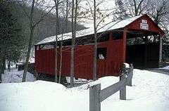
Y Covered Bridge No. 156
|
Y Covered Bridge No. 156 | |
 | |
  | |
| Location | Pennsylvania Route 757, southeast of Central, Sugarloaf Township, Pennsylvania |
|---|---|
| Coordinates | 41°17′23″N 76°21′52″W / 41.28972°N 76.36444°WCoordinates: 41°17′23″N 76°21′52″W / 41.28972°N 76.36444°W |
| Area | 0.1 acres (0.040 ha) |
| Built | 1887 |
| Built by | Larish, J.M. |
| Architectural style | Other, Queen Post |
| MPS | Covered Bridges of Columbia and Montour Counties TR |
| NRHP Reference # | 79003176[1] |
| Added to NRHP | November 29, 1979 |
The Y Covered Bridge No. 156 was a historic wooden covered bridge located in Sugarloaf Township in Columbia County, Pennsylvania. It was a 76-foot-long (23 m), Queen Post Truss bridge constructed in 1887. It crossed East Branch Fishing Creek. It was one of 28 historic covered bridges in Columbia and Montour Counties.[2]
It was listed on the National Register of Historic Places in 1979,[1] and destroyed in a suspicious fire on August 15, 1983.[3]
References
- 1 2 National Park Service (2010-07-09). "National Register Information System". National Register of Historic Places. National Park Service.
- ↑ "National Historic Landmarks & National Register of Historic Places in Pennsylvania" (Searchable database). CRGIS: Cultural Resources Geographic Information System. Note: This includes Bill Pennesi and Susan M. Zacher. "National Register of Historic Places Inventory Nomination Form: Y Covered Bridge No. 156" (PDF). Retrieved 2012-01-21.
- ↑ "Y , Columbia County". Covered Spans of Yesteryear - www.lostbridges.org. Retrieved December 11, 2012.
| Topics |   | |
|---|---|---|
| Lists by county |
| |
| Lists by city | ||
| Other lists | ||
| ||
This article is issued from Wikipedia - version of the 11/30/2016. The text is available under the Creative Commons Attribution/Share Alike but additional terms may apply for the media files.