Wolcott Mill Metropark
| Wolcott Mill Metropark | |
|---|---|
|
Wolcott Mill | |
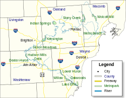 Location within metro Detroit | |
| Type | Regional park |
| Location | Lower Peninsula, Macomb County, Michigan USA |
| Coordinates | 42°46′32″N 82°56′32″W / 42.77552°N 82.94215°WCoordinates: 42°46′32″N 82°56′32″W / 42.77552°N 82.94215°W |
| Area | 2,625 acres (1,062 ha) |
| Operated by | Huron–Clinton Metroparks |
| Status | Open year round |
| Website | Official site |

Wolcott Mill Metropark is a Huron-Clinton Metropark located in rural Ray Township, Michigan. The northern branch of the Clinton River is a fixture of the park as it bisects the entirety of the park.
The Park
The park covers 2,625 acres (1,062 hectares) and features a variety of activities. Wolcott Mill has an 18-hole, 6,266-yard (5,730 m) golf course in the south as well as 10 miles (16 km) of equestrian trails. Wolcott Mill also has "Camp Rotary", a camping area for organized youth groups.
The Mill
The park's namesake mill was built in 1847 and operated until 1967. The mill was both a grist and a feed mill, and the machinery used for this purpose is still viewable. In addition, there are exhibits, demonstrations, and other buildings viewable in the Mill complex. The barn museum features the history of American barns, a buggy, antique farming equipment and tools. The various hiking trails of Wolcott Mill also start near the Mill complex.
The Farm
Wolcott Mill has a 250-acre (101 hectares) working farm. The farm has a herd of dairy cows as well as chickens, goats, pigs, sheep, and horses. There are also a variety of crops planted in the fields surrounding the farm.
External links
- Wolcott Mill Metropark - Huron-Clinton Metroparks
| Topics |  | |
|---|---|---|
| Detroit | ||
| Municipalities over 80,000 | ||
| Municipalities 40,000 to 80,000 | ||
| Cultural enclaves | ||
| Satellite cities | ||
| Counties in MSA | ||
| Counties in CSA | ||