St. Clair River
| Saint Clair River | |
|---|---|
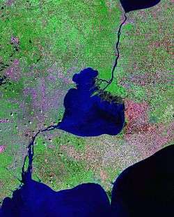 Landsat satellite photo, showing Lake Saint Clair (center), as well as St. Clair River connecting it to Lake Huron (to the North) and Detroit River connecting it to Lake Erie (to the South) | |
| Native name | Rivière Sainte Claire |
| Basin | |
| Main source | Lake Huron |
| River mouth | Lake St. Clair |
| Basin size | 223,600 sq mi (579,000 km2) |
| Physical characteristics | |
| Length | 40.5 mi (65.2 km) |
| Discharge |
|

The St. Clair River is a 40.5-mile-long (65.2 km)[1] river in central North America which drains Lake Huron into Lake St Clair, forming part of the international boundary between the Canadian province of Ontario and the U.S. state of Michigan. The river is a significant component in the Great Lakes Waterway, with shipping channels permitting cargo vessels to travel between the upper and lower Great Lakes.
Location
The river, which some consider a "strait,"[2] flows in a southerly direction, connecting the southern end of Lake Huron to the northern end of Lake St. Clair. It branches into several channels near its mouth at Lake St. Clair, creating a broad delta region known as the St. Clair Flats.
Size
The river is 40.5 miles (65.2 km) long[1] and drops 5 feet (2 m) in elevation from Lake Huron to Lake St. Clair. The flow rate averages around 182,000 cubic feet per second (5,200 m3/s), and the drainage area is 223,600 square miles (579,000 km2).[3] This takes into account the combined drainage areas of Lakes Huron, Michigan, and Superior.
History
In the 18th century, French voyageurs and coureurs des bois travelled on the river to trade with Native Americans and transport furs in canoes to major posts of French and British traders. European demand for American furs, especially beaver, was high until the 1830s.
Ships built at Marine City, Michigan, during the mid-19th century carried immigrants up the river on their way to new homes in the American West. Lumber harvested on The Thumb of Michigan was shipped downriver as log rafts to Detroit.
In the early 20th century, lake steamers carried passengers and traveled among the small towns along the St. Clair and Detroit rivers, and around the Great Lakes. During the 20th century, freighters traveled throughout the Great Lakes transporting commodities such as iron ore from the Mesabi Range, copper, and grain, all products of settlers' labor. Iron was taken to Ashtabula, Ohio and other industrial cities for processing and steel manufacture, and grain was often shipped through to major eastern markets such as Cleveland and New York City.
Watersheds
The St. Clair River and its Lambton County tributaries in Ontario contributes 103,210 acres (41,770 ha) to the watershed, although this does not include the Sydenham River watershed. In Michigan, the Black River, Pine River, and Belle River drain 780,600 acres (315,900 ha) in Lapeer, Macomb, Sanilac, and St. Clair counties; the watersheds around Bunce Creek and Marine City are relatively small.
Islands
- Stag Island lies between Corunna, Ontario and Marysville, Michigan.
- Fawn Island is near Port Lambton, Ontario and Marine City, Michigan.
- Walpole, Seaway, Bassett, Squirrel, Pottowatamie, St. Anne, Dickinson, Russell and Harsens islands are located where the St. Clair River flows into Lake St. Clair near Algonac, Michigan. These islands are part of the "St. Clair Flats", the only major river delta in the Great Lakes and the largest freshwater delta in North America. Six of the islands in this delta are unceded territory that are part of the Walpole Island First Nations, whose members include Ojibwe (Anishinaabe), Potowatomi, and Odawa peoples. They call this delta area Bkejwanong, meaning "where the waters divide."[4]
Land usage
Most of the watershed away from the river in Ontario and Michigan is used for agriculture. There were numerous sugar beet farms in the flatlands, and an annual beet market was held in Marine City, Michigan, for years at harvest time. Many of the 19th-century English immigrants to this area came from Lincolnshire, England, where sugar beets have been a major commodity crop.
A few forest and wetland areas have survived, although their area has declined significantly since European settlement, clearing and development of cultivated fields for various agricultural crops.
Much of the shoreline on both sides of the St. Clair River is urbanized and heavily industrialized. Intensive development has occurred in and near the adjacent cities of Port Huron, Michigan and Sarnia, Ontario, at the northern end of the river. The heaviest concentration of industry, including a large petrochemical complex, lies along the Ontario shore south of Sarnia.
Several communities along the St. Clair rely on the river as their primary source of drinking water. About one-third to one-half of the residents of Michigan receive their water from the St. Clair/Detroit River waterway. Industries including petroleum refineries, chemical manufacturers, paper mills, salt producers and electric power plants also need high-quality water for their operations. Since the late 20th century and passage of environmental laws to protect air and water quality, there have still been events when some of these industries have illegally contaminated river waters after discharging pollutants. Major clean-up activities were required.
Land habitat
Land areas of the St. Clair River shoreline and flats consist of two biological zones: upland and transitional, both of which are normally above the water table, but which may be flooded periodically.
The upland forests consist of deciduous species, many of which are near their northern climatic limit. Most pre-European settlement trees have been cleared for agriculture, industry, or urbanization. Remaining forest stands, such as oak savannas as well as lakeplain prairies, are found along the southern reaches of the river, particularly on the islands of the St. Clair River Delta and on the Michigan shore in Algonac State Park.
Transitional species are abundant in the low-lying regions, categorized as shrub ecotones, wet meadows, sedge marshes, and island shorelines and beaches. This habitat is home to water and land mammals, including humans, as well as songbirds, waterfowl, insects, pollinators, reptiles, and amphibians.
Water habitat
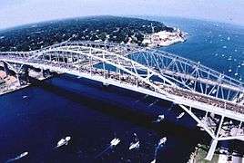
The aquatic habitat of the St. Clair River ranges from deep and fast near the Blue Water Bridge to shallow and slow in the lower river near its discharge point into Lake St. Clair.
Each area provides a unique habitat for aquatic life:
- macrophytes (visible marine plants),
- benthic macroinvertebrates (organisms that live at the bottom of a lake or stream),
- phytoplankton and zooplankton (floating plants and animals),
- emergent vegetation (plants seen above the water surface),
- fish (from minnows to large sport fish).
Area of concern
.jpg)
The St. Clair River is listed as an Area of Concern (AOC) because of pollutants such as bacteria, heavy metals, and toxic organics, which had come from municipal and industrial discharges, urban and rural runoff, combined sewer overflows (CSOs), and contaminated sediments.
The St. Clair River AOC includes the entire river, from the Blue Water Bridge at the north end, to the southern tip of Seaway Island, west to St. Johns Marsh and east to include the north shore of Mitchells Bay on Lake St. Clair. Anchor Bay is not included.
Through the Great Lakes Agreement, a Remedial Action Plan (RAP) was created to initiate cleanup measures. Its background report noted the adverse effects of pollution in the river and lakes:
- Restrictions on fish consumption
- Bird and animal deformities
- Degradation of benthos
- Restrictions on dredging activities
- Restrictions on drinking water consumption
- Beach closings
- Degradation of aesthetics
- Added cost to agriculture and industry
- Loss of fish and wildlife habitat
The RAP for the St. Clair River AOC was initiated in 1985. A bi-national group, called the RAP Team, was established in 1987 to develop the plan and ensure adequate and appropriate public involvement. The RAP Team included representatives from federal, state, and provincial governments of both Canada and the United States.
- A large blob of perchloroethylene was found at the bottom of the St Clair River due to runoff from Dow Chemical Corp in 1985. It remains there, slowly mixing with the water.[5]]
Erosion and Great Lakes drainage
Federal officials have long acknowledged that dredging and riverbed mining in the St. Clair dropped the long-term average of Great Lakes Huron and Michigan by about 16 inches. A bi-national Great Lakes water-level study concluded in 2013 that unexpected erosion since the last major St. Clair dredging project in the early 1960s has dropped the lakes' long-term average by an additional 3 to 5 inches. Today, these lakes are nearly 2 feet lower than before human modifications to the riverbed of the St. Clair River. This record low has raised concerns about the long-term health of the lakes. Activists urge remediation to slow the flow of waters through the St. Clair River and out of the lake system, to restore former water levels.[6]
Crossings
This is a list of bridges and other crossings of the St. Clair River from Lake St. Clair upstream to Lake Huron.
See also
References
- 1 2 U.S. Geological Survey. National Hydrography Dataset high-resolution flowline data. The National Map, accessed November 7, 2011
- ↑ Eckel, Patricia M. (May 4, 2005). "Some Thoughts on Isostatic Rebound as a Hypothetical Factor in Lake and Strait Characteristics in the Great Lakes". Niagara Issues. Missouri Botanical Garden. Retrieved April 9, 2015. line feed character in
|title=at position 60 (help) - ↑ "Great Lakes Factsheet No. 1". United States EPA. Retrieved 30 May 2013.
- ↑ "About nin.da.waab.jig", Walpole Island Heritage Centre, accessed 8 August 2014
- ↑ [http://www.sustreport.org/lakes/lakes_timeline.htm#seventies
- ↑ Dan Egan, "Lakes Michigan, Huron hit record low water level", Milwaukee Journal-Sentinel Online, 3 February 2013
External links
| Wikimedia Commons has media related to St. Clair River. |
Great Lakes of North America | ||
|---|---|---|
| Main lakes |  | |
| Secondary lakes | ||
| Bays and Waterways |
| |
| Islands | ||
| Historic geology | ||
| Government | ||
| Related topics |
| |
| Topics |  | |
|---|---|---|
| Detroit | ||
| Municipalities over 80,000 | ||
| Municipalities 40,000 to 80,000 | ||
| Cultural enclaves | ||
| Satellite cities | ||
| Counties in MSA | ||
| Counties in CSA | ||
Central/Mid-Michigan including the Tri-Cities and Thumb | |||||||||||
|---|---|---|---|---|---|---|---|---|---|---|---|
| Central cities | |||||||||||
| Counties |
| ||||||||||
| Geography | |||||||||||
| Transportation | |||||||||||
| Economy | |||||||||||
Coordinates: 42°31′59″N 82°40′29″W / 42.53306°N 82.67472°W