List of islands in the Detroit River
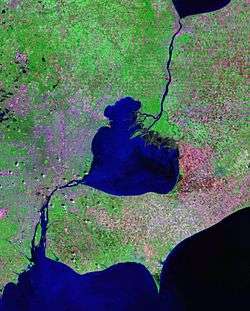
The following is a description of islands in the Detroit River. The Detroit River is a river in the Great Lakes system, about 32 miles (51 km) long and 0.5–2.5 miles (0.8–4.0 km) wide. The river serves as a major shipping channel, jointly controlled by the United States and Canada, and is a major component of the Canada–United States border. Ownership and control of the islands varies by their geographic location along the river. The majority of islands are on the American side of the river, which are all under the jurisdiction of Wayne County in Michigan. The Canadian islands are part of Essex County in Ontario. There are no islands in the Detroit River that are divided by the international border.
Most of the islands are very small and uninhabited, and many of these islands around the southern portion of the river serve as wildlife refuges as part of the Detroit River International Wildlife Refuge. The largest and most populous island is Grosse Ile at 9.0 sq mi (23.3 km²) and a population of around 10,000. Most of the islands in the Detroit River are around and closely connected to Grosse Ile. The Michigan city of Gibraltar is also located on several islands in the southern portion of the river. Some of the islands have also been geologically modified throughout the industrialization of the area. For example, Michigan's Stony Island and Canada's Crystal Island have been largely formed from dredged sediments for a deep shipping lane, and Zug Island and Elizabeth Park are artificial islands, as they were once part of the mainland.
 Michigan
Belle Isle

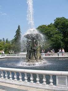
Belle Isle (42°20′35″N 82°58′28″W / 42.34306°N 82.97444°W) is a 1.53 sq mi (3.97 km²) island in the northern portion of the Detroit River about one mile (1.6 km) east of Downtown Detroit and one mile (1.6 km) west of Lake St. Clair. It is the northernmost island in the river — just barely extending further north than the easternmost island, Peche Island. The whole island is part of Belle Isle Park, except for two small secondary islands leased in 100-year increments in agreement respectively with the privately owned Detroit Yacht Club and to the Detroit Boat Club, the oldest rowing club in North America.. It is the largest urban island park in the United States and the third largest island in the river after Grosse Ile and Fighting Island. It is managed by the state of Michigan and is connected to the mainland by the MacArthur Bridge. The entire island itself is listed on the National Register of Historic Places as a historic district.[1][2][3]
Calf Island
Calf Island (42°06′11″N 83°10′45″W / 42.10306°N 83.17917°W) is a 7-acre (2.83 ha) island just west of Swan Island and Grosse Ile. The island is uninhabited, except for small number of herons. In 2002, Calf Island became part of the Detroit River International Wildlife Refuge.[1][4][5]
Celeron Island
Celeron Island (42°04′51″N 83°10′27″W / 42.08083°N 83.17417°W) is an 81-acre (33 ha) island located about 0.25 miles (0.4 km) east of Horse Island in the southern portion of the Detroit River near Lake Erie. While Celeron Island is closer to Gibraltar, Michigan, the island is administered by Grosse Ile Township to the north and is the southernmost of all islands in that township. Uninhabited, Celeron Island is technically four closely connected islands.[1][4]
Celeron Island was named for Pierre Joseph Céloron de Blainville.[6]
Edmond Island
Edmond Island (42°05′01″N 83°11′41″W / 42.08361°N 83.19472°W) is a 35-acre (14 ha) island within the city limits of Gibraltar, Michigan. It is one of the main islands of Gibraltar and is densely populated with one main circular road. There is one bridge to the island, and the island is only about 20 feet (6 m) from the mainland. Cherry Island of the Lake Erie Metropark is just south of Edmond Island, although by technical definition, Cherry Island is not an island since its connected to the mainland.[1]
Elba Island
Elba Island (42°06′09″N 83°08′51″W / 42.10250°N 83.14750°W) is a narrow 224 acre (91 ha) island just off the east coast of southern Grosse Ile. It is one of the four populated islands at the southern tip of Grosse Ile, and the few houses on this island are very affluent and expensive.[1][7]
Elizabeth Park
Elizabeth Park (42°07′56″N 83°10′49″W / 42.13222°N 83.18028°W) is a 162-acre (65 ha) park located on the shores of the Detroit River in Trenton, Michigan directly north of the Wayne County Bridge. Elizabeth Park was the first county park established in the state and was part of the former Monguagon Township. While the general area is referred to simply as Elizabeth Park, the island itself is sometimes referred to as "Slocum's Island" after the original owners, who donated the land to the county in 1919. Slocum's Island itself is much larger than the area belonging to Elizabeth Park, but that name has fallen into disuse. A small portion of the park is on the mainland, but most of it was cut off from the mainland by a small canal. The northern portion of the island belongs to Elizabeth Park, while the portion south of the Wayne County Bridge is occupied by the large Trenton Channel Power Plant. The Battle of Maguaga during the War of 1812 took place in the area.[8][9][10]
Fox Island
Fox Island (42°06′22″N 83°08′29″W / 42.10611°N 83.14139°W) is a very small 1.6 acre (6.5 ha) island about 1,000 feet (305 m) off the east coast of Elba Island near the southern tip of Grosse Ile. The island, which is a private island administered by Grosse Ile Township, is wooded and uninhabited.[1]
Grassy Island
Grassy Island (42°13′21″N 83°08′05″W / 42.22250°N 83.13472°W) is a 72-acre (29 ha) island located just north of Grosse Ile and west of Fighting Island. The closest city to the island is Wyandotte, Michigan. Originally, the island was much smaller, but it served as a disposal facility for millions of cubic yards of sediments that were dredged from the expanding of the River Rouge. Grassy Island is uninhabited and is part of the Detroit River International Wildlife Refuge. Grassy Island should not be confused with another island on the exact opposite side of the river named Grass Island, which part of Ontario.[1][4][11]
Grosse Ile
Grosse Ile (42°07′36″N 83°09′33″W / 42.12667°N 83.15917°W) /ˌɡroʊs ˈiːl/, colloquially referred to as the “Big Island” or the “Main Island” to distinguish it from the township as a whole, is by far the largest island in the Detroit River at approximately 9.0 sq mi (23.3 km²). While Grosse Ile Township consists of 12 individual islands, the largest of these island is commonly known simply as Grosse Ile. Grosse Ile itself is divided by the narrow Thorofare Channel, but the two segments are geologically the same island. The majority of islands in the Detroit River are within close proximity of Grosse Ile and are administered by the township. There are several small bridges connecting the populated islands on the southern tip, but only Grosse Ile connects to the mainland by the Wayne County Bridge in the middle of the island and the Grosse Ile Toll Bridge on the northern end. The Grosse Ile Municipal Airport is located on the southern end of the island. The township as a whole is one of the most affluent and safest in the state.[1][4][12]
Humbug Island
Humbug Island (42°06′32″N 83°11′06″W / 42.10889°N 83.18500°W) is an elongated 32 acre (13 ha) island located about 500 feet (152 m) from the mainland just northwest of Calf Island and west of Grosse Ile. The island, which is administered by the city of Trenton, is wooded and uninhabited. It is part of the much larger Humbug Marsh, which was incorporated into the Detroit River International Wildlife Refuge in 2004.[4][5]
Hickory Island
Hickory Island (42°05′18″N 83°09′18″W / 42.08833°N 83.15500°W) is a 132-acre (53 ha) island off the southern tip of Grosse Ile. Hickory Island is the southernmost of the inhabited islands of Grosse Ile Township, in which only the uninhabited Celeron Island is further south. Hickory Island can only be accessed by traveling through Meso Island, and both islands are part of a gated community. It is more densely populated than Meso Island, and the two are separated by a narrow 20 foot (6.1 m) boating channel.[1][7]
Horse Island
Horse Island (42°04′55″N 83°11′08″W / 42.08194°N 83.18556°W) is an elongated 38 acre (15 ha) island. It is the easternmost island of Gibraltar, Michigan, located about 1,200 feet (366 m) west of Celeron Island. Horse Island is connected to the rest of Gibraltar by a 50-foot (15 m) bridge. The island is densely populated and has one road ending in a cul-de-sac.[1]
Mamajuda Island
Mamajuda Island (42°11′32″N 83°08′10″W / 42.19222°N 83.13611°W) /mɑːməˈdʒuːdə/, sometimes identified as Mama Juda Island, is located just east of the northern tip of Grosse Ile (Hennepin Point) and about 500 feet (152 m) west of the Canada–United States border. The island is part of Grosse Ile Township.[13] It is the smallest of all charted islands in the Detroit River. The former 30 acre (12 ha) island has since been lost due to erosion. Only a very small portion of it, consisting of a few boulders, appears above water during times of low water levels. The island and its surrounding waters were incorporated into the Detroit River International Wildlife Refuge at its inception in 2001.[5][14]
Meso Island
Meso Island (42°05′35″N 83°09′06″W / 42.09306°N 83.15167°W), sometimes charted inaccurately as Meso Isle or Mesco Island, is a 121-acre (49 ha) island located about 200 feet (61 m) off the southeastern tip of Grosse Ile. It is one of the four inhabited islands off the southern coast of Grosse Ile and is the least populated of those islands. Meso Island is separated by a very narrow 20 foot (6.1 m) channel from Hickory Island to the south, and the two belong to the same very affluent gated community. Meso Island is also located about 1,000 feet (305 m) west of Sugar Island.[1][7]
Mud Island
Mud Island (42°14′19″N 83°08′24″W / 42.23861°N 83.14000°W) is a small, uninhabited 18.5 acre (7.5 ha) island about 250 feet (76 m) off the coast of Ecorse, Michigan and about 0.75 miles (1.21 km) west of the northern tip of Canada's Fighting Island. The island was donated to the Detroit River International Wildlife Refuge by the National Steel Corporation. Mud Island is currently the northernmost island in the refuge.[1][4][5]
Powder House Island
Powder House Island (42°06′26″N 83°08′08″W / 42.10722°N 83.13556°W), historically referred to as Dynamite Island, is the second-smallest named island in the Detroit River at approximately 0.2 acres (812 m²). The island is fairly remote and is about one-third mile (.53 km) east of the small Fox Island. Powder House Island is located almost in the center of the Detroit River but is far more visible to boats than Mamajuda Island. Like Fox Island, Powder House Island is uninhabited, privately owned, and administered by Grosse Ile Township.[1]
Round Island
Round Island (42°05′32″N 83°10′01″W / 42.09222°N 83.16694°W) is a 172-acre (70 ha) island off the southern coast of Grosse Ile. It is one of the five islands surrounding the southern coast of Grosse Ile, but it is the only of the five that is uninhabited. Round Island was once connected to Grosse Ile but is now separated by a 50-foot (15 m) channel used primarily for docked boats.[1][7][15]
Stony Island
Stony Island (42°07′41″N 83°07′51″W / 42.12806°N 83.13083°W) is an approximately 100 acre (40 ha) island located about 0.25 mi (0.4 km) east of the center of Grosse Ile. Stony Island's odd shape and stony composition came from the millions of cubic yards of sediment that were dredged out of the middle of the Detroit River to provide a deep shipping lane for large freighters. Stony Island is uninhabited and sparsely vegetated. Because the entire border separating Michigan and Ontario is water, this shipping lane is the narrowest width of water separating the two at any point along the international border. Stony Island is 500 feet (152 m) away from Ontario's Crystal Island.[1][4][16]
Sturgeons Bar
Sturgeons Bar (42°04′06″N 83°11′19″W / 42.06833°N 83.18861°W) is a very small, uninhabited 9.0 acre (36,400 m²) bar located about 300 feet (91.4 m) off the west coast of Rockwood at the southern end of the Detroit River on Lake Erie. Sturgeons Bar is off the coast of the Lake Erie Metropark and is technically the southernmost island in the Detroit River. The island is part of the Detroit River International Wildlife Refuge.[1][5]
Sugar Island
Sugar Island (42°05′29″N 83°08′39″W / 42.09139°N 83.14417°W) is a 30-acre (12 ha) island located about 800 feet (244 m) off the east coast of Meso Island. The island is administered by Grosse Ile Township but is uninhabited. In the early part of the 20th century, Sugar Island housed a resort park and had a ferry service to provide transportation to and from the island— most notably the ill-fated Tashmoo steamboat. The park was eventually torn down, and the island today is still privately owned but has no structures.[1][4][17]
Swan Island
Swan Island (42°05′57″N 83°10′26″W / 42.09917°N 83.17389°W) is a 58-acre (23 ha) island located off the southwestern tip of Grosse Ile. It is one of the four inhabited islands off the southern coast of Grosse Ile, and Swan Island is the smallest. Swan Island is separated from Grosse Ile by an artificial 75 foot (22.8 m) canal and is connected by one bridge.[1][7]
Zug Island
Zug Island (42°17′02″N 83°06′43″W / 42.28389°N 83.11194°W) is a 0.93 sq mi (2.4 km²) island located in the city of River Rouge, Michigan at the mouth of the River Rouge leading into the Detroit River. The island was created when the River Rouge was diverted from its natural course to provide a better shipping lane. Zug Island is heavily and densely industrialized, and public access is prohibited for security reasons. Because of its highly pollutant nature, Zug Island has a far-reaching environmental impact on the surrounding area. Zug Island has been chartered as the northernmost possible extension of the Detroit River International Wildlife Refuge, although it is not formally part of the current refuge.[1][5][18]
 Ontario
Bois Blanc Island
Bois Blanc Island (42°05′50″N 83°07′16″W / 42.09722°N 83.12111°W), popularly known as Boblo Island, is a 272-acre (110 ha) island and is the southernmost Canadian island in the Detroit River — directly across the river from the southern end of Grosse Ile. The island is administered by Amherstburg, Ontario. Bois Blanc Island was home to the Boblo Island Amusement Park from 1898 to 1993, and, today, the island is home to a small community. There are no bridges to the mainland, and transportation to and from the island is provided by private ferry.[4][19]
Crystal Island
Crystal Island (42°07′21″N 83°07′17″W / 42.12250°N 83.12139°W) is an uninhabited 92 acre (37 ha) island about 500 feet (152 m) directly across the international boundary from Michigan's Stony Island. Crystal Island is administered by Amherstburg. Like Stony Island, Crystal Island's odd shape came from the millions of cubic yards of sediment that were dredged out of the middle of the Detroit River to provide a deep shipping lane for large freighters. The island's odd shape created a pristine bay (known as Crystal Bay) that is unusually clear — hence the island's name — compared to the surrounding river waters due to the current keeping out pollution.[4][20]
Fighting Island
Fighting Island (42°13′18″N 83°07′12″W / 42.22167°N 83.12000°W) is the largest Canadian island in the Detroit River at 2.34 sq mi (6.06 km²) and the second largest after Grosse Ile. Administered by La Salle, Ontario, Fighting Island is located off the northeast tip of Grosse Ile on the other side of the international boundary. The island is uninhabited, mostly barren, and is used as a refuge by a number of different species. Fighting Island was once used as an industrial dumping ground but since been cleaned up. Fighting Island is a prospective area that may be included into the Detroit River International Wildlife Refuge.[4][5][21]
Grass Island
Grass Island (42°13′17″N 83°06′30″W / 42.22139°N 83.10833°W) is an extremely elongated and narrow 47 acre (19 ha) island located between Fighting Island and mainland Ontario. It is uninhabited, and despite its name, it is quite wooded. Administered by La Salle, Grass Island is sometimes incorrectly named Grassy Island, which is an American island on the exact opposite side of the river. Grass Island's unusual shape is due to the fact that it is just the northern end of a much larger underwater shoal.[4]
Peche Island
Peche Island (42°20′45″N 82°55′31″W / 42.34583°N 82.92528°W) /ˈpiːʃ/ is an 86-acre (35 ha) island and is the easternmost of all islands in the Detroit River. The American owned Belle Isle is the northernmost island with Peche Island being the easternmost due to the river's sudden bend. It is one mile (1.61 km) east of Belle Isle. Peche Island is the first island in the river, as it sits at the beginning of the river on Lake St. Clair. The island is fairly large and uninhabited, but unlike Belle Isle, Peche Island is wooded and unused. The city of Windsor, which had jurisdiction over the island, has continually debated on what to do with the island.[22]
Turkey Island
Turkey Island (42°11′09″N 83°06′48″W / 42.18583°N 83.11333°W) is a 39-acre (16 ha) island just off the southeastern tip of Fighting Island and directly across from the northern tip of Grosse Ile. The island is densely wooded and uninhabited. The island is administered by La Salle and is a prospective inclusion in the Detroit River International Wildlife Refuge.[4][5]
See also
- Detroit International Riverfront
- Detroit River
- Detroit River International Wildlife Refuge
- Islands of the Great Lakes
- List of islands of Michigan
- List of islands of Ontario
References
- 1 2 3 4 5 6 7 8 9 10 11 12 13 14 15 16 17 18 19 Buttle and Tuttle Ltd (2000–2008). "Wayne County island place names". Retrieved June 10, 2009.
- ↑ City of Detroit ITS (2009). "City of Detroit: Belle Isle". Retrieved June 10, 2009.
- ↑ Erickson, Cheryl. "Friends of Belle Isle". Retrieved June 10, 2009.
- 1 2 3 4 5 6 7 8 9 10 11 12 13 Metropolitan Affairs Coalition (Oct 2001). "A Conservation Vision for the Lower Detroit River Ecosystem" (PDF). Retrieved June 9, 2009.
- 1 2 3 4 5 6 7 8 U.S. Environmental Protection Agency (2009). "Detroit River-Western Lake Erie Basin Indicator Project". Retrieved March 17, 2010.
- ↑ Gannett, Henry (1905). The Origin of Certain Place Names in the United States. Govt. Print. Off. p. 73.
- 1 2 3 4 5 Lat-Long.com (2009). "Grosse Ile (southern islands)". Retrieved June 9, 2009.
- ↑ Wayne County Parks (2009). "Elizabeth Park". Retrieved July 3, 2009.
- ↑ Buttle and Tuttle Ltd. (2000–2008). "Elizabeth Park". Retrieved July 3, 2009.
- ↑ Trenton Historical Society (2007). "City History- "History of Detroit and Wayne County"". Retrieved October 29, 2009.
- ↑ Millsap, Stephanie (10 Jul 2008). "Grassy Island Disposal Facility". Retrieved June 10, 2009.
- ↑ "Grosse Ile ranked safest". Michigan Daily. 6 Oct 1997. Archived from the original on August 24, 2007. Retrieved June 13, 2009.
- ↑ Buttle and Tuttle Ltd (2000–2008). "Wayne County islands place names: Mamajuda Island". Retrieved December 25, 2009.
- ↑ Biggs, Jerry (Oct 2000). "Mission to Mama". Retrieved December 25, 2009.
- ↑ Ford Yacht Club (2000). "The Ford Yacht Club (Round Island)". Archived from the original on May 13, 2008. Retrieved June 10, 2009.
- ↑ US Army Corp of Engineers (27 Jul 2006). "Detroit River: altering the channel around Stony Island". Retrieved June 10, 2009.
- ↑ Water Winter Wonderland (2001–2007). "Water Winter Wonderland (Sugar Island)". Retrieved June 10, 2009.
- ↑ Urban Mapping, Inc. (2009). "Zug Island, River Rouge city data". Retrieved June 10, 2009.
- ↑ "A Tribute to the Bob-Lo Midway". 2009. Retrieved June 10, 2009.
- ↑ Hebert, James (7 Nov 1999). "An Aerial Tour of the Detroit River: Crystal Bay". Retrieved June 10, 2009.
- ↑ Lam, Tina (7 June 2009). "Detroit River island goes from wasteland to sanctuary". Detroit Free Press. Detroit, Michigan. Archived from the original on June 10, 2009. Retrieved 10 June 2009.
- ↑ Newman, Bernie (28 Mar 2009). "Peche Island". Retrieved June 10, 2009.
Great Lakes of North America | ||
|---|---|---|
| Main lakes | 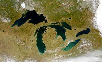 | |
| Secondary lakes | ||
| Bays and Waterways |
| |
| Islands | ||
| Historic geology | ||
| Government | ||
| Related topics |
| |