Wilroads Gardens, Kansas
| Wilroads Gardens, Kansas | |
|---|---|
| Census-designated place | |
 Wilroads Gardens  Wilroads Gardens | |
| Coordinates: 37°43′27″N 99°55′59″W / 37.72417°N 99.93306°WCoordinates: 37°43′27″N 99°55′59″W / 37.72417°N 99.93306°W[1] | |
| Country | United States |
| State | Kansas |
| County | Ford |
| Area[2] | |
| • Total | 2.253 sq mi (5.84 km2) |
| • Land | 2.253 sq mi (5.84 km2) |
| • Water | 0 sq mi (0 km2) |
| Elevation[1] | 2,441 ft (744 m) |
| Population (2010)[2] | |
| • Total | 609 |
| • Density | 270/sq mi (100/km2) |
| Time zone | CST (UTC-6) |
| • Summer (DST) | CDT (UTC-5) |
| Area code | 620 |
| FIPS code | 20-79625 [1] |
| GNIS feature ID | 473893 [1] |
Wilroads Gardens is an unincorporated community and census-designated place in Ford County, Kansas, United States.[1] Its population was 609 as of the 2010 census.[2]
See also
References
External links
Municipalities and communities of Ford County, Kansas, United States | ||
|---|---|---|
| Cities | 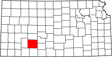 | |
| CDPs | ||
| Other unincorporated communities | ||
| Townships | ||
This article is issued from Wikipedia - version of the 7/31/2016. The text is available under the Creative Commons Attribution/Share Alike but additional terms may apply for the media files.