Spearville, Kansas
| Spearville, Kansas | |
|---|---|
| City | |
 Location within Ford County and Kansas | |
 KDOT map of Ford County (legend) | |
| Coordinates: 37°50′56″N 99°45′19″W / 37.84889°N 99.75528°WCoordinates: 37°50′56″N 99°45′19″W / 37.84889°N 99.75528°W | |
| Country | United States |
| State | Kansas |
| County | Ford |
| Area[1] | |
| • Total | 0.60 sq mi (1.55 km2) |
| • Land | 0.60 sq mi (1.55 km2) |
| • Water | 0 sq mi (0 km2) |
| Elevation | 2,461 ft (750 m) |
| Population (2010)[2] | |
| • Total | 773 |
| • Estimate (2015)[3] | 805 |
| • Density | 1,300/sq mi (500/km2) |
| Time zone | Central (CST) (UTC-6) |
| • Summer (DST) | CDT (UTC-5) |
| ZIP code | 67876 |
| Area code(s) | 620 |
| FIPS code | 20-67125 [4] |
| GNIS feature ID | 0473738 [5] |
| Website |
Spearville |
Spearville is a city in Ford County, Kansas, United States. As of the 2010 census, the city population was 773.[6]
History
19th century
The land for the townsite of Speareville was deeded by the Santa Fe to the Arkansas Valley Town Company in March, 1873, and was surveyed and platted. The town was named for Alden H. Speare, railroad director and president of the town company.[7] The city name appeared as both Spearville and Speareville in the early days.[7]
Spearville's first permanent residents were the Santa Fe section foreman, Jonas Stafford, and his family. Stafford was stationed at this particular watering spot beginning January, 1875. Stafford's wife and daughters opened an eating house, mainly for the accommodation of the section hands.[7]
The first post office in Spearville was established in June, 1877.[8]
Geography
Spearville is located at 37°50′56″N 99°45′19″W / 37.84889°N 99.75528°W (37.848750, -99.755318).[9] According to the United States Census Bureau, the city has a total area of 0.60 square miles (1.55 km2), all land.[1]
Climate
The climate in this area is characterized by hot, humid summers and generally mild to cool winters. According to the Köppen Climate Classification system, Spearville has a humid subtropical climate, abbreviated "Cfa" on climate maps.[10]
Demographics
| Historical population | |||
|---|---|---|---|
| Census | Pop. | %± | |
| 1880 | 156 | — | |
| 1900 | 157 | — | |
| 1910 | 576 | 266.9% | |
| 1920 | 629 | 9.2% | |
| 1930 | 703 | 11.8% | |
| 1940 | 603 | −14.2% | |
| 1950 | 610 | 1.2% | |
| 1960 | 602 | −1.3% | |
| 1970 | 738 | 22.6% | |
| 1980 | 693 | −6.1% | |
| 1990 | 716 | 3.3% | |
| 2000 | 813 | 13.5% | |
| 2010 | 773 | −4.9% | |
| Est. 2015 | 805 | [3] | 4.1% |
| U.S. Decennial Census | |||
2010 census
As of the census[2] of 2010, there were 773 people, 300 households, and 218 families residing in the city. The population density was 1,288.3 inhabitants per square mile (497.4/km2). There were 320 housing units at an average density of 533.3 per square mile (205.9/km2). The racial makeup of the city was 95.5% White, 0.4% African American, 0.6% Native American, 3.4% from other races, and 0.1% from two or more races. Hispanic or Latino of any race were 8.4% of the population.
There were 300 households of which 34.7% had children under the age of 18 living with them, 64.0% were married couples living together, 6.7% had a female householder with no husband present, 2.0% had a male householder with no wife present, and 27.3% were non-families. 26.3% of all households were made up of individuals and 15.7% had someone living alone who was 65 years of age or older. The average household size was 2.58 and the average family size was 3.08.
The median age in the city was 39.9 years. 28.1% of residents were under the age of 18; 6.6% were between the ages of 18 and 24; 21.7% were from 25 to 44; 28% were from 45 to 64; and 15.7% were 65 years of age or older. The gender makeup of the city was 49.3% male and 50.7% female.
2000 census
As of the census[4] of 2000, there were 813 people, 295 households, and 202 families residing in the city. The population density was 1,282.9 people per square mile (498.3/km²). There were 311 housing units at an average density of 490.7 per square mile (190.6/km²). The racial makeup of the city was 97.91% White, 0.25% African American, 0.37% Native American, 0.62% from other races, and 0.86% from two or more races. Hispanic or Latino of any race were 5.04% of the population.
There were 295 households out of which 38.0% had children under the age of 18 living with them, 62.7% were married couples living together, 3.4% had a female householder with no husband present, and 31.2% were non-families. 28.1% of all households were made up of individuals and 18.6% had someone living alone who was 65 years of age or older. The average household size was 2.69 and the average family size was 3.34.
In the city the population was spread out with 31.4% under the age of 18, 5.5% from 18 to 24, 25.8% from 25 to 44, 18.8% from 45 to 64, and 18.5% who were 65 years of age or older. The median age was 36 years. For every 100 females there were 94.5 males. For every 100 females age 18 and over, there were 93.1 males.
The median income for a household in the city was $40,625, and the median income for a family was $52,917. Males had a median income of $29,615 versus $21,875 for females. The per capita income for the city was $16,686. About 3.6% of families and 7.4% of the population were below the poverty line, including 9.2% of those under age 18 and 11.8% of those age 65 or over.
Transportation
Highways
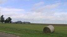
Spearville Wind Energy Facility
The Spearville Wind Energy Facility opened in 2006, with 67 GE Energy 1.5 MW wind turbines, for a total nameplate capacity of 100.5 MW.[11] It was the second largest wind farm in Kansas at the time it opened, behind the Gray County Wind Farm which opened in 2001. Phase I of the Smoky Hills Wind Farm edged Spearville into third place in 2008.

Notable people
- Willie Cauley-Stein, Professional basketball player
- Rick Dvorak, American football player
- Ignatius Strecker, served as Archbishop of Kansas City, Kansas from 1969 to 1993
Further reading
- The Story of the Marking of the Santa Fe Trail by the Daughters of the American Revolution in Kansas and the State of Kansas; Almira Cordry; Crane Co; 164 pages; 1915.[12]
References
- 1 2 "US Gazetteer files 2010". United States Census Bureau. Retrieved 2012-07-06.
- 1 2 "American FactFinder". United States Census Bureau. Retrieved 2012-07-06.
- 1 2 "Annual Estimates of the Resident Population for Incorporated Places: April 1, 2010 to July 1, 2015". Retrieved July 2, 2016.
- 1 2 "American FactFinder". United States Census Bureau. Retrieved 2008-01-31.
- ↑ "US Board on Geographic Names". United States Geological Survey. 2007-10-25. Retrieved 2008-01-31.
- ↑ "2010 City Population and Housing Occupancy Status". U.S. Census Bureau. Retrieved July 20, 2011.
- 1 2 3 http://spearville.org/history.html Spearville History
- ↑ "Kansas Post Offices, 1828-1961 (archived)". Kansas Historical Society. Archived from the original on October 9, 2013. Retrieved 10 June 2014.
- ↑ "US Gazetteer files: 2010, 2000, and 1990". United States Census Bureau. 2011-02-12. Retrieved 2011-04-23.
- ↑ Climate Summary for Spearville, Kansas
- ↑ "U.S. Wind Energy Projects - Kansas". American Wind Energy Association. 2008-11-19. Retrieved 2009-01-01.
- ↑ The Story of the Marking of the Santa Fe Trail by the Daughters of the American Revolution in Kansas and the State of Kansas; 1915
External links
| Wikimedia Commons has media related to Spearville, Kansas. |
- City
- Schools
- USD 381, local school district
- Maps
- Spearville City Map, KDOT
Municipalities and communities of Ford County, Kansas, United States | ||
|---|---|---|
| Cities | 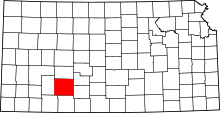 | |
| CDPs | ||
| Other unincorporated communities | ||
| Townships | ||