Williamstown, New Jersey
| Williamstown, New Jersey | |
|---|---|
| Census-designated place | |
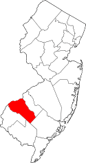
 Map of Williamstown highlighted within Gloucester County. Right: Location of Gloucester County in New Jersey. | |
| Coordinates: 39°41′03″N 74°58′08″W / 39.684113°N 74.968819°WCoordinates: 39°41′03″N 74°58′08″W / 39.684113°N 74.968819°W | |
| Country |
|
| State |
|
| County | Gloucester |
| Township | Monroe |
| Established |
1737 as Squankum 1842 as Williamstown |
| Area[1] | |
| • Total | 7.423 sq mi (19.225 km2) |
| • Land | 7.419 sq mi (19.216 km2) |
| • Water | 0.004 sq mi (0.010 km2) 0.05% |
| Elevation[2] | 141 ft (43 m) |
| Population (2010 Census)[3] | |
| • Total | 15,567 |
| • Density | 2,098.2/sq mi (810.1/km2) |
| Time zone | Eastern (EST) (UTC-5) |
| • Summer (DST) | Eastern (EDT) (UTC-4) |
| ZIP code | 08094[4] |
| Area code(s) | 856 |
| FIPS code | 3481380[1][5] |
| GNIS feature ID | 02390518[1][6] |
Williamstown is an unincorporated community and census-designated place (CDP) located within Monroe Township, in Gloucester County, New Jersey, United States.[7][8][9][10] As of the 2010 United States Census, the CDP's population was 15,567.[3]
History
Before settlement in 1737, Williamstown was inhabited by the Lenni-Lenape tribe of Native Americans, from whom the town derived its original name, "Squankum."[11] The name (Lenape for 'place where evil spirits dwell') was changed to Williamstown when the town's first post office was established, due to postal regulations that prohibited two towns from having the same name and there was an older Squankum located 60 miles northeast. It is generally thought that 'evil spirits' referred to the abundance of mosquitoes in the area, a by-product of the low-lying swamps that characterized the area during that time period. In the early eighteenth century, Richard Penn sold what eventually became Williamstown to his grandson, John Williams, who divided and resold the land in lots to settlers and for whom the town was eventually renamed.[12] The town was officially incorporated as Monroe Township in March 1859, with Williamstown as meeting place to vote and have town discussions. A municipal court was established in the Township of Monroe, in accordance with the provisions of Chapter 264 of the Laws of 1948.[13] The first school was built in 1750 and stood where the Washington Hotel now stands. The local schools operated on a pay-as-you-go basis until the 1850s and were predominantly church-run. The area built its first high school in 1958.
The population of the town remained small until the early 1830s when the glass industry sprung up (Glassboro, a neighboring town, still bears the name borne of that commercial boom). The first company to form was called Free Will Glass Manufacturing and caused a population surge. The industry thrived until the early 1900s when agricultural businesses began to flourish in the face of the waning glass industry. One notable company, The John Sharp Canning Co., still operates today as Blue Ribbon. The Monroe Township Historical Society was formed as a volunteer organization on October 16, 1974, by Mayor John W. Sharp (of the Canning Company Sharps), dedicated to the preservation of items that reflect the history of Monroe Township.
In 2014, the community had a death rate from heroin that was 25 times the national average, with about five people per year dying of overdoses and other complications in the previous decade.[14]
Geography
According to the United States Census Bureau, the CDP had a total area of 7.423 square miles (19.225 km2), including 7.419 square miles (19.216 km2) of land and 0.004 square miles (0.010 km2) of water (0.05%).[1][15]
Demographics
| Historical population | |||
|---|---|---|---|
| Census | Pop. | %± | |
| 1960 | 2,722 | — | |
| 1970 | 4,075 | 49.7% | |
| 1980 | 5,768 | 41.5% | |
| 1990 | 10,891 | 88.8% | |
| 2000 | 11,812 | 8.5% | |
| 2010 | 15,567 | 31.8% | |
| Population sources: 1960-1980[16] 1990-2010[9] 2000[17] 2010[3] | |||
2010 Census
The 2010 United States Census counted 15,567 people, 5,592 households, and 4,037 families residing in the CDP. The population density was 2,098.2 per square mile (810.1/km2). The CDP contained 5,857 housing units at an average density of 789.4 per square mile (304.8/km2). The racial makeup of the CDP was 80.43% (12,521) White, 13.08% (2,036) Black or African American, 0.19% (29) Native American, 2.04% (318) Asian, 0.01% (2) Pacific Islander, 1.79% (279) from other races, and 2.45% (382) from two or more races. Hispanics or Latinos of any race were 5.27% (820) of the population.[3]
Out of a total of 5,592 households, 35.5% had children under the age of 18 living with them, 54.3% were married couples living together, 13.1% had a female householder with no husband present, and 27.8% were non-families. 23.1% of all households were made up of individuals, and 11.0% had someone living alone who was 65 years of age or older. The average household size was 2.76 and the average family size was 3.26.[3]
In the CDP, 26.2% of the population were under the age of 18, 7.8% from 18 to 24, 26.4% from 25 to 44, 25.0% from 45 to 64, and 14.6% who were 65 years of age or older. The median age was 38.3 years. For every 100 females the census counted 90.8 males, but for 100 females at least 18 years old, it was 86.6 males.[3]
2000 Census
As of the 2000 United States Census[5] there were 11,812 people, 4,484 households, and 3,223 families residing in the CDP. The population density was 740.4/km2 (1,916.7/mi2). There were 4,764 housing units at an average density of 298.6/km2 (773.1/mi2). The racial makeup of the CDP was 85.68% White, 10.35% African American, 0.30% Native American, 0.96% Asian, 0.06% Pacific Islander, 0.99% from other races, and 1.67% from two or more races. Hispanic or Latino of any race were 2.87% of the population.[17]
There were 4,484 households out of which 32.6% had children under the age of 18 living with them, 55.6% were married couples living together, 12.2% had a female householder with no husband present, and 28.1% were non-families. 23.8% of all households were made up of individuals and 11.6% had someone living alone who was 65 years of age or older. The average household size was 2.63 and the average family size was 3.13.[17]
In the CDP the population was spread out with 25.2% under the age of 18, 8.0% from 18 to 24, 29.0% from 25 to 44, 23.0% from 45 to 64, and 14.9% who were 65 years of age or older. The median age was 37 years. For every 100 females there were 90.5 males. For every 100 females age 18 and over, there were 85.4 males.[17]
The median income for a household in the CDP was $44,200, and the median income for a family was $51,552. Males had a median income of $40,411 versus $29,112 for females. The per capita income for the CDP was $19,112. About 5.5% of families and 7.5% of the population were below the poverty line, including 10.8% of those under age 18 and 4.7% of those age 65 or over.[17]
Transportation
Cross Keys Airport is a public-use general aviation airport located 2.5 miles (4.0 km) northwest of the central business district.
Education
The Monroe Township Public Schools is a comprehensive public school district serving the educational needs of resident students from grades Kindergarten through twelve.
St. Mary School is a K-8 elementary school that operates under the auspices of the Roman Catholic Diocese of Camden.[18][19]
Recreation
Scotland Run Golf Club is a public golf course located in Williamstown, near U.S. Route 322.
Tall Pines Day Camp is a summer camp in Williamstown, for young children and teenagers. It was founded in 1996 and is accredited by the American Camping Association.[20]
Operating since 1961 and located within 5 minutes from the center of Williamstown, Hospitality Creek is a campground consisting of an RV park, olympic size swimming pool, 30 acre lake, and other outdoor amenities.[21]
Notable people
People who were born in, residents of, or otherwise closely associated with Williamstown include:
- Vince Kowalski (born 1992), offensive lineman who has played for the Green Bay Packers.[22]
References
- 1 2 3 4 Gazetteer of New Jersey Places, United States Census Bureau. Accessed July 21, 2016.
- ↑ U.S. Geological Survey Geographic Names Information System: Williamstown Census Designated Place, Geographic Names Information System. Accessed November 11, 2012.
- 1 2 3 4 5 6 DP-1 - Profile of General Population and Housing Characteristics: 2010 Demographic Profile Data for Williamstown CDP, New Jersey, United States Census Bureau. Accessed April 24, 2012.
- ↑ Look Up a ZIP Code for Williamstown, NJ, United States Postal Service. Accessed April 24, 2012.
- 1 2 American FactFinder, United States Census Bureau. Accessed September 4, 2014.
- ↑ US Board on Geographic Names, United States Geological Survey. Accessed September 4, 2014.
- ↑ GCT-PH1 - Population, Housing Units, Area, and Density: 2010 - County -- County Subdivision and Place from the 2010 Census Summary File 1 for Burlington County, New Jersey, United States Census Bureau. Accessed January 13, 2013.
- ↑ 2006-2010 American Community Survey Geography for New Jersey, United States Census Bureau. Accessed January 13, 2013.
- 1 2 New Jersey: 2010 - Population and Housing Unit Counts - 2010 Census of Population and Housing (CPH-2-32), United States Census Bureau, August 2012. Accessed January 13, 2013.
- ↑ Locality Search, State of New Jersey. Accessed April 19, 2015.
- ↑ "Monroe: It all started as Squankum". Courier Post. Retrieved November 18, 2012.
- ↑ "A History of Monroe Township" published by the Historic Society of Monroe Township.
- ↑ N.J.S.A.2B:12-1, New Jersey Office of Legislative Services.
- ↑ Polhamus, Andy. "Inside the N.J. town with a heroin death-rate 25 times the national average", NJ.com, January 28, 2016. Accessed July 23, 2016. "In Williamstown — where the heroin death rate in 2014 was nearly 25 times the national average — others haven't been so lucky.... Between 2004 and 2014, at least 53 people died of heroin or opiate overdoses in Williamstown, an unincorporated community located almost entirely in Monroe Township, Gloucester County.... It's not entirely clear why Williamstown — where the rate was 63.8 — has such a high concentration of overdose deaths, but some experts believe geography plays a major role."
- ↑ US Gazetteer files: 2010, 2000, and 1990, United States Census Bureau. Accessed September 4, 2014.
- ↑ Staff. 1980 Census of Population: Number of Inhabitants United States Summary, p. 1-141. United States Census Bureau, June 1983. Accessed January 12, 2012.
- 1 2 3 4 5 DP-1 - Profile of General Demographic Characteristics: 2000 from the Census 2000 Summary File 1 (SF 1) 100-Percent Data for Williamstown CDP, New Jersey, United States Census Bureau. Accessed November 11, 2012.
- ↑ About, St. Mary School. Accessed October 20, 2016.
- ↑ Catholic Schools Directory, Roman Catholic Diocese of Camden. Accessed October 20, 2016.
- ↑ Guide to ACA-Accredited Camps. p. 233. ISBN 0876031793. Retrieved November 19, 2012.
- ↑ Kiniry, Laura. Moon New Jersey, p. 201. Avalon Travel, 2009. ISBN 9781598801569. Accessed July 23, 2016.
- ↑ Fallon, Sean. "Football: Vince Kowalski signs as free agent with Green Bay", South Jersey Sports Digest, June 11, 2015. Accessed September 2, 2016. "After a spring of tryouts and free-agent mini-camps, Kowalski, a Williamstown High School and Villanova graduate, is getting a chance to live his childhood dream of playing in the National Football League."