Weston, Vermont
| Weston, Vermont | |
|---|---|
| Town | |
 Location in Windsor County and the state of Vermont. | |
 Weston, Vermont Location in the United States | |
| Coordinates: 43°18′N 72°47′W / 43.300°N 72.783°WCoordinates: 43°18′N 72°47′W / 43.300°N 72.783°W | |
| Country | United States |
| State | Vermont |
| County | Windsor |
| Chartered | 1799 |
| Area | |
| • Total | 35.2 sq mi (91.1 km2) |
| • Land | 35.0 sq mi (90.6 km2) |
| • Water | 0.2 sq mi (0.5 km2) |
| Elevation | 1,581 ft (482 m) |
| Population (2010) | |
| • Total | 566 |
| • Density | 16/sq mi (6.2/km2) |
| Time zone | Eastern (EST) (UTC-5) |
| • Summer (DST) | EDT (UTC-4) |
| ZIP code | 05161 |
| Area code(s) | 802 |
| FIPS code | 50-82000[1] |
| GNIS feature ID | 1462255[2] |
| Website |
www |
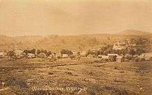
Weston is a town in Windsor County, Vermont, United States. The population was 566 at the 2010 census.[3] Home to the Weston Playhouse Theatre Company, it includes the villages of Weston and the Island.
History
Weston was originally the western part of Andover called West Town. Because Markham and Terrible mountains blocked travel between the town's halves, it was set off and incorporated on October 26, 1799, by the legislature. Set among the Green Mountains, the terrain is very rough and mountainous, but the intervales provided good soil for agriculture and pasturage. A second village grew at the canal cut to divert the West River to power watermills. Called the Island, it developed into a small mill town.[4]
By 1859, when Weston's population was 950, industries included ten sawmills, a gristmill, two tanneries, one wood-turning mill, one machine shop, one axe shop, one carding machine, in addition to shops for blacksmiths, carpenters, tinsmiths, wheelwrights and shoemakers.[5] Vermont's oldest professional theatre, the Weston Playhouse Theatre Company, was founded in 1935. The Vermont Country Store, a catalogue, retail, and e-commerce business, was established here in 1946 by Vrest and Ellen Orton.[6]
Geography
According to the United States Census Bureau, the town has a total area of 35.2 square miles (91.1 km2), of which 35.0 square miles (90.6 km2) is land and 0.19 square miles (0.5 km2), or 0.57%, is water.[7] The West River flows through the town.[8]
Weston is crossed by Vermont Route 100.
Demographics
| Historical population | |||
|---|---|---|---|
| Census | Pop. | %± | |
| 1810 | 629 | — | |
| 1820 | 890 | 41.5% | |
| 1830 | 972 | 9.2% | |
| 1840 | 1,032 | 6.2% | |
| 1850 | 1,851 | 79.4% | |
| 1860 | 932 | −49.6% | |
| 1870 | 931 | −0.1% | |
| 1880 | 987 | 6.0% | |
| 1890 | 864 | −12.5% | |
| 1900 | 756 | −12.5% | |
| 1910 | 632 | −16.4% | |
| 1920 | 436 | −31.0% | |
| 1930 | 411 | −5.7% | |
| 1940 | 457 | 11.2% | |
| 1950 | 468 | 2.4% | |
| 1960 | 442 | −5.6% | |
| 1970 | 507 | 14.7% | |
| 1980 | 627 | 23.7% | |
| 1990 | 488 | −22.2% | |
| 2000 | 630 | 29.1% | |
| 2010 | 566 | −10.2% | |
| Est. 2014 | 561 | [9] | −0.9% |
| U.S. Decennial Census[10] | |||
As of the census[1] of 2000, there were 630 people, 283 households, and 174 families residing in the town. The population density was 18.0 people per square mile (6.9/km2). There were 537 housing units at an average density of 15.3 per square mile (5.9/km2). The racial makeup of the town was 96.98% White, 0.32% African American, 0.95% Native American, 0.63% Asian, and 1.11% from two or more races. Hispanic or Latino of any race were 1.75% of the population.
There were 283 households out of which 21.6% had children under the age of 18 living with them, 52.3% were married couples living together, 6.0% had a female householder with no husband present, and 38.5% were non-families. 32.5% of all households were made up of individuals and 11.7% had someone living alone who was 65 years of age or older. The average household size was 2.16 and the average family size was 2.71.
In the town the population was spread out with 18.6% under the age of 18, 3.0% from 18 to 24, 19.0% from 25 to 44, 36.8% from 45 to 64, and 22.5% who were 65 years of age or older. The median age was 50 years. For every 100 females there were 110.7 males. For every 100 females age 18 and over, there were 104.4 males.
The median income for a household in the town was $44,792, and the median income for a family was $57,500. Males had a median income of $38,250 versus $24,167 for females. The per capita income for the town was $36,546. About 2.5% of families and 8.1% of the population were below the poverty line, including 5.4% of those under age 18 and 8.4% of those age 65 or over.
Sites of interest
- Vermont Country Store
- Weston Historical Society & Museum
- Weston Playhouse Theatre Company
- Weston Priory
- Kinhaven Music School
Notable people
- Aaron H. Cragin, US congressman and senator
- Joseph A. Gilmore, railroad superintendent and 29th Governor of New Hampshire
- Sam Lloyd, television actor
- Mildred Ellen Orton, founder of the Vermont Country Store
- Hiram Sanford Stevens, US congressman
- Syd Straw, Singer & Actor / Residence[11]
References
- 1 2 "American FactFinder". United States Census Bureau. Retrieved 2008-01-31.
- ↑ "US Board on Geographic Names". United States Geological Survey. 2007-10-25. Retrieved 2008-01-31.
- ↑ "Profile of General Population and Housing Characteristics: 2010 Demographic Profile Data (DP-1): Weston town, Windsor County, Vermont". U.S. Census Bureau, American Factfinder. Retrieved August 1, 2012.
- ↑ Hayward's New England Gazetteer of 1839
- ↑ Austin J. Coolidge & John B. Mansfield, A History and Description of New England; Boston, Massachusetts 1859
- ↑ Virtual Vermont -- Weston, Vermont
- ↑ "Geographic Identifiers: 2010 Demographic Profile Data (DP-1): Weston town, Windsor County, Vermont". U.S. Census Bureau, American Factfinder. Retrieved August 1, 2012.
- ↑ DeLorme (1996). Vermont Atlas & Gazetteer. Yarmouth, Maine: DeLorme. ISBN 0-89933-016-9
- ↑ "Annual Estimates of the Resident Population for Incorporated Places: April 1, 2010 to July 1, 2014". Retrieved June 4, 2015.
- ↑ "U.S. Decennial Census". United States Census Bureau. Retrieved May 16, 2015.
- ↑ Facebook/Syd Straw page
External links
- Town of Weston official website
- Wilder Memorial Library
- Weston Town Info & Photos from Vermont Living Magazine
Municipalities and communities of Windsor County, Vermont, United States | ||
|---|---|---|
| Towns | 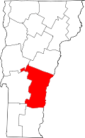 | |
| Villages | ||
| CDPs | ||
| Other communities | ||