Western Highway (Victoria)
| Western Highway Victoria | |
|---|---|
 | |
| General information | |
| Type | Highway |
| Length | 314 km (195 mi) |
| Route number(s) |
|
| Former route number |
|
| Major junctions | |
| West end |
|
| |
| East end |
|
| Location(s) | |
| Major settlements | Nhill, Dimboola, Horsham, Stawell, Ararat, Beaufort |
| Highway system | |
|
Highways in Australia National Highway • Freeways in Australia Highways in Victoria | |
| |
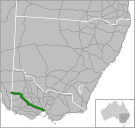
The Western Highway is part of the principal route linking the Australian cities of Melbourne and Adelaide with a length of approximately 314 kilometres. It is a part of the National Highway network and designated as National Highway A8. The eastern end continues on as the Western Freeway at Beaufort, and the western end continues beyond the Victorian border as Dukes Highway, the other sections of the Melbourne–Adelaide National Highway.
The Western Highway is the second busiest national highway in Australia, in terms of freight movements, with over five million tonnes annually. It provides the critical link between the eastern seaboard and South Australia and Western Australia. The towns along the way, including Ballarat, Ararat, Stawell and Horsham, are major agricultural and manufacturing centres.
Route

The Western Highway begins at the Victorian–South Australian border, east of Bordertown. It is mainly a high quality single carriageway from there to just outside the Melbourne side of Beaufort, Victoria, with adequate numbers of overtaking lanes. However, the highway does pass through several agricultural centres, for example Horsham, Victoria, slowing down traffic significantly.
Just east of Beaufort, the Western Highway becomes the Western Freeway, adopting freeway standards with two lanes running each way, and begins bypassing most of the towns the old alignment of the highway used to serve.
The newest section of freeway standard dual carriageway (25 km in length) opened on 6 March 2015. This runs between the end of the Ballarat bypass between a new flyover/interchange with the C805 (Avenue of Remembrance, Burrumbeet) to just outside Beaufort (including a bypass of Trawalla) providing 156 km of freeway standard road between Melbourne and Beaufort.
Plans are underway for the end of this freeway to be extended from the current terminus just outside Beaufort westward towards Ararat and eventually to Stawell. Part of the Beaufort to Ararat section is now under construction
Upgrades
In 2001 work started on a 4.2 kilometre long deviation at Armstrong, involving 200,000 cubic metres of earthworks and a new bridge over the main Melbourne–Adelaide railway. Previously high vehicles could not travel under the rail overpass and were forced to detour around it, in addition the poor road conditions led to a number of accidents and fatalities.[1] Costing $6.1 million the work was completed by 2003.[2]
Proposed duplication of the Western Highway between Ballarat and Stawell between 2009 and 2014, to be funded by Auslink 2.[3]
The clearing of wide swathes of the ancient red gums by Vic Roads near Beaufort has resulted in community angst and public meetings are being held. Near Buangor, 74 km west of Ballarat, two women chained themselves to a red gum on 16 March for 4 ½ hours to draw attention to the issue. Mrs Isabel Mackenzie, a long-term resident of the area, said she was concerned at the environmental impact of trees that are hundreds of years old. Helen Lewers, said that VicRoads should reroute the highway between Buangor and Stawell to preserve the native roadside vegetation.[4]
Major intersections
| LGA | Location[5] | km[5] | mi | Destinations | Notes |
|---|---|---|---|---|---|
| South Australia – Victoria state border | 439 | 273 | South Australia – Victoria state border | Continues in South Australia as the Dukes Highway | |
| West Wimmera | Kaniva | 414 | 257 | Melbourne–Adelaide railway | |
| 412 | 256 | ||||
| Hindmarsh | Nhill | 376 | 234 | ||
| 374 | 232 | ||||
| 373 | 232 | ||||
| 372 | 231 | ||||
| Dimboola | 342 | 213 | Wimmera River | ||
| 338 | 210 | C227 is the road through Dimboola, highway uses bypass | |||
| 338 | 210 | Melbourne–Adelaide railway | |||
| 335 | 208 | ||||
| 334 | 208 | C227 is the road through Dimboola, highway uses bypass | |||
| Horsham | Wail | 326 | 203 | Melbourne–Adelaide railway | |
| Horsham | 300 | 190 | |||
| Duplex with B200 for 3km and B240 for 400m | |||||
| 299 | 186 | ||||
| 298 | 185 | Wimmera River | |||
| 297 | 185 | ||||
| Bungalally | 286 | 178 | |||
| Drung | 283 | 176 | |||
| Northern Grampians | Deep Lead | 246 | 153 | ||
| Stawell | 235 | 146 | |||
| 234 | 145 | ||||
| 231 | 144 | ||||
| Ararat | Ararat | 205 | 127 | ||
| 203 | 126 | ||||
| Buangor | 188 | 117 | Melbourne–Adelaide railway | ||
| Pyrenees | Beaufort | 163 | 101 | Melbourne–Adelaide railway | |
| 161 | 100 | ||||
| Ballarat | Burrumbeet | 134 | 83 | ||
| Windermere | 133 | 83 | Melbourne–Adelaide railway | ||
| Miners Rest | 124 | 77 | Continues as Western Freeway | ||
| 1.000 mi = 1.609 km; 1.000 km = 0.621 mi | |||||
See also
References
- ↑ "Works to start on Armstrong deviation". Stawell Times News. www.stawelltimes.com.au. 2 November 2001. Retrieved 21 June 2010.
- ↑ John Anderson (14 May 2002). "Federal Government Keeps Victoria Moving". Budget Media Releases 2002–03. www.infrastructure.gov.au. Retrieved 21 June 2010.
- ↑ "Western Highway Duplication – Ballarat to Stawell" (pdf). Department of Transport, State Government of Victoria, Australia. p. 58. Retrieved 6 January 2014.
- ↑ Hatch, Patrick (16 March 2015). "Grandmother, 91 chains herself to tree in Victoria's west to protest roadwork". The Age.
- 1 2 Google (23 November 2016). "Western Highway: Border to Melbourne" (Map). Google Maps. Google. Retrieved 23 November 2016.