Ararat, Victoria
| Ararat Victoria | |
|---|---|
 Barkly Street, looking east towards Mt Langi Ghiran | |
 Ararat | |
| Coordinates | 37°17′0″S 142°55′0″E / 37.28333°S 142.91667°ECoordinates: 37°17′0″S 142°55′0″E / 37.28333°S 142.91667°E |
| Population | 7,024 (2011 census)[1] |
| • Density | 516.5/km2 (1,338/sq mi) |
| Established | 1857 |
| Postcode(s) | 3377 |
| Area | 13.6 km2 (5.3 sq mi) |
| Location | |
| LGA(s) | Rural City of Ararat |
| State electorate(s) | Ripon |
| Federal Division(s) | Wannon |
Ararat is a city in south-west Victoria, Australia, about 198 kilometres (120 mi) west of Melbourne, on the Western Highway on the eastern slopes of the Ararat Hills and Cemetery Creek valley between Victoria's Western District and the Wimmera. Its urban population according to the Council's Website is 8,076 and services the region of 11,752 residents across the Rural City's boundaries [2]
It is the largest settlement in the Rural City of Ararat local government area and is the administrative centre.
The discovery of gold in 1857 during the Victorian gold rush transformed it into a boomtown which continued to prosper until the turn of the 20th century after which it has steadily declined in population. It was proclaimed as a city on 24 May 1950. After a decline in population over the 1980s and 90s, there has been a small but steady increase in the population,[3] and it is the site of many existing and future, large infrastructure projects including the Hopkins Correctional Facility development project.[4]
It is named after Mount Ararat 10 kilometres south west of the town which was named by Horatio Wills in 1841.
History


Prior to the European settlement of Australia, Ararat was inhabited by the Tjapwurong Indigenous Australian people.[5]
Europeans first settled in the Grampians region in the 1840s after surveyor Thomas Mitchell passed through the area in 1836. In 1841, Horatio Wills, on his way to selecting country further south, wrote in his diary, "like the Ark we rested" and named a nearby hill Mt Ararat. It is from this entry and the nearby Mount that the town takes its name. The Post Office opened 1 February 1856 although known as Cathcart until 31 August 1857.[6]
In 1857, a party of Chinese miners en route to the Central Victorian gold fields struck gold at the Canton Lead which marked the beginning of great growth in Ararat. The Chinese community was substantial in Ararat, and the Gum San Chinese Heritage Centre commemorates the history of the community.[7]
Rapid growth brought about a municipality, which was incorporated as a borough on 24 September 1858.
Ararat became a city of asylums, with a large facility Aradale Mental Hospital was opened in 1865 and J Ward, a lunatic asylum for criminally insane (formerly the Ararat County Gaol), opened in 1887. Both have been closed but remain as significant reminders of the city's role in the treatment of mentally ill patients.
Vines were planted in 1863 by Swiss settlers, the Pola family.
Economy
Ararat's economy is driven by primary industries of the region including wool, beef and the Grampians Wine Region. The region has a number of wind farms including the Challicum Hills Wind Farm produce large amounts of renewable energy to the National Electricity Market. It is also home to AF Gason Pty Ltd one of Australia's largest manufacturers of farm machinery.
The city also has a significant service economy with health, community services and is a regional commerce centre. HM Prison Ararat is located in the town.
Servicing visitors to the Grampians National Park and the local wine industry, tourism is a relatively small but significant industry in Ararat, employing 150 people and generating around $8 million to the economy, however its impact on the surrounding region is significant with tourists spending $270 million annually.[8] Key tourist attractions include the Ararat Regional Art Gallery, Mount Langi Ghiran winery, tours through Aradale (Australia's largest abandoned 1800's lunatic asylum) and the Gum San Chinese Heritage Centre.[9]
Geography

Ararat is nestled between several mountain ranges, including the Grampians National Park, Mount Langi Ghiran, Mount Cole, Mount Buangor, Ararat Hills Regional Park and the Pyrenees Ranges. Cemetery Creek, the valley's main catchment runs through the north of the town while Green Hill lake is on the city's eastern fringe.
Climate
| Climate data for Ararat, Victoria | |||||||||||||
|---|---|---|---|---|---|---|---|---|---|---|---|---|---|
| Month | Jan | Feb | Mar | Apr | May | Jun | Jul | Aug | Sep | Oct | Nov | Dec | Year |
| Record high °C (°F) | 43.1 (109.6) |
44.7 (112.5) |
39.0 (102.2) |
33.5 (92.3) |
26.2 (79.2) |
20.4 (68.7) |
21.0 (69.8) |
24.5 (76.1) |
28.9 (84) |
34.7 (94.5) |
39.8 (103.6) |
42.5 (108.5) |
44.7 (112.5) |
| Average high °C (°F) | 26.9 (80.4) |
27.1 (80.8) |
23.9 (75) |
19.5 (67.1) |
15.4 (59.7) |
12.4 (54.3) |
11.7 (53.1) |
13.0 (55.4) |
15.2 (59.4) |
18.1 (64.6) |
21.5 (70.7) |
24.5 (76.1) |
19.1 (66.4) |
| Average low °C (°F) | 11.2 (52.2) |
11.3 (52.3) |
9.6 (49.3) |
7.2 (45) |
5.5 (41.9) |
3.9 (39) |
3.4 (38.1) |
3.9 (39) |
5.1 (41.2) |
6.0 (42.8) |
7.8 (46) |
9.3 (48.7) |
7.0 (44.6) |
| Record low °C (°F) | 0.6 (33.1) |
0.3 (32.5) |
−0.9 (30.4) |
−5.7 (21.7) |
−5.2 (22.6) |
−6.4 (20.5) |
−7.3 (18.9) |
−6.2 (20.8) |
−4.0 (24.8) |
−4.5 (23.9) |
−4.5 (23.9) |
−1.0 (30.2) |
−7.3 (18.9) |
| Average precipitation mm (inches) | 39.9 (1.57) |
32.5 (1.28) |
30.6 (1.21) |
42.5 (1.67) |
51.6 (2.03) |
56.4 (2.22) |
62.8 (2.47) |
69.0 (2.72) |
59.7 (2.35) |
56.5 (2.22) |
45.0 (1.77) |
37.7 (1.48) |
584.2 (22.99) |
| Source: [10] | |||||||||||||
Demographics
88% of people in Ararat were born in Australia.[5]
62% of people in Ararat identify as Christian.[11] Anglican and Catholic faiths are evenly represented with 18% of people identifying with each.
Governance

The city is the location of the municipal offices and seat of government for the Rural City of Ararat local government area.[12] Ararat is represented by the federal Division of Wannon.
For law enforcement, Ararat has a single police station[13] as well as a magistrates court and a children's court all located on Barkly Street.[14][15]
Education
Ararat has four primary schools - Ararat 800 Primary; Ararat West Primary; Ararat North Primary and St Marys Catholic Primary School. In addition there are several kindergartens in the city. There are two main colleges – Ararat Community College and Marian College which is a Catholic high school. Ararat has regional campuses of the Federation University Australia (formerly the University of Ballarat)[16] and Melbourne Polytechnic (formerly the Northern Melbourne Institute of TAFE).[17]
Culture
Art
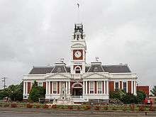
Ararat's National Trust listed[18] former town hall with its elaborate clock tower, designed by Molloy and Smith and built in 1899, is now home to the Ararat Regional Art Gallery,[19] and the Ararat Performing Arts Centre[20] for the city.
Sport
Australian rules football is a popular sport in Ararat. The Ararat Football Club (formed in 1871) was a founding club of the Wimmera Football League and continues to compete with its most recent premiership in 2001.[21] A second club, the Ararat Eagles Football Club was formed more recently in 2000 to play in the Lexton Plains Football League,[22] but now play in the Mininera & District Football League. Like many country football clubs, Ararat's clubs offer netball as a popular sport for women in Ararat, with the Ararat Rats representing the city in the Wimmera Netball Association.[23]
The horse racing club, the Wimmera Racing Club, schedules around five race meetings a year at Ararat including the Ararat Cup meeting in November.[24]
Ararat Harness Racing Club conducts regular meetings at its racetrack in the town.[25]
Golfers play at the Aradale Golf Club on Grano Street[26] or at the course of the Chalambar Golf Club on Golf Links Road.[27]
Motocross has become a popular sport in the area, and the Ararat Motorcycle Club regularly holds events up to state level.
Association Football is played at junior level, with the Ararat and Grampians YMCA school competition from years 8–12.
Festivals
The city's main community festival is known as the Golden Gateway Festival and has run since 1958 when it was set up to commemorate the city's centenary.[28]
The Jailhouse Rock Festival (since 1994 a retro 1950s themed festival) are two major festival events in Ararat.[29]
In popular culture
Two Royal Australian Navy ships have been named after this town. HMAS Ararat (K34), a Bathurst-class corvette, and HMAS Ararat (ACPB 89), an Armidale-class patrol boat.
In 2014 Ararat residents appeared in the Channel 10 hit show The Biggest Loser.[30]
Attractions
Popular tourist destinations include the Gum Sam Chinese Heritage Centre, Aradale Lunatic Asylum Tours,[31] Langi Morgala Museum, The Astor Cinema, and J Ward. Guests can attend a day time history tour of J Ward or be incarcerated for an evening on the J Ward Ghost Tour.
Infrastructure
Transport
The main form of transport is road transport and motor vehicles. According to the 2006 Census, 88% of people traveled to work by motor vehicle, the vast majority of which traveled by automobile.[32] Ararat is situated at the junction of several main roads including the Western Highway via High Street (running eastward to Ballarat and Melbourne and westward to Horsham and Adelaide); the Pyrenees Highway via Vincent Street (running east to Avoca and Maryborough); Ararat-Pomonal Road via Barkly Street (westward towards Halls Gap) and the Mortlake-Ararat Road via Vincent Street (running south with connections to the west and Hamilton, south and Warrnambool and to the east and Geelong). Ararat's urban area streets are laid out in grid plan. Roads are also important for public transport. Ararat Transit provides 120 bus services on three routes 6 days a week, connecting with train services.[33] According to the 2006 Census, just 4 persons in Ararat traveled to work by bus.[32] Taxi services are provided by Ararat Cabs (since November 2010), provides 6 normal taxi-cabs and 1 wheel-chair bus, capable of 2 wheelchairs or 10 standard passengers.
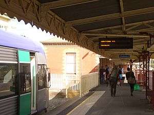
Rail transport includes both passenger rail and freight rail. The city's only station is Ararat's railway station which is on the Ararat railway line and is the terminal train station for the Ararat V/Line rail service. Twice daily peak VLocity services run to Ballarat (53 minutes) and on to Melbourne (133–143 minutes), with some trains stopping at stations in between. The rail station is at the junction of the Ararat line, the Western standard gauge railway and Avoca railway. The Overland runs to Melbourne twice weekly (140 minutes) and travel to Adelaide is also possible (16 hours).
A regional airport, Ararat Airport YARA (ARY) is located 5 km south of the city on the Western Highway and provides for general aviation.
Health

Ararat & District Hospital (established in 1850) is a major regional hospital and is coordinated by the East Grampians Health Service and Ararat Medical Centre.
Utilities
Water and waste-water services are supplied by Grampians-Wimmera-Mallee Water (GWMWater). Ararat's water supply source is a combination of Mt Cole Reservoir and Lake Fyans, with the smaller Langi Ghiran (Picnic Road) Reservoir also part of the water supply system.[34] Olivers Gully and Copes Hill reservoirs provide additional water storage.[35]
Notable people
- Air Chief Marshal Sir Frederick Scherger was born in Ararat on 18 May 1904
- Shane Kelly, Olympic cyclist and silver and bronze medalist
- Rene Kink, Australian Rules footballer
- Neil Murray, Ararat-born, Lake Bolac-raised singer-songwriter
- Harold Dunstan Gordon Ferres, Army officer, grazier and farmer (1885-1978)[36]
- Ada Elizabeth Corder, pianist and music teacher (1895-1987)[37]
- William McLellan, mining agent and politician (1831-1906)[38]
- John Eagle, Studio Potter
- Geoff Todd, Artist
- T.A. Wild, inventor of Wild's Ezy-Sauce.[39]
References
- ↑ Australian Bureau of Statistics (31 October 2012). "Ararat (UCL)". 2011 Census QuickStats. Retrieved 1 November 2012.
- ↑ "Statistics". Ararat Rural City Council. Retrieved 14 February 2015.
- ↑ http://abs.vic.gov.au
- ↑ "Hopkins Correctional Centre (Ararat) Precinct Development Plan". Corrections Victoria. November 2010. Retrieved 14 February 2015.
- 1 2 "Ararat Rural City". Profile.Id. 2012. Archived from the original on 9 March 2012. Retrieved 15 June 2016.
- ↑ "Post Office List". Premier Postal. Retrieved 11 August 2008.
- ↑ "Gum San Chinese Heritage Centre". Ararat Rural City Council. 2016. Retrieved 15 June 2016.
- ↑ "Tourism". Ararat Rural City Council. Retrieved 14 February 2015.
- ↑ "Destinations: Ararat". Tourism Victoria. Retrieved 31 January 2014.
- ↑ "Climate statistics for Ararat Prison". Bureau of Meteorology. Retrieved 10 February 2015.
- ↑ "Summary Profiles - Ararat Rural City Community Profile". Profile.Id. 2006. Archived from the original on 9 March 2012. Retrieved 15 June 2016.
- ↑ "Who do I speak to?". Ararat Rural City Council. Retrieved 14 February 2015.
- ↑ "Your Local Police: Ararat". Victoria Police. Archived from the original on 19 May 2016. Retrieved 15 June 2016.
- ↑ "Ararat Children's Court - Children's Court of Victoria". Victorian Government Directory. Retrieved 15 June 2016.
- ↑ "Ararat Magistrates' Court". Magistrates' Court of Victoria. Retrieved 15 June 2016.
- ↑ "Ararat". Federation University Australia. Retrieved 15 June 2016.
- ↑ "Ararat Training Centre". Melbourne Polytechnic. Retrieved 15 June 2016.
- ↑ "Town Hall". Heritage Victoria. Retrieved 14 February 2015.
- ↑ "Ararat Regional Art Gallery". Ararat Rural City Council. Retrieved 14 February 2015.
- ↑ "Ararat Performing Arts Centre". Ararat Rural City Council. Retrieved 14 February 2015.
- ↑ "Ararat". Full Points Footy. Archived from the original on 15 June 2010. Retrieved 15 June 2016.
- ↑ "Ararat Eagles". Full Points Footy. Archived from the original on 12 June 2010. Retrieved 15 June 2016.
- ↑ "Ararat Football Netball Club". Fox Sports Pulse. Retrieved 15 June 2016.
- ↑ "Wimmera Racing at Ararat". Country Racing Victoria. Archived from the original on 19 July 2008. Retrieved 7 May 2009.
- ↑ "Ararat". Australian Harness Racing. Retrieved 11 May 2009.
- ↑ "Ararat". Golf Select. Retrieved 11 May 2009.
- ↑ "Chalambar". Golf Select. Retrieved 11 May 2009.
- ↑ Scully, Sarah (16 October 2009). "Golden festival strikes it rich". Ararat Advertiser. Archived from the original on 6 March 2012. Retrieved 15 June 2016.
- ↑ "About". Ararat Jailhouse Rock Festival. Retrieved 15 June 2016.
- ↑ "The Biggest Loser 2014 to reach new heights". Network Ten. 20 November 2013. Retrieved 15 June 2016.
- ↑ "Ararat Lunatic Asylum". Aradale Ghost Tours. Archived from the original on 26 February 2016. Retrieved 15 June 2016.
- 1 2 "2006 Census Community Profiles: Ararat". Australian Bureau of Statistics. Retrieved 14 February 2015.
- ↑ "Ararat transit launched". Ararat Advertiser. yourguide.com.au. 13 May 2008. Archived from the original on 22 July 2008. Retrieved 1 August 2008.
- ↑ "Discussion Paper: Major reservoirs required following the completion of the Wimmera Mallee Pipeline". GWMWater. July 2007. p. 4. Retrieved 21 January 2015.
- ↑ "Water Quality Annual Report 2014/15". GWMWater. p. 6. Retrieved 21 January 2016.
- ↑ Smith, Neil (1996). "Ferres, Harold Dunstan Gordon (1885–1978)". Australian Dictionary of Biography. 14. Melbourne University Press. Retrieved 15 June 2016 – via National Centre of Biography, Australian National University.
- ↑ Matthews, Emma (2007). "Corder, Ada Elizabeth (1895–1987)". Australian Dictionary of Biography. 17. Melbourne University Press. Retrieved 15 June 2016 – via National Centre of Biography, Australian National University.
- ↑ Macintyre, Stuart (1974). "McLellan, William (1831–1906)". Australian Dictionary of Biography. 5. Melbourne University Press. Retrieved 15 June 2016 – via National Centre of Biography, Australian National University.
- ↑ "Historic Ararat: Walking and driving trails" (PDF). Ararat Rural City Council. p. 13. Retrieved 15 June 2016.
External links
| Wikimedia Commons has media related to Ararat, Victoria. |
| Wikivoyage has a travel guide for Ararat. |