Horsham, Victoria
| Horsham Victoria | |||||||
|---|---|---|---|---|---|---|---|
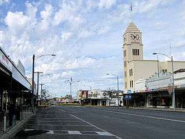 Firebrace Street, Horsham's main street, in 2006 | |||||||
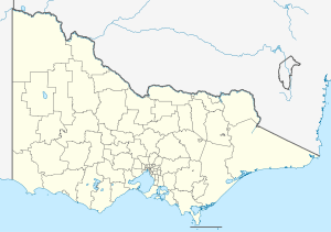 Horsham Location in Victoria | |||||||
| Coordinates | 36°43′S 142°12′E / 36.717°S 142.200°ECoordinates: 36°43′S 142°12′E / 36.717°S 142.200°E | ||||||
| Population | 16,451 (2015)[1] | ||||||
| Postcode(s) | 3400 | ||||||
| Elevation | 128 m (420 ft) | ||||||
| Location | |||||||
| LGA(s) | Rural City of Horsham | ||||||
| County | Borung | ||||||
| State electorate(s) | Lowan | ||||||
| Federal Division(s) | Mallee | ||||||
| |||||||
Horsham (/ˈhɔːrʃəm/, locally [ˈhoːʃəm])[2] is a regional city in the Wimmera region of western Victoria, Australia. Located on the Wimmera River, Horsham is approximately 300 kilometres (190 mi) north-west of the state capital Melbourne. In June 2015, Horsham had an estimated population of 16,451.[1] It is the most populous city in the Wimmera region, and it is the main administrative centre for the Rural City of Horsham local government area. And serves a catchment of approximately 95,000 people.
Horsham was named by original settler James Monckton Darlot after the town of Horsham in his native England. It grew throughout the latter 19th and early 20th century as a centre of Western Victoria's wheat and wool industry. Horsham was declared a city in 1949 and was named Australia's Tidiest Town in 2001 and again in 2015.[3]
History
The first inhabitants of the Horsham area were the Djura Balug indigenous Australian tribe who spoke the Jardwadjali language.[4]
Major Thomas Mitchell was the first European to pass through the area, naming the Wimmera River on 18 July 1836.
Squatter James Monckton Darlot was the first European settler, claiming 100,000 acres at Dooen on 10 August 1842.[5] Charles Carter established his property "Brim Springs" nearby in 1845.[6]
The Post Office opened on 1 July 1848.[7] An elaborate post office building and clock tower was erected in 1880.
The main railway from Melbourne reached Horsham in 1879 and was later extended to Adelaide, South Australia, while a branch line west to Carpolac was started in 1887 and closed in 1988.[8] The Horsham Borough Council and the Shire of Wimmera operated the McKenzie Creek Tramway from the town to a stone quarry, some 8 kilometres (5 mi) to the south. The horse tramway opened in 1885 and ceased operating in 1927. Special picnic trains operated from time to time conveying residents in open wagons.[9]
Major flooding affected the settlement in both October 1894 and August 1909 with the Wimmera reaching 3.87 m.
Horsham was declared a town on 17 November 1932.
Green Lake, originally planned as an agricultural irrigation reservoir was constructed in 1933 with a capacity of 5.35 GL.
Horsham was declared a city on 25 May 1949.
On 24 February 1951 a train collided with a bus at a level crossing near Horsham resulting in 11 deaths.[10]
A 1960s council by-law calling for the removal of verandahs from buildings had a significant effect on the streetscape, with notable verandahs demolished at The Royal[11] as well as The Exchange, The Bull and Mouth, and The White Hart. The Post Office was demolished in 1970 and replaced with a modern office block. The bell from the old post office was incorporated into a memorial.
The Rural City of Horsham was formed through amalgamation of surrounding shires on 20 January 1995.

The Black Saturday bushfires of 2009 affected Horsham, with 5,700 ha (14,000 acres) area burnt around the city's fringe including the golf club and eight homes.[12] The satellite town of Haven was worst affected.
It was named Australia's Tidiest Town in 2001[3] and was also named Victoria's tidiest town and national finalist in 2009.
Horsham experienced significant flooding in successive years in 2010 and 2011 Victorian floods. During these events, the Wimmera reached 3.32 m and 4.71 m respectively. The 2011 event was particularly severe with the Wimmera reaching a record peak level, over a thousand residents were evacuated as flood waters divided the city and damaged 600 houses pushing up to a metre of water into parts of the CBD.[13]
Geography
Horsham is situated on the floodplain of the Wimmera River, the topography of which is mostly flat. The locality is defined by a near perfect square area of 14 kilometres squared bordered by Riley Road/Davis Drive to the north; Cameron Road to the east; Kenny Road to the south; and Curran Road to the west. The mean elevation is 128 metres (420 ft) above sea level. The river at Horsham is its widest reach and forms an east-west green belt with several islands along the reach, the largest being the Apex island sand bank. This area is primarily urban, however the larger statistical area encompasses the agricultural land that surrounds the city. The river and its tributaries Burnt Creek One and Two are the only natural water feature of the city.

Land Use

The urban area extends both north and south of the river, the majority of which is used for residential and civic uses predominate in the north and industry in the south. More than 84% of Horsham's 6,987 residences are detached, well above the Australian average, and most recent suburban expansion has occurred just south of the river and the northern fringe.
The Central Business District (CBD) sits near its geographical centre with Firebrace Street forming its north-south spine and occupies approximately 21 blocks north of the river between Darlot and Urquhart street and Western Highway. The CBD and surrounds are laid out in a strict grid plan with wide streets and many roundabouts and traffic lights. Horsham lacks a prominent skyline, partly due to its flat topography and its large sprawling area of approximately 14 blocks. It contains mainly low-rise buildings. The State Government Offices on McLauchlin Street, at five stories, is the tallest building to roof.(two large brick mechanical service rooms on the roof bring its total floor count to 6 stories) Some architectural details are also prominent landmarks including T&G office building tower (approximately seven stories) and the spire of St Johns church (approximately eight stories) Horsham Town hall (approximately 4 stories to roof of fly-tower). Two telecommunication masts located adjacent the government offices are the tallest structure in the city.
Horsham plaza shopping centre is the main Shopping mall with approximately 30-35 stores. It is mainly a long strip mall design inside with a food court in the centre where it goes in three directions.
Horsham gateway centre is the other shopping center, consisting of approximately 12 stores. Its design has most shop entrances under a large freestanding architectural pagola and a large entrance in the centre, which enters Into a foodcourt, several specialty stores, a playland and a large target.
Horsham does not have suburbs, however the settlement of Haven 5 kilometres to the south is a satellite town. Other localities in the greater Horsham area include Bungalally (south east), Riverside and Drung (east), Dooen (north) and Vectis (west).
There are several large lakes to the east and west, with the eastern lakes being freshwater and the western lakes being mostly salt lakes or small seasonal salt pans. Green lake is an artificial lake (reservoir) built for irrigation, it is now a recreational lake.
Climate
Horsham is classified as a semi-arid climate (Köppen climate classification BSk) similar to Mildura although with less rain and drier for more of the year. As such, although its elevation makes it on average a degree cooler than Mildura, it can receive relatively more extremes of temperature.
| Climate data for Horsham Aerodrome (YHSM) since 1997 | |||||||||||||
|---|---|---|---|---|---|---|---|---|---|---|---|---|---|
| Month | Jan | Feb | Mar | Apr | May | Jun | Jul | Aug | Sep | Oct | Nov | Dec | Year |
| Record high °C (°F) | 46.0 (114.8) |
47.4 (117.3) |
41.0 (105.8) |
35.0 (95) |
28.0 (82.4) |
24.0 (75.2) |
20.0 (68) |
26.0 (78.8) |
31.0 (87.8) |
38.0 (100.4) |
42.3 (108.1) |
46.0 (114.8) |
47.4 (117.3) |
| Average high °C (°F) | 31.0 (87.8) |
30.5 (86.9) |
26.8 (80.2) |
22.2 (72) |
17.7 (63.9) |
14.4 (57.9) |
13.6 (56.5) |
15.2 (59.4) |
18.2 (64.8) |
21.6 (70.9) |
26.1 (79) |
28.4 (83.1) |
22.1 (71.8) |
| Average low °C (°F) | 12.5 (54.5) |
12.6 (54.7) |
10.0 (50) |
7.1 (44.8) |
5.1 (41.2) |
3.7 (38.7) |
3.2 (37.8) |
3.2 (37.8) |
4.5 (40.1) |
5.4 (41.7) |
8.6 (47.5) |
10.4 (50.7) |
7.2 (45) |
| Record low °C (°F) | 1.0 (33.8) |
2.5 (36.5) |
1.0 (33.8) |
−2.0 (28.4) |
−4.0 (24.8) |
−6.0 (21.2) |
−5.0 (23) |
−4.0 (24.8) |
−3.0 (26.6) |
−3.0 (26.6) |
−2.0 (28.4) |
1.0 (33.8) |
−6.0 (21.2) |
| Average precipitation mm (inches) | 28.7 (1.13) |
26.0 (1.024) |
14.7 (0.579) |
26.5 (1.043) |
31.3 (1.232) |
37.4 (1.472) |
41.2 (1.622) |
39.6 (1.559) |
36.8 (1.449) |
33.7 (1.327) |
32.8 (1.291) |
27.8 (1.094) |
374.8 (14.756) |
| Average rainy days | 2.8 | 2.6 | 2.6 | 3.9 | 6.1 | 6.8 | 8.1 | 7.6 | 7.1 | 5.2 | 4.5 | 3.8 | 61.1 |
| Source: [14] | |||||||||||||
Government
It is the seat of local government for the Horsham City Council which governs the Rural City of Horsham.
In the Legislative Assembly of Victoria it is represented by the Electoral district of Lowan.
In the Parliament of Australia it is represented in the Australian House of Representatives by the Division of Mallee. Currently held by the National party, it is the most conservative seat in the country.[15]
Culture
The Wesley Performing Arts Centre is the city's main performing arts venue located in the 1912 former Wesley Church. The Horsham Arts Council oversees theatre and performing arts productions. The Horsham Regional Art Gallery is the city's major civic gallery and is located in an old timber framed brick and masonry hall. The Horsham Performing Arts Centre was completed in 2015 and opened in February 2016 and includes a 500-seat main hall complete with 17-metre-high fly tower.
Festivals include the annual Horsham Country Music Festival,Kannamroo festival Art is...Festival, Spring Garden Festival, Awakenings (Australia's only regional disability arts festival[16]), as well as the biennial Nati Frinj Festival.
Horsham Botanic Gardens, located by the Wimmera River, were designed by notable landscape architect William Guilfoyle.
Horsham is the birth town of international model and actress, Portia de Rossi. However, the star moved to Geelong for her schooling.
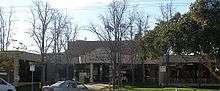
 Horsham Mechanics Institute
Sport
Sport and fitness are well-supported in Horsham. There are two well-equipped gyms, a large indoor stadium with facilities for netball, basketball and other indoor sports. There is an Aquatic centre with a 25-metre heated pool and gym facility. Local team sports are a very popular way of exercising.
There are two football and netball leagues based around Horsham – the Wimmera Football & Netball League and the Horsham & District Football & Netball League. The town has two Australian rules football teams competing in the Wimmera Football League; the Horsham Demons and the Horsham Saints. The Horsham Demons have had success in recent years having won the last 10 Wimmera Football League premierships until 2012. Kalkee have been the biggest grand final winners in the Horsham District League, in both football and netball, over the past 50 years. Footballer and 2014 Australian of the Year Adam Goodes grew up in Horsham where he worked at the cinema before being drafted to the Sydney Swans.
Cricket and tennis are the main summer sports played in Horsham. The Horsham Cricket Association has clubs based in the Horsham district including Laharum, Noradjuha, Quantong, Natimuk, Rupanyup, Minyip, Dimboola and Murtoa. There are a number of teams located in Horsham, being Homers, Horsham Saints, Jung Tigers and Colts.
There are various Volleyball facilities, with a weekly domestic competition run for enjoyment, and training programs run, in conjunction with Horsham's key secondary school, Horsham College. Teams from the College compete in the National Volleyball Schools Cup each year, and over previous years, have won various gold, silver and bronze medals, in both men's and women's, Division 2, Division 1 and Honours.
The horse racing club, the Wimmera Racing Club, schedules around five race meetings a year at Horsham including the Horsham Cup meeting in October.[17]
Horsham Harness racing Club conducts regular meetings at its racetrack in the city,[18] and the Horsham Greyhound racing Club holds regular meetings.[19]
Golfers play at the course of the Horsham Golf Club on Golf Course Road.[20]
The Horsham Flying Club[21] is the home of sport aviation and gliding in the Wimmera Mallee region of Victoria. The club had been formed in 1963 as Wimmera Soaring Club and later amalgamated with Wimmera Sports Aircraft Association. Horsham hosts the longest running gliding competition in Australia, Horsham Week,[22] held yearly in the first week of February since 1967.
Infrastructure
Wimmera Health provides health services including the Wimmera Hospital (former Horsham Base Hospital) located on Baillie Street.
Wimmera hospital is a Very large regional Hospital (mainly one story tall and 2-3 stories tall near the main kitchen for the hospital) And is the main hospital for the city of Horsham and the surrounding area. with the main center sitting on 70,000 square metres.
Transport
Road transport and the motor vehicle is the main form of transport. The Western Highway (connecting Melbourne to Adelaide) is the largest road system in the city. It connects with the Henty Highway (A200) (from Portland north towards Mildura) cross paths with the Wimmera Highway at the fringes of the central business district. The Wimmera-Henty Highway (B200) is the main northern road, connecting Horsham to Warracknabeal and the Sunraysia Highway (B220) to Mildura as well as the Wimmera Highway (B240) and St Arnaud. The Wimmera Highway continues west to Naracoorte, South Australia.

Rail transport includes both passenger rail and freight rail. The city's only station is Horsham railway station which is on the Melbourne–Adelaide railway is located approximately four blocks (1 km) north of the CBD. The Overland operates between the state capitals and stops in Horsham thrice a week in each direction for passengers. However, there is no direct connection to the Victorian broad gauge rail network. Long interstate freight trains regularly travel through the town, and a local container freight service is operated by QRNational for Wimmera Container Lines.[23] Until July 2008 it was operated by Pacific National, who cancelled it in April then gave it a three-month reprieve.[24][25]
V/Line operates a coach service to and from Horsham from various areas. Melbourne bound passengers board a train in Ararat to continue their journey. Public transport within Horsham is limited to the town bus service operated by 'Wimmera Roadways/Horsham Bus Lines/Horsham Transit', consisting of 4 buses and 6 routes, though usually only 2 city buses are active at any given time.
01. Albert street north.
02. Sunnyside.
03. Wawunna Road.
04. Williams Road/southbank.
05. Natimuk road/Horsham west.
06. Haven.
During holidays a third and sometimes 4th City bus are active giving tours of the City and its attractions.
Horsham Airport operates general aviation.
Horsham has two taxi companies, although they get calls from the depot at '30 Wawunna Road' it consists of approximately 10 taxi vehicles. Mainly wheelchair accessible vans or modified station wagons, from mid 2014 to mid-late 2015 the company upsized their fleet adding another 4 vehicles (1 wheelchair accessible.
Utilities
Water and waste-water services an are sre supplied by Grampians-Wimmera-Mallee Water (GWMWater). The town water supply is fully treated drinking water.[26] Horsham's primary water source is Lake Wartook, with a bore field at Laharum providing a supplementary supply source for the town when water levels are low.[27]
Notable People
- Jannik Blair a.k.a The Bizzness Current Australia men's national wheelchair basketball team 'The Rollers' Paralympic Silver medalist, 2014 World Gold Medalist
- Adam Goodes former Australian Football League player and Australian of the Year who grew up and did his schooling in Horsham
- Portia de Rossi (born Amanda Rogers), actress, married to Ellen DeGeneres
- Chris Crewther MP current Member for Dunkley in the Australian Federal Parliament, who grew up and did all his schooling in Horsham and Murtoa
- James Darlot named the city of Horsham
- Thomas Halfpenny first non-Indigenous resident of Horsham
- George Langlands first store-owner in Horsham. His arrival on 1 July 1849 is regarded as the starting date of the township of Horsham[28]
- Pauline Toner (1935-1989), first female Victorian Cabinet minister
References
- 1 2 "3218.0 – Regional Population Growth, Australia, 2014-15: Population Estimates by Significant Urban Area, 2005 to 2015". Australian Bureau of Statistics. Australian Bureau of Statistics. 30 March 2016. Retrieved 12 September 2016. Estimated resident population, 30 June 2015.
- ↑ Macquarie Dictionary, Fourth Edition (2005). Melbourne, The Macquarie Library Pty Ltd. ISBN 1-876429-14-3
- 1 2 HRCC. "Horsham Rural City Council". Archived from the original on 31 August 2007. Retrieved 30 October 2007.
- ↑ http://horsham.vic.au/about-horsham/history
- ↑ Peach, John. The Biggest Ever Gold-mining Swindle in the Colonies. pg 240
- ↑ "Carter, Charles (1797–1875)". Australian Dictionary of Biography. Australian National University. Retrieved 17 September 2009.
- ↑ Premier Postal History. "Post Office List". Retrieved 11 April 2008.
- ↑ "VR History". www.victorianrailways.net. Retrieved 16 July 2008.
- ↑ The McKenzie Creek Tramway Vanstan, K. Australian Railway Historical Society Bulletin, September 1974 pp202-207
- ↑ "Chronology of Australian train crashes". AAP. 6 June 2007.
- ↑ http://vhd.heritage.vic.gov.au/places/result_detail/68616
- ↑ "Death toll may reach more than 40: police". Fairfax Media. Melbourne: The Age. 7 February 2009. Retrieved 7 February 2009.
- ↑ Roberts, Greg (18 January 2011). "Sandbags stem Horsham flood crisis". The Sydney Morning Herald.
- ↑ "Climate statistics for Horsham". Australian Bureau of Meteorology. Retrieved 13 April 2013.
- ↑ Antony Green. "Mallee – Federal Election 2007". Retrieved 30 October 2007.
- ↑ Visit Horsham. "Events+Festivals". Retrieved 21 September 2013.
- ↑ Country Racing Victoria. "Wimmera Racing at Horsham". Archived from the original on 2007-09-13. Retrieved 7 May 2009.
- ↑ Australian Harness Racing. "Horsham". Retrieved 11 May 2009.
- ↑ Greyhound Racing Victoria. "Horsham". Archived from the original on 30 March 2009. Retrieved 15 April 2009.
- ↑ Golf Select. "Horsham". Retrieved 11 May 2009.
- ↑ "Horsham Flying Club".
- ↑ "Horsham Week gliding competition".
- ↑ "Rail to roll on". Wimmera Mail Times. yourguide.com.au. 28 July 2008. Retrieved 30 July 2008.
- ↑ "Rail freight woes spark crisis of confidence". ABC News. www.abc.net.au. Retrieved 16 July 2008.
- ↑ "Three month extension for Wimmera rail freight services". ABC News. www.abc.net.au. 24 April 2008. Retrieved 16 July 2008.
- ↑ "Drinking Water". GWMWater. Retrieved 2016-01-21.
- ↑ http://www.mailtimes.com.au/news/local/news/general/horsham-on-100-groundwater/1472973.aspx
- ↑ "History - Horsham, Victoria, Australia". horsham.vic.au. Retrieved 2016-08-25.