West Maui Mountains
| West Maui Volcano | |
|---|---|
| Mauna Kahalawai | |
 The Īʻao Needle in the West Maui Mountains | |
| Highest point | |
| Elevation | 5,788 ft (1,764 m) [1] |
| Prominence | 5,668 ft (1,728 m) [1] |
| Coordinates | 20°53′37″N 156°35′22″W / 20.89361°N 156.58944°WCoordinates: 20°53′37″N 156°35′22″W / 20.89361°N 156.58944°W |
| Geography | |
 West Maui Volcano | |
| Parent range | Hawaiian Islands |
| Topo map | USGS Kilohana (HI) |
| Geology | |
| Age of rock | 1.32 Mega-annum |
| Mountain type | Much eroded shield volcano |
| Volcanic arc/belt | Hawaiian-Emperor seamount chain |
| Last eruption | ? |
| Climbing | |
| Easiest route | ? |
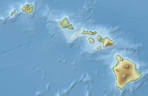
The West Maui Mountains or West Maui Volcano, known to the Hawaiians as Maui Komohana[2] and to geologists as Mauna Kahalawai, forms a much eroded shield volcano that constitutes the western one-quarter of the Hawaiian Island of Maui. Since its last eruption approximately 320,000 years ago, the West Maui Mountains have undergone substantial stream erosion.[3]
The three moku or districts of west Maui are Lāhaina, Kāʻanapali, and Wailuku.[4] Wailuku is also known as Pūʻalikomohana, or Nā Wai ʻEhā which means the four waters. The 4 waters are the ahupuaʻa (smaller land division than district), which are Waikapū, Wailuku, Waiʻehu, and Waiheʻe.
The port of Lāhainā lies on the southwestern slope.
The summit peak is called Puʻu Kukui, at 5,788 feet (1,764 m) elevation. Pu'u Kukui translates into "candlenut hill".[5]
Puʻu Kukui Watershed Preserve
Established in 1988, the Puʻu Kukui Preserve is the largest private nature preserve in the State of Hawaii. Since 1994, the 8,661-acre (35.05 km2) preserve has been managed by Maui Land & Pineapple Company in participation with The Nature Conservancy and the State Natural Area Partnership. These groups work together to protect the watershed lands of the West Maui mountain.
Geological history
The West Maui Mountains were formed through at least three series of major volcanic eruptions during its shield building period, starting 1.4 million years ago.[3] The mountains used to be over 13,000 feet high, but has collapsed and eroded down to a much smaller 5,100 feet. Rocks from the latest major shield-building eruptions are call the Honolua volcanics, which are roughly 500,000 years old. However, there were several re-juvenated stage eruptions more recently, the last dating to roughly 320,000 years ago.[3]
References
- 1 2 "Puu Kukui, Hawaii". Peakbagger.com. Retrieved 10 August 2014.
- ↑ A cultural-historical study of Ka'eo and other lands in Honua'ula, Island of Maui, KPA No. MaKaeo110
- 1 2 3 Sinton, John M. "Geologic History of Maui" (PDF). Hawaii Institute of Geophysics. Retrieved 18 August 2012.
- ↑ "Native Hawaiian Land Division". Haleakalā National Park. U.S. National Park Service.
- ↑ Pukui, Mary Kawena; Elbert, Samuel H.; Mookini, Esther T. Place Names of Hawaii. University of Hawaii. p. 200.
External links
Hawaiian volcanism topics (list) | ||
|---|---|---|
| Windward Isles | 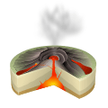 | |
| Leeward Isles | ||
| Emperor Seamounts | ||
| Topics | ||
Islands, municipalities, and communities of Maui County, Hawaii, United States | ||
|---|---|---|
| CDPs | 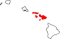 | |
| Unincorporated communities | ||
| Footnotes | ‡This populated place also has portions in an adjacent county or counties | |