Hawaii hotspot
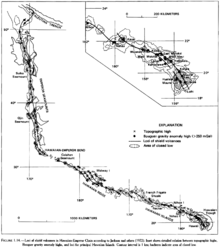
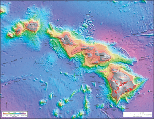
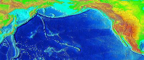 Bathymetry of the Hawaiian – Emperor seamount chain, showing the long volcanic chain generated by the Hawaii hotspot, starting in Hawaiʻi and ending at the Aleutian Trench. | |
 A diagram demonstrating the migration of the Earth's crust over the hotspot | |
| Country | United States |
|---|---|
| State | Hawaii |
| Region | North Pacific Ocean |
| Coordinates | 18°55′N 155°16′W / 18.92°N 155.27°W—Loihi Seamount, actual hotspot lies about 40 km (25 mi) southeastCoordinates: 18°55′N 155°16′W / 18.92°N 155.27°W—Loihi Seamount, actual hotspot lies about 40 km (25 mi) southeast |
The Hawaii hotspot is a volcanic hotspot located near the namesake Hawaiian Islands, in the northern Pacific Ocean. One of the most well-known and heavily studied hotspots in the world,[1][2] the Hawaii plume is responsible for the creation of the Hawaiian – Emperor seamount chain, a chain of volcanoes over 5,800 kilometres (3,600 mi) long. Four of these volcanoes are active, two are dormant, and more than 123 are extinct, many having since been ground beneath the waves by erosion as seamounts and atolls. The chain extends from south of the island of Hawaiʻi to the edge of the Aleutian Trench, near the eastern edge of Russia. While most volcanoes are created by geological activity at tectonic plate boundaries, the Hawaii hotspot is located far from plate boundaries. The classic hotspot theory, first proposed in 1963 by John Tuzo Wilson, proposes that a single, fixed mantle plume builds volcanoes that then, cut off from their source by the movement of the Pacific Plate, become increasingly inactive and eventually erode below sea level over millions of years. According to this theory, the nearly 60° bend where the Emperor and Hawaiian segments of the chain meet was caused by a sudden shift in the movement of the Pacific Plate. In 2003, fresh investigations of this irregularity led to the proposal of a mobile hotspot theory, suggesting that hotspots are mobile, not fixed, and that the 47-million-year-old bend was caused by a shift in the hotspot's motion rather than the plate's.
Ancient Hawaiians were the first to recognize the increasing age and weathered state of the volcanoes to the north as they progressed on fishing expeditions along the islands. The volatile state of the Hawaiian volcanoes and their constant battle with the sea was a major element in Hawaiian mythology, embodied in Pele, the deity of volcanoes. After the arrival of Europeans on the island, in 1880–1881 James Dwight Dana directed the first formal geological study of the hotspot's volcanics, confirming the relationship long observed by the natives. 1912 marked the founding of the Hawaiian Volcano Observatory by volcanologist Thomas Jaggar, initiating continuous scientific observation of the islands. In the 1970s, a mapping project was initiated to gain more information about the complex geology of Hawaii's seafloor.
The hotspot has since been tomographically imaged, showing it to be 500 to 600 km (310 to 370 mi) wide and up to 2,000 km (1,200 mi) deep, and olivine and garnet-based studies have shown its magma chamber is approximately 1,500 °C (2,730 °F). In its at least 85 million years of activity the hotspot has produced an estimated 750,000 km3 (180,000 cu mi) of rock. The chain's rate of drift has slowly increased over time, causing the amount of time each individual volcano is active to decrease, from 18 million years for the 76-million-year-old Detroit Seamount, to just under 900,000 for the one-million-year-old Kohala; on the other hand, eruptive volume has increased from 0.01 km3 (0.002 cu mi) per year to about 0.21 km3 (0.050 cu mi). Overall, this has caused a trend towards more active but quickly-silenced, closely spaced volcanoes—whereas volcanoes on the near side of the hotspot overlap each other (forming such superstructures as Hawaiʻi island and the ancient Maui Nui), the oldest of the Emperor seamounts are spaced as far as 200 km (120 mi) apart.
Theories
Tectonic plates generally focus deformation and volcanism at plate boundaries. However, the Hawaii hotspot is more than 3,200 kilometers (1,988 mi) from the nearest plate boundary;[1] while studying it in 1963, Canadian geophysicist J. Tuzo Wilson proposed the hotspot theory to explain these zones of volcanism so far from regular conditions,[3] a theory that has since come into wide acceptance.[4]
Wilson's stationary hotspot theory
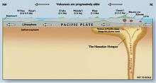
Wilson proposed that small, long lasting, exceptionally hot areas of magma exist under the Earth's surface; these heat centers create thermally active mantle plumes, which in turn sustain long-lasting volcanic activity. This "mid-plate" volcanism builds peaks that rise from relatively featureless sea floor, initially as seamounts as later as fully-fledged volcanic islands. Plate tectonics cause the local tectonic plate (in the case of the Hawaii hotspot, the Pacific Plate) to slowly slide over the hotspot, carrying its volcanoes with it without affecting the plume. Over hundreds of thousands of years, the magma supply for the volcano is slowly cut off, eventually going extinct. No longer active enough to overpower erosion, the volcano slowly sinks beneath the waves, becoming a seamount once again. As the cycle continues, a new volcanic center manifests, and a volcanic island arises anew. The process continues until the mantle plume itself collapses.[1]
This cycle of growth and dormancy strings together volcanoes over millions of years, leaving a trail of volcanic islands and seamounts across the ocean floor. According to Wilson's theory, the Hawaiian volcanoes should be progressively older and increasingly eroded the further they are from the hotspot, and this is easily observable; the oldest rock in the main Hawaiian islands, that of Kauaʻi, is about 5.5 million years old and deeply eroded, while the rock on Hawaiʻi island is a comparatively young 0.7 million years of age or less, with new lava constantly erupting at Kīlauea, the hotspot's present center.[1][5] Another consequence of his theory is that the chain's length and orientation serves as a record direction and speed of the Pacific Plate's movement. A major feature of the Hawaiian trail is a sudden 60° bend at a 40- to 50-million-year-old section of its length, and according to Wilson's theory, this is evidence of a major change in plate direction, one that would have initiated subduction along much of the Pacific Plate's western boundary.[6] This part of the theory has recently been challenged, and the bend might be attributed to the movement of the hotspot itself.[7]
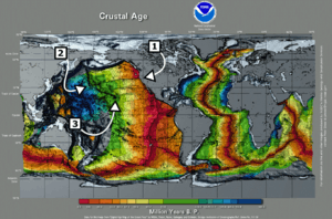
Geophysicists believe that hotspots originate at one of two major boundaries deep in the Earth, either a shallow interface in the lower mantle between an upper convecting layer and a lower non-convecting layer, or a deeper D'' ("D double-prime") layer, approximately 200 kilometres (120 mi) thick and immediately above the core-mantle boundary.[8] A mantle plume would initiate at the interface when the warmer lower layer heats a portion of the cooler upper layer. This heated, buoyant, and less-viscous portion of the upper layer would become less dense due to thermal expansion, and rise towards the surface as a Rayleigh-Taylor instability.[8] When the mantle plume reaches the base of the lithosphere, the plume heats it and produces melt. This magma then makes its way to the surface, where it is erupted as lava.[9]
Arguments for the validity of the hotspot theory generally center on the steady age progression of the Hawaiian islands and nearby features:[10] a similar bend in the trail of the Macdonald hotspot, the Austral–Marshall Islands seamount chain, located just south;[11] other Pacific hotspots following the same age-progressed trend from southeast to northwest in fixed relative positions;[12][13] and seismologic studies of Hawaii which show increased temperatures at the core–mantle boundary, evidencing a mantle plume.[14]
Shallow hotspot theory
Another hypothesis is that melting anomalies form simply as a result of lithospheric extension, which allows pre-existing melt to rise to the surface. These melting anomalies are called "hotspots" in plume theory, but this name pre-supposes the mantle source is unusually hot, a feature that has not been confirmed by observation. In the case of the Emperor-Hawaiian seamount chain, the Pacific plate boundary system was very different at ~ 80 Ma, when the Emperor seamount chain began to form. There is evidence that the chain started on a spreading ridge (the Pacific-Kula Ridge) that has now been subducted at the Aleutian trench.[15] The locus of melt extraction migrated off the ridge and into the plate interior, leaving a trail of volcanism behind it. This migration may have occurred because this part of the plate was extending in order to accommodate intraplate stress. Thus, a long-lived region of melt escape was sustained. Seismic tomography does not support the plume hypothesis. Notwithstanding the numerous papers that have been published citing seismological evidence for a plume in the region, these proposed plumes are all in different places, many of them tilting at high angles and in different directions, and some of them thousands of kilometers from the Big Island. No reliable image of a mantle plume extending down to the core–mantle boundary has been obtained.[16][17]
Moving hotspot theory
The most heavily challenged element of Wilson's theory is whether or not hotspots are indeed fixed relative to the overlying tectonic plates. Drill samples, collected by scientists as far back as 1963, suggest that the hotspot may have drifted over time, at the relatively rapid pace of about 4 centimeters (1.6 in) per year during the late Cretaceous and early Paleogene eras (81-47 Mya);[18] in comparison, the Mid-Atlantic Ridge spreads at a rate of 2.5 cm (1.0 in) per year.[1] In 1987, a study published by Peter Molnar and Joann Stock found that the hotspot does move relative to the Atlantic Ocean; however, they interpreted this as the result of the relative motions of the North American and Pacific plates rather than that of the hotspot itself.[19]
In 2001 the Ocean Drilling Program (since merged into the Integrated Ocean Drilling Program), an international research effort to study the world's seafloors, funded a two-month expedition aboard the research vessel JOIDES Resolution to collect lava samples from four submerged Emperor seamounts. The project drilled Detroit, Nintoku, and Koko seamounts, all of which are in the far northwest end of the chain, the oldest section.[20][21] These lava samples were then tested in 2003, suggested a mobile Hawaiian hotspot and a shift in its motion as the cause of the bend.[7][22] Lead scientist John Tarduno told National Geographic:
The Hawaii bend was used as a classic example of how a large plate can change motion quickly. You can find a diagram of the Hawaii – Emperor bend entered into just about every introductory geological textbook out there. It really is something that catches your eye."[22]
Despite the large shift, the change in direction was never recorded by magnetic declinations, fracture zone orientations or plate reconstructions; nor could a continental collision have occurred fast enough to produce such a pronounced bend in the chain.[23] To test whether or not the bend was a result of a change in direction of the Pacific Plate, scientists analyzed the lava samples' geochemistry to determine where and when they formed. Age was determined by the radiometric dating of radioactive isotopes of potassium and argon. Researchers estimated that the volcanoes formed during a period 81 million to 45 million years ago. Tarduno and his team determined where the volcanoes formed by analyzing the rock for the magnetic mineral magnetite. While hot lava from a volcanic eruption cools, tiny grains within the magnetite align with the Earth's magnetic field, and lock in place once the rock solidifies. Researchers were able to verify the latitudes at which the volcanoes formed by measuring the grains' orientation within the magnetite. Paleomagnetists concluded that the Hawaiian hotspot had drifted southward sometime in its history, and that, 47 million years ago, the hotspot's southward motion greatly slowed, perhaps even stopping entirely.[20][22]
History of study
Ancient Hawaiian
The possibility that the Hawaiian islands became older as one moved to the northwest was suspected by ancient Hawaiians long before Europeans arrived. During their voyages, seafaring Hawaiians noticed differences in erosion, soil formation, and vegetation, allowing them to deduce that the islands to the northwest (Niʻihau and Kauaʻi) were older than those to the southeast (Maui and Hawaii).[1] The idea was handed down the generations through the legend of Pele, the fiery Hawaiian Goddess of Volcanoes.
Pele was born to the female spirit Haumea, or Hina, who, like all Hawaiian gods and goddesses, descended from the supreme beings, Papa, or Earth Mother, and Wakea, or Sky Father.[24]:63[25] According to the myth, Pele originally lived on Kauai, when her older sister Nāmaka, the Goddess of the Sea, attacked her for seducing her husband. Pele fled southeast to the island of Oahu. When forced by Nāmaka to flee again, Pele moved southeast to Maui and finally to Hawaii, where she still lives in the Halemaumau Crater at the summit of Kīlauea. There she was safe, because the slopes of the volcano are so high that even Nāmaka's mighty waves could not reach her. Pele's mythical flight, which alludes to an eternal struggle between volcanic islands and ocean waves, is consistent with geologic evidence about the ages of the islands decreasing to the southeast.[1][18]
Modern studies
Three of the earliest recorded observers of the volcanoes were the Scottish scientists Archibald Menzies in 1794,[26] James Macrae in 1825,[27] and David Douglas in 1834. Just reaching the summits proved daunting: Menzies took three attempts to ascend Mauna Loa, and Douglas died on the slopes of Mauna Kea. The United States Exploring Expedition spent several months studying the islands in 1840–1841.[28] American geologist James Dwight Dana was on that expedition, as was Lieutenant Charles Wilkes, who spent most of the time leading a team of hundreds that hauled a pendulum to the summit of Mauna Loa to measure gravity. Dana stayed with missionary Titus Coan, who would provide decades of first-hand observations.[29] Dana published a short paper in 1852.[30]
Dana remained interested in the origin of the Hawaiian Islands, and directed a more in-depth study in 1880 and 1881. He confirmed that the islands' age increased with their distance from the southeastern-most island by observing differences in their degree of erosion. He also suggested that many other island chains in the Pacific showed a similar general increase in age from southeast to northwest. Dana concluded that the Hawaiian chain consisted of two volcanic strands, located along distinct but parallel curving pathways. He coined the terms "Loa" and "Kea" for the two prominent trends. The Kea trend includes the volcanoes of Kīlauea, Mauna Kea, Kohala, Haleakalā, and West Maui. The Loa trend includes Lōiʻhi, Mauna Loa, Hualālai, Kahoʻolawe, Lānaʻi, and West Molokaʻi. Dana proposed that the alignment of the Hawaiian Islands reflected localized volcanic activity along a major fissure zone. Dana's "great fissure" theory served as the working hypothesis for subsequent studies until the mid-20th century.[23]
Dana's work was followed up by geologist C. E. Dutton's 1884 expedition, who refined and expanded Dana's ideas. Most notably, Dutton established that the island of Hawaii actually harbored five volcanoes, whereas Dana counted three. This is because Dana had originally regarded Kīlauea as a flank vent of Mauna Loa, and Kohala as part of Mauna Kea. Dutton also refined others of Dana's observations, and is credited with the naming of 'a'ā and pāhoehoe-type lavas, although Dana had noted a distinction. Stimulated by Dutton's expedition, Dana returned in 1887, and published many accounts of his expedition in the American Journal of Science. In 1890 he published the most detailed manuscript of its day, and remained the definitive guide to Hawaiian volcanism for decades. 1909 saw the publication of two large volumes which extensively quoted from earlier works now out of circulation.[31]:154–155
In 1912 geologist Thomas Jaggar founded the Hawaiian Volcano Observatory. The facility was taken over in 1919 by the National Oceanic and Atmospheric Administration and in 1924 by the United States Geological Survey (USGS), which marked the start of continuous volcano observation on Hawaii island. The next century was a period of thorough investigation, marked by contributions from many top scientists. The first complete evolutionary model was first formulated in 1946, by USGS geologist and hydrologist Harold T. Stearns. Since that time, advances have enabled the study of previously limited areas of observation (e.g. improved rock dating methods and submarine volcanic stages).[31]:157[32]
In the 1970s, the Hawaiian seafloor was mapped using ship-based sonar. Computed SYNBAPS (Synthetic Bathymetric Profiling System)[33] data filled holes between the ship-based sonar bathymetric measurements.[19][34] From 1994 to 1998[35] the Japan Agency for Marine-Earth Science and Technology (JAMSTEC) mapped Hawaii in detail and studied its ocean floor, making it one of the world's best-studied marine features. The JAMSTEC project, a collaboration with USGS and other agencies, utilized manned submersibles, remotely operated underwater vehicles, dredge samples, and core samples.[36] The Simrad EM300 multibeam side-scanning sonar system collected bathymetry and backscatter data.[35]
Characteristics
Position
The Hawaii hotspot has been imaged through seismic tomography, and is estimated to be 500–600 km (310–370 mi) wide.[37][38] Recent diffraction tomography and high-resolution local tomography indicate a lower-mantle mantle plume, and a pond of plume material is evidenced by a large low-velocity zone in the upper mantle. These low seismic velocity zones often indicate hotter and more buoyant mantle material. A narrow low-velocity column extending downward from 670 to 1,500 km (420 to 930 mi) under Hawaii connects with a large low-velocity zone at 2,000 km (1,200 mi) on the boundary between the core and mantle north of Hawaiʻi, showing that the plume is tilted to a certain degree, deflected toward the south by mantle flow.[39] Uranium decay-series disequilibria data has shown that the actively flowing region of the melt zone is 220 ± 40 km (137 ± 25 mi) km wide at its base and 280 ± 40 km (174 ± 25 mi) at the upper mantle upwelling, consistent with tomographic measurements.[40]
Temperature
Indirect studies found that the magma chamber is located about 90–100 kilometers (56–62 mi) underground, which matches the estimated depth of the Cretaceous Period rock in the oceanic lithosphere; this may indicate that the lithosphere acts as a lid on melting by arresting the magma's ascent. The lava's original temperature was found in two ways, by testing garnet's melting point in lava and by adjusting the lava for olivine deterioration. Both USGS tests seem to confirm the temperature at about 1,500 °C (2,730 °F); in comparison, the estimated temperature for mid-ocean ridge basalt is about 1,325 °C (2,417 °F).[41]
The surface heat flow anomaly around the Hawaiian Swell is only of the order of 10 mW/m2,[42][43] far less than the continental United States range of 25 to 150 mW/m2.[44] This is unexpected for the classic model of a hot, buoyant plume in the mantle. However, it has been shown that other plumes display highly variable surface heat fluxes and that this variability may be due to variable hydrothermal fluid flow in the Earth's crust above the hotspots. This fluid flow advectively removes heat from the crust, and the measured conductive heat flow is therefore lower than the true total surface heat flux.[43] The low heat across the Hawaiian Swell indicates that it is not supported by a buoyant crust or upper lithosphere, but is rather propped up by the upwelling hot (and therefore less-dense) mantle plume that causes the surface to rise[42] through a mechanism known as "dynamic topography".
Movement
Hawaiian volcanoes drift northwest from the hotspot at a rate of about 5–10 centimeters (2.0–3.9 in) a year.[18] The hotspot has migrated south by about 800 kilometers (497 mi) relative to the Emperor chain.[23] Paleomagnetic studies support this conclusion based on changes in Earth's magnetic field, a picture of which was engrained in the rocks at the time of their solidification,[45] showing that these seamounts formed at higher latitudes than present-day Hawaii. Prior to the bend, the hotspot migrated an estimated 7 centimeters (2.8 in) per year; the rate of movement changed at the time of the bend to about 9 centimeters (3.5 in) per year.[23] The Ocean Drilling Program provided most of the current knowledge about the drift. The 2001[46] expedition drilled six seamounts and tested the samples to determine their original latitude, and thus the characteristics and speed of the hotspot's drift pattern in total.[47]
Each successive volcano spends less time actively attached to the plume. The large difference between the youngest and oldest lavas between Emperor and Hawaiian volcanoes indicates that the hotspot's velocity is increasing. For example, Kohala, the oldest volcano on Hawaii island, is one million years old and last erupted 120,000 years ago, a period of just under 900,000 years; whereas one of the oldest, Detroit Seamount, experienced 18 million or more years of volcanic activity.[21]
The oldest volcano in the chain, Meiji Seamount, perched on the edge of the Aleutian Trench, formed 85 million years ago.[48] At its current velocity, the seamount will be destroyed within a few million years, as the Pacific Plate slides under the Eurasian Plate. It is unknown whether the seamount chain has been subducting under the Eurasian Plate, and whether the hotspot is older than Meiji Seamount, as any older seamounts have since been destroyed by the plate margin. It is also possible that a collision near the Aleutian Trench had changed the velocity of the Pacific Plate, explaining the hotspot chain's bend; the relationship between these features is still being investigated.[23][49]
Magma

The composition of the volcanoes' magma has changed significantly according to analysis of the strontium–niobium–palladium elemental ratios. The Emperor Seamounts were active for at least 46 million years, with the oldest lava dated to the Cretaceous Period, followed by another 39 million years of activity along the Hawaiian segment of the chain, totaling 85 million years. Data demonstrate vertical variability in the amount of strontium present in both the alkalic (early stages) and tholeitic (later stages) lavas. The systematic increase slows drastically at the time of the bend.[48]
Almost all magma created by the hotspot is igneous basalt; the volcanoes are constructed almost entirely of this or the similar in composition but coarser-grained gabbro and diabase. Other igneous rocks such as nephelinite are present in small quantities; these occur often on the older volcanoes, most prominently Detroit Seamount.[48] Most eruptions are runny because basaltic magma is less viscous than magmas characteristic of more explosive eruptions such as the andesitic magmas that produce spectacular and dangerous eruptions around Pacific Basin margins.[7] Volcanoes fall into several eruptive categories. Hawaiian volcanoes are called "Hawaiian-type". Hawaiian lava spills out of craters and forms long streams of glowing molten rock, flowing down the slope, covering acres of land and replacing ocean with new land.[50]
Eruption frequency and scale
There is significant evidence that lava flow rates have been increasing. Over the last six million years they have been far higher than ever before, at over 0.095 km3 (0.023 cu mi) per year. The average for the last million years is even higher, at about 0.21 km3 (0.050 cu mi). In comparison, the average production rate at a mid-ocean ridge is about 0.02 km3 (0.0048 cu mi) for every 1,000 kilometers (621 mi) of ridge. The rate along the Emperor seamount chain averaged about 0.01 cubic kilometers (0.0024 cu mi) per year. The rate was almost zero for the initial five million or so years in the hotspot's life. The average lava production rate along the Hawaiian chain has been greater, at 0.017 km3 (0.0041 cu mi) per year.[23] In total, the hotspot has produced an estimated 750,000 cubic kilometers (180,000 cu mi) of lava, enough to cover California with a layer about 1.5 kilometers (1 mi) thick.[5][18][51][52][53]
The distance between individual volcanoes has shrunk. Although volcanoes have been drifting north faster and spending less time active, the far greater modern eruptive volume of the hotspot has generated more closely spaced volcanoes, and many of them overlap, forming such superstructures as Hawaiʻi island and the ancient Maui Nui. Meanwhile, many of the volcanoes in the Emperor seamounts are separated by 100 kilometers (62 mi) or even as much as 200 kilometers (124 mi).[52][53]
Topography and geoid
A detailed topographic analysis of the Hawaiian – Emperor seamount chain reveals the hotspot as the center of a topographic high, and that elevation falls with distance from the hotspot. The most rapid decrease in elevation and the highest ratio between the topography and geoid height are over the southeastern part of the chain, falling with distance from the hotspot, particularly at the intersection of the Molokai and Murray fracture zones. The most likely explanation is that the region between the two zones is more susceptible to reheating than most of the chain. Another possible explanation is that the hotspot strength swells and subsides over time.[34]
In 1953, Robert S. Dietz and his colleagues first identified the swell behavior. It was suggested that the cause was mantle upwelling. Later work pointed to tectonic uplift, caused by reheating within the lower lithosphere. However, normal seismic activity beneath the swell, as well as lack of detected heat flow, caused scientists to suggest dynamic topography as the cause, in which the motion of the hot and buoyant mantle plume supports the high surface topography around the islands.[42] Understanding the Hawaiian swell has important implications for hotspot study, island formation, and inner Earth.[34]
Volcanoes
Over its 85 million year history, the Hawaii hotspot has created at least 129 volcanoes, more than 123 of which are extinct volcanoes, seamounts, and atolls, four of which are active volcanoes, and two of which are dormant volcanoes.[21][47][54] They can be organized into three general categories: the Hawaiian archipelago, which comprises most of the U.S. state of Hawaii and is the location of all modern volcanic activity; the Northwestern Hawaiian Islands, which consist of coral atolls, extinct islands, and atoll islands; and the Emperor Seamounts, all of which have since eroded and subsided to the sea and become seamounts and guyots (flat-topped seamounts).[55]
Volcanic characteristics

Hawaiian volcanoes are characterized by frequent rift eruptions, their large size (thousands of cubic kilometers in volume), and their rough, decentralized shape. Rift zones are a prominent feature on these volcanoes, and account for their seemingly random volcanic structure.[56] The tallest mountain in the Hawaii chain, Mauna Kea, rises 4,205 meters (13,796 ft) above mean sea level. Measured from its base on the seafloor, it is the world's tallest mountain, at 10,203 meters (33,474 ft); Mount Everest rises 8,848 meters (29,029 ft) above sea level.[57] Hawaii is surrounded by a myriad of seamounts; however, they were found to be unconnected to the hotspot and its volcanism.[36] Kīlauea has erupted continuously since 1983 through Puʻu ʻŌʻō, a minor volcanic cone, which has become an attraction for volcanologists and tourists alike.[58]
Landslides
The Hawaiian islands are carpeted by a large number of landslides sourced from volcanic collapse. Bathymetric mapping has revealed at least 70 large landslides on the island flanks over 20 km (12 mi) in length, and the longest are 200 km (120 mi) long and over 5,000 km3 (1,200 cu mi) in volume. These debris flows can be sorted into two broad categories: slumps, mass movement over slopes which slowly flatten their originators, and more catastrophic debris avalanches, which fragment volcanic slopes and scatter volcanic debris past their slopes. These slides have caused massive tsunamis and earthquakes, fractured volcanic massifs, and scattered debris hundreds of miles away from their source.[59]
Slumps tend to be deeply rooted in their originators, moving rock up to 10 km (6 mi) deep inside the volcano. Forced forward by the mass of newly ejected volcanic material, slumps may creep forward slowly, or surge forward in spasms that have caused the largest of Hawaii's historical earthquakes, in 1868 and 1975. Debris avalanches, meanwhile, are thinner and longer, and are defined by volcanic amphitheaters at their head and hummocky terrain at their base. Rapidly moving avalanches carried 10 km (6 mi) blocks tens of kilometers away, disturbing the local water column and causing a tsunami. Evidence of these events exists in the form of marine deposits high on the slopes of many Hawaiian volcanoes,[59] and has marred the slopes of several Emperor seamounts, such as Daikakuji Guyot and Detroit Seamount.[21]
Evolution and construction
Hawaiian volcanoes follow a well-established life cycle of growth and erosion. After a new volcano forms, its lava output gradually increases. Height and activity both peak when the volcano is around 500,000 years old and then rapidly decline. Eventually it goes dormant, and eventually extinct. Erosion then weathers the volcano until it again becomes a seamount.[55]
This life cycle consists of several stages. The first stage is the submarine preshield stage, currently represented solely by Lōʻihi Seamount. During this stage, the volcano builds height through increasingly frequent eruptions. The sea's pressure prevents explosive eruptions. The cold water quickly solidifies the lava, producing the pillow lava that is typical of underwater volcanic activity.[55][60]
As the seamount slowly grows, it goes through the shield stages. It forms many mature features, such as a caldera, while submerged. The summit eventually breaches the surface, and the lava and ocean water "battle" for control as the volcano enters the explosive subphase. This stage of development is exemplified by explosive steam vents. This stage produces mostly volcanic ash, a result of the waves dampening the lava.[55] This conflict between lava and sea influences Hawaiian mythology.[24]:8–11
The volcano enters the subaerial subphase once it is tall enough to escape the water. Now the volcano puts on 95% of its above-water height over roughly 500,000 years. Thereafter eruptions become much less explosive. The lava released in this stage often includes both pāhoehoe and ʻaʻā, and the currently active Hawaiian volcanoes, Mauna Loa and Kīlauea, are in this phase. Hawaiian lava is often runny, blocky, slow, and relatively easy to predict; the USGS tracks where it is most likely to run, and maintains a tourist site for viewing the lava.[55][61]
After the subaerial phase the volcano enters a series of postshield stages involving subsidence and erosion, becoming an atoll and eventually a seamount. Once the Pacific Plate moves it out of the 20 °C (68 °F) tropics, the reef mostly dies away, and the extinct volcano becomes one of an estimated 10,000 barren seamounts worldwide.[55][62] Every Emperor seamount is a dead volcano.
See also
- List of volcanic hotspots
- List of volcanoes in the Pacific Ocean
- List of volcanoes in the United States
- Maui Nui
- Types of volcanic eruptions
References
- 1 2 3 4 5 6 7 W. J. Kious; R. I. Tilling (1999) [1996]. This Dynamic Earth: the Story of Plate Tectonics (1.14 ed.). United States Geological Survey. ISBN 0-16-048220-8. Retrieved 2009-06-29.
- ↑ H. Altonn (2000-05-31). "Scientists dig for clues to volcano's origins: Lava evidence suggests Koolau volcano formed differently from others in the island chain". Honolulu Star-Bulletin. University of Hawaii—School of Ocean and Earth Science and Technology. Retrieved 2009-06-21.
- ↑ J. T. Wilson (1963). "A possible origin of the Hawaiian Islands". Canadian Journal of Physics. NRC Research Press. 41 (6): 863–870. Bibcode:1963CaJPh..41..863W. doi:10.1139/p63-094.
- ↑ G. D. Garland (1995). "John Tuzo Wilson: 24 October 1908-15 April 1993". Biographical Memoirs of Fellows of the Royal Society. Royal Society. 41: 534–526. doi:10.1098/rsbm.1995.0032.
- 1 2 W. J. Kious; R. I. Tilling (1999) [1996]. "This Dynamic Earth: The long trail of the Hawaiian hotspot". Retrieved 2012-02-29.
- ↑ J. M. Whittaker, R. D. Müller; et al. (2007-10-05). "Major Australian-Antarctic Plate Reorganization at Hawaiian – Emperor Bend Time". Science. American Association for the Advancement of Science. 318 (5847): 83–86. Bibcode:2007Sci...318...83W. doi:10.1126/science.1143769. ISSN 0036-8075. PMID 17916729.
- 1 2 3 J. A. Tarduno; et al. (2003). "The Emperor Seamounts: Southward Motion of the Hawaiian Hotspot Plume in Earth's Mantle" (PDF). Science. American Association for the Advancement of Science. 301 (5636): 1064–1069. Bibcode:2003Sci...301.1064T. doi:10.1126/science.1086442. PMID 12881572.
- 1 2 D. L. Turcotte; G. Schubert (2001). "1". Geodynamics (2 ed.). Cambridge University Press. pp. 17, 324. ISBN 0-521-66624-4.
- ↑ "Heat is deep and magma is shallow in a hot-spot system". Hawaii Volcano Observatory—United States Geological Survey. 2001-06-18. Retrieved 2009-03-29.
- ↑ V. Clouard; A. Bonneville (2005). "Ages of seamounts, islands, and plateaus on the Pacific plate". Geological Society of America Special Papers. Geological Society of America. 388: 71–90. doi:10.1130/0-8137-2388-4.71. ISBN 0-8137-2388-4.
- ↑ W. J. Morgan; J. P. Morgan. "Plate velocities in hotspot reference frame: electronic supplement" (PDF). Retrieved 2010-04-23.
- ↑ R. Keller (2009-04-09). "Seamounts in the Eastern Gulf of Alaska: A Volcanic Hotspot with a Twist?". National Oceanic and Atmospheric Administration. Retrieved 2009-06-06.
- ↑ C. Doglioni; M. Cuffaro (2005-10-01). "The hotspot reference frame and the westward drift of the lithosphere". Retrieved 2009-06-07.
- ↑ D. DePaolo; M. Manga (2003-05-09). "Deep Origin of Hotspots—the Mantle Plume Model" (PDF). Retrieved 2009-06-06.
- ↑ A. D. Smith (April 2003). "A Reappraisal of Stress Field and Convective Roll Models for the Origin and Distribution of Cretaceous to Recent Intraplate Volcanism in the Pacific Basin". International Geology Review. Taylor & Francis. 45 (4): 287–302. doi:10.2747/0020-6814.45.4.287. ISSN 0020-6814.
- ↑ I. O. Norton (2006-01-24). "Speculations on tectonic origin of the Hawaii hotspot". Retrieved 2009-05-30.
- ↑ G.R. Foulger; et al. (2013). "Caveats on Tomographic Images" (PDF). Terra Nova. 25 (4): 259–281. doi:10.1111/ter.12041.
- 1 2 3 4 M. O. Garcia; et al. (2006-05-16). "Geology, geochemistry and earthquake history of Lōʻihi Seamount, Hawaii". Chemie der Erde - Geochemistry. Elsevier. 66 (2): 81–108. Bibcode:2006ChEG...66...81G. doi:10.1016/j.chemer.2005.09.002. Retrieved 2012-02-26.
- 1 2 H. Rance (1999). Historical Geology: The Present is the Key to the Past (PDF). QCC Press. pp. 405–407. Retrieved 2009-06-29.
- 1 2 C. Uhlik (2003-01-08). "The 'fixed' hotspot that formed Hawaii may not be stationary, scientists conclude". Stanford Report. Stanford University. Retrieved 2009-04-03.
- 1 2 3 4 B. C. Kerr; D. W. Scholl; S. L. Klemperer (12 July 2005). "Seismic stratigraphy of Detroit Seamount, Hawaiian Emperor seamount chain: Post-hot-spot shield-building volcanism and deposition of the Meiji drift" (PDF). Geochemistry, Geophysics, Geosystems. Stanford University. 6 (7): n/a. Bibcode:2005GGG.....6.7L10K. doi:10.1029/2004GC000705. Retrieved 2012-02-25.
- 1 2 3 J. Roach (2003-08-14). "Hot Spot That Spawned Hawaii Was on the Move, Study Finds". National Geographic News. Retrieved 2009-03-09.
- 1 2 3 4 5 6 G. R. Foulger; D. L. Anderson. "The Emperor and Hawaiian Volcanic Chains: How well do they fit the plume hypothesis?". Retrieved 2009-04-01.
- 1 2 W. D. Westervelt (2008) [1916]. Hawaiian Legends of Volcanoes. Easy Reading Series. Forgotten Books. ISBN 978-1-60506-963-0. Retrieved 2009-06-30.
- ↑ S. Hune; G. M. Nomura (2003). Asian/Pacific Islander American women. NYU Press. p. 26. ISBN 0-8147-3633-5. Retrieved 2009-06-30.
- ↑ A. Menzies (1920). W. F. Wilson, ed. Hawaii Nei 128 Years Ago: Journal of Archibald Menzies, kept during his three visits to the Sandwich or Hawaiian Islands in the years 1792–1799. s.n. p. 197. Retrieved 2009-12-01.
- ↑ J. Macrae (1922). W. F. Wilson, ed. With Lord Byron at the Sandwich Islands in 1825: Being Extracts from the MS Diary of James Macrae, Scottish Botanist. s.n. ISBN 978-0-554-60526-5. Retrieved 2009-12-11.
- ↑ R. A. Sprague (1991). "Measuring the Mountain: the United States Exploring Expedition on Mauna Loa, 1840–1841". Hawaiian Journal of History. Hawaiian Historical Society, Honolulu. 25. hdl:10524/359.
- ↑ E. A. Kay (1997). "Missionary Contributions to Hawaiian Natural History: What Darwin Didn't Know". Hawaiian Journal of History. Hawaiian Historical Society, Honolulu. 31: 27–51. hdl:10524/170.
- ↑ J. D. Dana (1852). "Note on the eruption of Mauna Loa". American Journal of Science. Benjamin Silliman. 100: 254–257.
- 1 2 Robert W. Decker; Thomas L. Wright; Peter H. Stauffer, eds. (1987). Volcanism in Hawaii: papers to commemorate the 75th anniversary of the founding of the Hawaii Volcano Observatory. United States Geological Survey Professional Paper, 1350. 1. United States Geological Survey.
- ↑ R. A. Apple (4 January 2005). "Thomas A. Jaggar, Jr., and the Hawaiian Volcano Observatory". Hawaiian Volcano Observatory—United States Geological Survey. Retrieved 26 February 2012.
- ↑ R. J. Van Wyckhouse (1973). "Synthetic Bathymetric Profiling System (SYNBAPS)". Defense Technical Information Center. Retrieved 2009-10-25.
- 1 2 3 P. Wessel (1993). "Observational Constraints on Models of the Hawaiian Hot Spot Swell". Journal of Geophysical Research. American Geophysical Union / Johns Hopkins Press. 98 (B9): 16,095–16,104. Bibcode:1993JGR....9816095W. doi:10.1029/93JB01230. ISSN 0148-0227. OCLC 2396688. Archived from the original on 2000-10-20. Retrieved 2010-12-24.
- 1 2 "MBARI Hawaii Multibeam Survey". Monterey Bay Aquarium Research Institute. 1998. Retrieved 2009-03-29.
- 1 2 B. W. Eakens; et al. "Hawaii's Volcanoes Revealed" (PDF). United States Geological Survey. Retrieved 2009-03-28.
- ↑ Zhao, D (2004). "Global tomographic images of mantle plumes and subducting slabs: insight into deep Earth dynamics". Physics of the Earth and Planetary Interiors. 146 (1-2): 3. Bibcode:2004PEPI..146....3Z. doi:10.1016/j.pepi.2003.07.032.
- ↑ Y. Ji; H. Nataf (1998). "Detection of mantle plumes in the lower mantle by diffraction tomography: Hawaii". Earth and Planetary Science Letters. Elsevier. 159 (3-4): 99. Bibcode:1998E&PSL.159...99J. doi:10.1016/S0012-821X(98)00060-0.
- ↑ D. Zhao (November 2007). "Seismic images under 60 hotspots: Search for mantle plumes". Gondwana Research. Elsevier. 12 (4): 335–355. doi:10.1016/j.gr.2007.03.001.
- ↑ B. Bourdon; et al. (2006-12-07). "Insights into the dynamics of mantle plumes from uranium-series geochemistry". Nature. Nature Publishing Group. 444 (7120): 713–717. Bibcode:2006Natur.444..713B. doi:10.1038/nature05341. PMID 17151659.
- ↑ T. Sisson. "Temperatures and depths of origin of magmas fueling the Hawaiian volcanic chain". United States Geological Survey. Retrieved 2009-04-02.
- 1 2 3 R. P. Von Herzen; et al. (1989). "Heat Flow and the Thermal Origin of Hot Spot Swells: The Hawaiian Swell Revisited". Journal of Geophysical Research: Solid Earth. American Geophysical Union. 94 (B10): 13, 783–13, 799. Bibcode:1989JGR....9413783V. doi:10.1029/jb094ib10p13783.
- 1 2 Harris, Robert N.; McNutt, Marcia K. (2007). "Heat flow on hot spot swells: Evidence for fluid flow". Journal of Geophysical Research. 112 (B3): B03407. Bibcode:2007JGRB..11203407H. doi:10.1029/2006JB004299.
- ↑ "Heat Flow - A transfer of temperature". Southern Methodist University. Retrieved 2012-02-24.
- ↑ R. F. Butler (1992). Paleomagnetism: Magnetic Domains to Geologic Terranes (PDF). Blackwell Scientific Publications. Retrieved 2012-02-26.
- ↑ "Ocean Drilling Program Leg 197 – Scientific Prospectus – Motion of the Hawaiian Hotspot: a Paleomagnetic Test". Ocean Drilling Program. 2001-04-17. Retrieved 2009-04-11.
- 1 2 "Drilling Strategy". Ocean Drilling Program. Retrieved 2009-04-04.
- 1 2 3 M. Regelous; M. Regelous, A. W. Hofmann, W. Abouchami, and S. J. G. Galer (2003). "Geochemistry of Lavas from the Emperor Seamounts, and the Geochemical Evolution of Hawaiian Magmatism from 85 to 42 Ma". Journal of Petrology. Oxford University Press. 44 (1): 113–140. doi:10.1093/petrology/44.1.113.
- ↑ M.N. Shapiro, A.V. Soloviev, and G.V. Ledneva (2006). "Emperor subduction?". Retrieved 2009-04-01.
- ↑ D. O'Meara (2008). Volcano: A Visual Guide. Firefly Books. ISBN 978-1-55407-353-5.
- ↑ "SITE 1206". Ocean Drilling Program Database-Results of Site 1206. Ocean Drilling Program. Retrieved 2009-04-09.
- 1 2 "Site 1205 Background and Scientific Objectives". Ocean Drilling Program database entry. Ocean Drilling Program. Retrieved 2009-04-10.
- 1 2 D. A. Clauge and G. B. Dalrymple (1987). "The Hawaiian-Emperor volcanic chain: Part 1. Geologic Evolution". United States Geological Survey Professional Paper 1350. p. 23.
- ↑ K. Rubin; M. Garcia. "Reply to Ask-An-Earth-Scientist". University of Hawaii. Retrieved 2009-05-11.
- 1 2 3 4 5 6 "Evolution of Hawaiian Volcanoes". Hawaiian Volcano Observatory—United States Geological Survey. 1995-09-08. Retrieved 2009-03-07.
- ↑ "How Volcanoes Work: Shield Volcanoes". San Diego State University. Retrieved 2012-01-25.
- ↑ H. King. "Highest Mountain in the World". Retrieved 2009-07-04.
- ↑ M. O. Garcia; et al. (1996). "Petrology of lavas from the Puu Oo eruption of Kilauea Volcano: III. The Kupaianaha episode (1986–1992)". Bulletin of Volcanology. Springer. 58 (5): 359–379. Bibcode:1996BVol...58..359G. doi:10.1007/s004450050145.
- 1 2 J. G. Moore; et al. (1994-04-01). "Giant Hawaiian Underwater Landslides". Science. American Association for the Advancement of Science. 264 (5155): 46–47. Bibcode:1994Sci...264...46M. doi:10.1126/science.264.5155.46. JSTOR 2883819.
- ↑ J. W. Head III, L. Wilson; Wilson (2003). "Deep submarine pyroclastic eruptions: theory and predicted landforms and deposits" (PDF). Journal of Volcanology and Geothermal Research. Elsevier. 121 (3–4): 155–193. Bibcode:2003JVGR..121..155H. doi:10.1016/S0377-0273(02)00425-0. Retrieved 2012-02-26.
- ↑ "Recent Kīlauea Status Reports, Updates, and Information Releases". United States Geological Survey—Hawaiian Volcano Observatory. Retrieved 2009-03-15.
- ↑ Britannica Summary "Seamounts" Check
|url=value (help). Encyclopædia Britannica. Britannica.com Inc. 1913. Retrieved 2009-03-15.
External links
- Pele-Goddess of Fire—Details Pele's full story, according to Hawaiian myths.
- The long trail of the Hawaiian hotspot—USGS article on the Hawaiian island chain.
- Evolution of Hawaiian Volcanoes—USGS article on the evolution of Hawaiian volcanoes over time.
- The short film Inside Hawaiian Volcanoes (1989) is available for free download at the Internet Archive
| Wikimedia Commons has media related to Hawaii hotspot. |
Hawaiian volcanism topics (list) | ||
|---|---|---|
| Windward Isles | 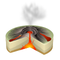 | |
| Leeward Isles | ||
| Emperor Seamounts | ||
| Topics | ||