West Chesterfield, New Hampshire
| West Chesterfield, New Hampshire | |
|---|---|
| Unincorporated community | |
 West Chesterfield  West Chesterfield | |
| Coordinates: 42°54′15″N 72°30′56″W / 42.90417°N 72.51556°WCoordinates: 42°54′15″N 72°30′56″W / 42.90417°N 72.51556°W | |
| Country | United States |
| State | New Hampshire |
| County | Cheshire |
| Town | Chesterfield |
| Elevation | 364 ft (111 m) |
| Time zone | Eastern (EST) (UTC-5) |
| • Summer (DST) | EDT (UTC-4) |
| ZIP code | 03466 |
| Area code(s) | 603 |
| GNIS feature ID | 870763[1] |
West Chesterfield is an unincorporated community in the town of Chesterfield in Cheshire County, New Hampshire, United States. It is located north of New Hampshire Route 9 in a valley leading to the Connecticut River. Via Route 9, Brattleboro, Vermont, is 3 miles (5 km) to the west, and Keene, New Hampshire, is 14 miles (23 km) to the east.
West Chesterfield has a separate ZIP code (03466) from the rest of Chesterfield.
References
Municipalities and communities of Cheshire County, New Hampshire, United States | ||
|---|---|---|
| City | 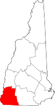 | |
| Towns | ||
| CDPs | ||
| Other villages | ||
This article is issued from Wikipedia - version of the 7/11/2016. The text is available under the Creative Commons Attribution/Share Alike but additional terms may apply for the media files.