Watson, Saskatchewan
| Watson | |
|---|---|
| Town | |
|
Main Street | |
| Motto: Industrial Crossroads of Saskatchewan | |
 Watson  Watson Location in Saskatchewan | |
| Coordinates: 52°7′N 104°31′W / 52.117°N 104.517°WCoordinates: 52°7′N 104°31′W / 52.117°N 104.517°W | |
| Country | Canada |
| Provinces and territories of Canada | Saskatchewan |
| Rural Municipalities (R.M.) | Lakeside |
| Post office founded (as Vossen) | 1904-04-01 |
| Incorporated (village) | 1906-05-01 |
| Incorporated (town) | August 1, 1908 |
| Government | |
| • Mayor | Norma Weber |
| Area | |
| • Total | 2.83 km2 (1.09 sq mi) |
| Population (2011) | |
| • Total | 777 |
| • Density | 274.7/km2 (711/sq mi) |
| [1][2][3][4][5] | |

Watson is a town of 777 residents in the rural municipality of Lakeside, in the Canadian province of Saskatchewan. Watson is located on the intersection of Highway 5 and Highway 6, the Canam Highway. Watson is approximately the same distance from Saskatoon which is to the west, and Regina to the south, which gives rise to its town motto, Industrial Crossroads of Saskatchewan.
History
Settlers began arriving in the early 1900s, many of them German American Catholics.[6] The first post office in the area was established on April 1, 1904 and named Vossen after its postmaster, Frank J. Vossen Jr.[7] It was changed to Watson on May 1, 1906, in advance of the village's incorporation on October 6, 1906.[1] The village became a town on August 1, 1908.[8] The town's namesake is Senator Robert Watson. Senator Watson, originally owned the land the town was built on.[9] Watson celebrated its first Santa Claus Day in 1932, and in 1996 erected a 25-foot (7.6 m)-high Santa Claus to commemorate the event.[10][11][12]
Demographics
| ||||||||||||||||||||||||||||||||||||
Geography
- Lat (DM) 52° 7' N
- Long (DM) 104° 31' W
- Dominion Land Survey Vossen Sec.16, Twp.37, R.18, W2
- Dominion Land Survey Watson Sec.28, Twp.36, R.18, W2
- Time zone (cst) UTC−6
Jansen Lake, Houghton Lake, Lenore Lake, Ironspring Creek, Big Quill Lake and Little Quill Lake are all close to Watson.
Sites of interest
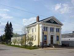

- The Canadian Bank of Commerce was constructed in 1906 in the Greek Revival style and was designated a National Historic Site in 1977.[12] The building was prefabricated by B.C. Mills, Timber & Trading Company and then assembled on site. This established the presence of the bank in the area before other banks arrived.[16] It now houses the Watson and District Heritage Museum.
- McNab Regional Park is a nearby campground facility with swimming pool, playground, and golf course.
Transportation
The town is located at the junction of Saskatchewan Highway 5 and Saskatchewan Highway 6.
The Saskatchewan Transportation Company provides inter-city bus service to the town.[17]
Railway
Melfort Subdivision C.P.R—serves Lanigan, Leroy, Watson, Spalding[18]
Notable Watsonians
- Dustin Tokarski – NHL Goaltender
- Ross Lonsberry – NHL Player
- Max McNab – NHL Player, Coach, GM
- Rod Gantefoer – Legislative Assembly of Saskatchewan MLA, Finance Minister
References
- 1 2 "Urban Municipality Incorporations" (PDF). Saskatchewan Ministry of Municipal Affairs. Retrieved 2011-04-25.
- ↑ "2011 Community Profiles". Statistics Canada. Government of Canada. Retrieved 2014-04-09.
- ↑ National Archives, Archivia Net. "Post Offices and Postmasters". Retrieved 2014-07-15.
- ↑ Government of Saskatchewan, MRD Home. "Municipal Directory System". Retrieved 2014-07-15.
- ↑ Commissioner of Canada Elections, Chief Electoral Officer of Canada (2005). "Elections Canada On-line". Retrieved 2014-07-15.
- ↑ McLennan, David (2006). "Watson". Encyclopedia of Saskatchewan. Canadian Plains Research Center, University of Regina. Retrieved 2011-04-25.
- ↑ "Watson". Post Offices and Postmasters. Library and Archives Canada. January 31, 2007. Retrieved 2011-04-25.
- ↑ "Watson: Incorporating Village as a Town" (PDF). Government of Saskatchewan. August 1, 1908. Retrieved 2011-04-25.
- ↑ "Community Profiles: Watson". SaskBiz. Enterprise Saskatchewan. 2009. Retrieved 2011-04-25.
- ↑ Solonyka, Ed. "Santa Claus Watson, Saskatchewan". Large Canadian Roadside Attractions. Retrieved 2011-04-25.
- ↑ Yanciw, David (September 17, 2002). "Town of Watson". Big Things: The Monuments of Canada. Retrieved 2011-04-25.
- 1 2 "Tourism". Town of Watson. 2010. Retrieved 2011-04-25.
- ↑ "2011 Community Profiles". Canada 2011 Census. Statistics Canada. July 5, 2013. Retrieved 2012-07-08.
- ↑ "2006 Community Profiles". Canada 2006 Census. Statistics Canada. March 30, 2011. Retrieved 2009-02-24.
- ↑ "2001 Community Profiles". Canada 2001 Census. Statistics Canada. February 17, 2012. Retrieved 2011-07-17.
- ↑ "Heritage Property Details" (PDF). Retrieved 2011-04-25.
- ↑ "Saskatchewan Transportation Company: Route Map" (PDF). Saskatchewan Transportation Company. February 2011. Retrieved 2011-04-25.
- ↑ Waghorn, J.R. (January 1925). Waghorn's Guide. Winnipeg: The Guide Co. Retrieved 2011-04-25.
External links
- Official website
- History of the Watson Museum
- Saskatchewan Cemeteries Project - Sacred Heart Cemetery, Watson ...
- 2006 Community Profiles
 |
Spalding | | ||
| Englefeld-Humboldt | |
Wadena-Quill Lake | ||
| ||||
| | ||||
| Jansen |