Wasleys, South Australia

Wasleys is a small town north-west of Gawler, South Australia. Roseworthy College is located around 6 km (3.7 mi) south of the town. At the 2011 census, Wasleys had a population of 372.[1]
History
The town of Wasleys was established in an area known as the Mudla Wirra Forest. The name Mudla Wirra is aboriginal, Mudla meaning "implement" and Wirra meaning "forest". The town of Wasleys is now situated on an area first known as "Ridleyton" which was named after John Ridley, who laid out the village of Ridley in 1873. In 1869, the Peterborough railway line was built through the region and a railway station was erected on the land purchased by Josiah Wasley, one of the first settlers to the area.
The township was advertised to attract people seeking good agricultural land as "Ridley Township - Wasleys Station". In time two townships were announced and called Ridleyton and Wasley. As the towns grew the name Ridleyton was discarded and the town became known as Wasleys.
Early settlers soon made their mark on the history of the region. In 1843, John Ridley revolutionised the agricultural industry with the first "stripper machine". In the 1860s, a local farmer named Charles Mullen created a method of ploughing which was known as "Mullenising". Mullen invented an implement, used throughout Australia, which was the precursor of the stump-jump plough. During 1866-1877, pioneer farmer Richard Marshall succeeded in solving the "red rust" problem in wheat by crossbreeding various wheat varieties and improved soil conditions using bone meal on the land. After good crop returns, a student at Roseworthy College named Charles Deland, led a campaign in favour of fertilizer.
In 1873, the township had been fully laid out and a local newspaper publicised the achievement in a short article about "Wasley" stating "There can be no question that this is an excellent locality for a township".[2] On 12 April 1970 a bus collided with a passenger train on the road from Wasleys to Gawler killing 17 people and injuring 45.
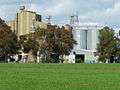
Wasleys became a thriving centre and once operated three chaff mills. Although the chaff mills have ceased operating, the town is still a focal point for agriculture and farming livestock, and as reported in 85% of all residents were born in Australia, 10% in the UK, and the remaining 5% in other countries.
In 2015, the Pinery bushfire burned through the township of Wasleys, gutting the lawn bowls club and post office.[3]
Gallery
 Wasley
 Hotel
Hotel Wasley Institute
 Oval
Oval Light River
References
- 1 2 Australian Bureau of Statistics (31 October 2012). "Wasleys (L) (Urban Centre/Locality)". 2011 Census QuickStats. Retrieved 22 January 2013.
- ↑ "Wasley Township". The Bunyip. Gawler. 27 September 1873.
[...] Mr. Wilkinson has in hand the sale of township lands near the Wasley Railway Station. The township has been laid out [...] and is very conveniently situated on the north side of the Mallala and Templers road [...] There can be no question that this is an excellent locality for a township, were there no special argument in favor of it; but, with so important a commercial feature as the Railway Station adjoining, we have long been surprised that a township has not [already] originated at so convenient a spot.
- ↑ "SA bushfires mapped: What happened where". ABC News. Australian Broadcasting Corporation. 26 November 2015. Retrieved 24 May 2016.
| Wikimedia Commons has media related to Wasleys, South Australia. |