Ebenezer, South Australia
| Ebenezer South Australia | |||||||||||||
|---|---|---|---|---|---|---|---|---|---|---|---|---|---|
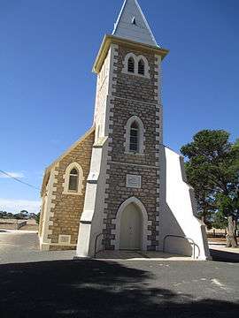 Ebenezer St John's Lutheran church | |||||||||||||
 Ebenezer | |||||||||||||
| Coordinates | 34°25′20″S 139°2′0″E / 34.42222°S 139.03333°ECoordinates: 34°25′20″S 139°2′0″E / 34.42222°S 139.03333°E | ||||||||||||
| Established | 1852 | ||||||||||||
| Postcode(s) | 5355 | ||||||||||||
| Location | |||||||||||||
| LGA(s) | Light Regional Council | ||||||||||||
| State electorate(s) | Stuart | ||||||||||||
| Federal Division(s) | Wakefield | ||||||||||||
| |||||||||||||
Ebenezer is a locality in the northern Barossa Valley of South Australia. It includes the historic Ebenezer settlement settled by 72 Wendish Lutherans who had migrated from Silesia in January 1852.[1] It also includes the nearby Neukirch settlement founded in 1854 by another group of Lutheran immigrants.[2]

Neukirch Lutheran church in March 2015
In either 1868 or 1869, 56 German settlers left Ebenezer in 14 covered wagons and two spring carts to settle in the town of Walla Walla in the Riverina area of New South Wales.[3]
Ebenezer originally started in 1851 a private sub-division in the cadastral unit of the Hundred of Belvidere. Boundaries were created for the “long established name” in 2000.[4]
References
| Wikimedia Commons has media related to Ebenezer, South Australia. |
- ↑ "Ebenezer Lutheran Church". Nuriootpa Lutheran Parish. Retrieved 6 February 2015.
- ↑ "Neukirch Lutheran Church". Nuriootpa Lutheran Parish. Retrieved 6 February 2015.
- ↑ "Walla Walla". Greater Hume Shire. Retrieved 9 February 2016.
- ↑ "Search result for " Ebenezer (LOCB)" (Record no SA0044754) with the following layers selected - "Suburbs and Localities" and " Place names (gazetteer)"". Property Location Browser. Government of South Australia. Retrieved 8 August 2016.
This article is issued from Wikipedia - version of the 8/7/2016. The text is available under the Creative Commons Attribution/Share Alike but additional terms may apply for the media files.