Gawler Belt, South Australia
| Gawler Belt South Australia | |||||||||||||
|---|---|---|---|---|---|---|---|---|---|---|---|---|---|
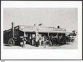 Gawler Belt Inn in 1880 | |||||||||||||
 Gawler Belt | |||||||||||||
| Coordinates | 34°36′S 138°42′E / 34.6°S 138.7°ECoordinates: 34°36′S 138°42′E / 34.6°S 138.7°E | ||||||||||||
| Postcode(s) | 5118 | ||||||||||||
| Location | 4 km (2 mi) NW of Gawler | ||||||||||||
| LGA(s) | Light Regional Council | ||||||||||||
| State electorate(s) | Electoral district of Light | ||||||||||||
| Federal Division(s) | Division of Wakefield | ||||||||||||
| |||||||||||||
Gawler Belt is a locality to the northwest of Gawler in South Australia. The area is predominantly rural in character, although most of the area is now too small allotments to farm profitably, so it is essentially a rural and industrial suburb of Gawler.
Gawler Belt is bounded on its southeast side by the Gawler bypass road and Sturt Highway. It is crossed by the now-unused Roseworthy railway line, but there has never been a station in Gawler Belt.[1] The Gawler Belt Inn stood approximately where the Redbanks Road interchange on the Gawler Bypass is now,[2] however the hotel was closed well before the bypass was built. The Inn operated from 1857 until 1913.[3]
References
- ↑ "Placename Details: Gawler Belt". Property Location Browser. Department of Planning, Transport and Infrastructure. 2 November 2006. SA0025586. Retrieved 26 August 2015.
- ↑ "Gawler History". Retrieved 26 August 2015.
- ↑ "Gawler Belt Inn". Now&Then Gawler. Gawler History Team Inc. Retrieved 26 August 2015.
This article is issued from Wikipedia - version of the 11/26/2015. The text is available under the Creative Commons Attribution/Share Alike but additional terms may apply for the media files.