Virginia State Route 71
| ||||
|---|---|---|---|---|
 | ||||
| Route information | ||||
| Maintained by VDOT | ||||
| Length: | 35.82 mi[1][2] (57.65 km) | |||
| Existed: | 1933 – present | |||
| Major junctions | ||||
| South end: |
| |||
|
| ||||
| North end: |
| |||
| Location | ||||
| Counties: | Scott, Russell | |||
| Highway system | ||||
| ||||

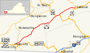
State Route 71 (SR 71) is a primary state highway in the southwest part of the U.S. state of Virginia. It runs from Gate City northeast to Lebanon, mostly through river valleys. Despite running more east–west than north–south, it is signed north–south; it parallels the similarly-oriented U.S. Route 11 and Interstate 81.
Route description
SR 71 begins in Gate City, Scott County where U.S. Routes 23/58/421 Business leaves Jackson Street to head southeast through Moccasin Gap. It runs in a general east-northeasterly direction, soon joining Big Moccasin Creek. The road and creek run through the Moccasin Valley past Slabtown (where SR 72 begins) to Snowflake, where SR 71 leaves the creek to cross Moccasin Ridge. SR 71 leaves the ridge at Dorton Fort and enters the valley formed by Copper Creek, running past Nickelsville.[3]
SR 71 continues in Russell County in a general east-northeasterly direction past Grassy Creek to U.S. Route 58 Alternate at Parsonage. The routes overlap to Dickensonville, where SR 71 splits, continuing to follow Copper Creek to near its source, passing over a small summit, and then following small creeks to its end at US 19 Bus. in Lebanon.[3]
History
Most of present SR 71, from SR 11 (now US 58 Alt.) at Parsonage southwest to about five miles (8.0 km) from Gate City, was added to the state highway system in 1928 as SR 107;[4] the final five miles (8.0 km) were added the next year.[5] In the 1933 renumbering, SR 107 was renumbered SR 71 and extended east from Parsonage along former SR 11 (renumbered SR 64 then) to Dickensonville, replacing the former SR 110 from there to US 19 at Hansonville.[6] As part of the 1940 renumbering, which coordinated numbers with adjacent states, SR 64 and SR 71 were swapped east of Dickensonville, giving SR 71 its present terminus at Lebanon.[7]
Major intersections
| County | Location | mi[8] | km | Destinations | Notes |
|---|---|---|---|---|---|
| Scott | Gate City | 0.00 | 0.00 | ||
| Southern terminus of SR 72 | |||||
| | to former SR 74 east | ||||
| | former SR 72 north | ||||
| Russell | Parsonage | 25.61 | 41.22 | Southern end of US 58 Alt. concurrency | |
| Dickensonville | 27.07 | 43.56 | Northern end of US 58 Alt. concurrency | ||
| Lebanon | 35.82 | 57.65 | |||
1.000 mi = 1.609 km; 1.000 km = 0.621 mi
| |||||
References
- ↑ "2005 Virginia Department of Transportation Jurisdiction Report - Daily Traffic Volume Estimates - Scott County" (PDF). (269 KB)
- ↑ "2005 Virginia Department of Transportation Jurisdiction Report - Daily Traffic Volume Estimates - Russell County" (PDF). (233 KB)
- 1 2 Google (August 5, 2014). "Virginia State Route 71" (Map). Google Maps. Google. Retrieved August 5, 2014.
- ↑ State Highway Commission of Virginia (August 9–10, 1928). Minutes of Meeting (PDF) (Report). Richmond, VA: Commonwealth of Virginia., page 12
- ↑ State Highway Commission of Virginia (August 15, 1929). Minutes of Meeting (PDF) (Report). Richmond, VA: Commonwealth of Virginia., page 15
- ↑ Virginia Highways Project: VA 71
- ↑ State Highway Commission of Virginia (October 10, 1940). Minutes of Meeting (PDF) (Report). Richmond, VA: Commonwealth of Virginia., page 12
- ↑ "VDOT Annual Average Daily Traffic (AADT)" (Shapefile). Virginia Department of Transportation. 2012. Retrieved May 17, 2014.
External links
Virginia Highways Project: VA 71
| < SR 106 | District 1 State Routes 1928–1933 |
SR 108 > |