Venango, Kansas
| Venango, Kansas | |
|---|---|
| Unincorporated community | |
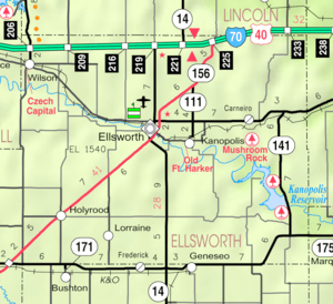 KDOT map of Ellsworth County (legend) | |
 Venango  Venango | |
| Coordinates: 38°38′20″N 97°59′11″W / 38.63889°N 97.98639°WCoordinates: 38°38′20″N 97°59′11″W / 38.63889°N 97.98639°W[1] | |
| Country | United States |
| State | Kansas |
| County | Ellsworth |
| Elevation[1] | 1,516 ft (462 m) |
| Time zone | CST (UTC-6) |
| • Summer (DST) | CDT (UTC-5) |
| Area code | 785 |
| FIPS code | 20-73465 [1] |
| GNIS ID | 476930 [1] |
Venango is an unincorporated community in Ellsworth County, Kansas, United States. It is located on the east bank of the Kanopolis Lake.
History
A post office was opened in Venango in 1875, and remained in operation until it was discontinued in 1902.[2]
See also
- Kanopolis Lake
- Kanopolis State Park
- Mushroom Rock State Park
- Yankee Run, Kansas, located on west bank of Kanopolis Lake
References
- 1 2 3 4 Geographic Names Information System (GNIS) details for Venango, Kansas; United States Geological Survey (USGS); October 13, 1978.
- ↑ "Kansas Post Offices, 1828-1961 (archived)". Kansas Historical Society. Archived from the original on October 9, 2013. Retrieved 9 June 2014.
External links
Municipalities and communities of Ellsworth County, Kansas, United States | ||
|---|---|---|
| Cities |  | |
| Unincorporated communities | ||
| Ghost towns | ||
| Townships | ||
This article is issued from Wikipedia - version of the 8/23/2016. The text is available under the Creative Commons Attribution/Share Alike but additional terms may apply for the media files.