Kanopolis, Kansas
| Kanopolis, Kansas | |
|---|---|
| City | |
 Location within County and Kansas | |
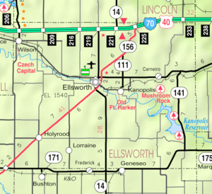 KDOT map of Ellsworth County (legend) | |
| Coordinates: 38°42′35″N 98°9′25″W / 38.70972°N 98.15694°WCoordinates: 38°42′35″N 98°9′25″W / 38.70972°N 98.15694°W | |
| Country | United States |
| State | Kansas |
| County | Ellsworth |
| Government | |
| • Type | Mayor–Council |
| • Mayor | Cherie Sauers[1] |
| • City Clerk | Yvonne Stoppel[1] |
| Area[2] | |
| • Total | 1.20 sq mi (3.11 km2) |
| • Land | 1.20 sq mi (3.11 km2) |
| • Water | 0 sq mi (0 km2) |
| Elevation | 1,585 ft (483 m) |
| Population (2010)[3] | |
| • Total | 492 |
| • Estimate (2015)[4] | 474 |
| • Density | 410/sq mi (160/km2) |
| Time zone | Central (CST) (UTC-6) |
| • Summer (DST) | CDT (UTC-5) |
| ZIP code | 67454 |
| Area code | 785 |
| FIPS code | 20-35950 [5] |
| GNIS feature ID | 0475464 [6] |
| Website | City Website |
Kanopolis is a city in Ellsworth County, Kansas, United States. As of the 2010 census, the city population was 492.[7] The town is built on the site of Fort Harker, a United States Army post that housed infantry and cavalry troops involved in the Indian Wars from 1867 to 1872.
History
Pre-Kanopolis
Fort Ellsworth was the first frontier fort established in the Kanopolis area.[8] It was built by the United States Army in August, 1864 at the junction of the Fort Riley-Fort Larned Road and the Smoky Hill Trail, near the Smoky Hill River.[9] Its purpose was to protect construction of the Union Pacific railroad from Native American raids.[9] In November, 1866 Fort Ellsworth changed its name to Fort Harker after the death of General G.H. Charles Harker, who was killed in battle in 1864.[9]
By this time, the fort had grown in importance as a military staging post and supply depot for forts further west, and needed to expand to continue meeting its mission. As a result, on November 17, 1866, the Army ordered the construction of a new fort approximately three-quarters mile east of the current location.[9] The original Fort Ellsworth was closed in early 1867, and the town of Ellsworth was founded in its place.[9]
In January 1867, Fort Harker was relocated approximately three-quarters mile east of the old location to an open prairie about one mile north of the Smoky Hill river.[9] This new location featured a "large, well-equipped" hospital," which housed those were ill.[9] The hospital was surely busy, as about 200 people died in 1867 from cholera in and around the Fort Harker area. <[9] For the next five years, Fort Harker became one of the most important military stations west of the Missouri River.[cite the Guardhouse national register nomination] It used 700 soldiers and twice as many civilian employees, as well as 400 horses and mules. Additionally, the mail to all military posts down the Arkansas river, as well as many posts in Colorado and New Mexico, was supplied from Fort Harker.[9]
Over the coming years, the threat of Native American raids in the region diminished as territory was secured and railroad construction moved west. No longer of geographic significance, Fort Harker was abandoned on April 2, 1872 [8] and the war department ordered it to be closed shortly thereafter.[10] Its garrison was relocated to Fort Hays.[11] In the winter of 1872-1873, Fort Harker briefly stationed troops once more [8][12] before being deserted one final time. In the following years, Fort Harker became the Fort Harker Military Reservation.
Kanopolis begins
In June of 1880, the Senate passed bill S.194, an act disposing Fort Harker Military Reservation of public ownership and giving the 10,240 acre tract of land to the Interior Department for sale.[8][11] A Dr. Hodge acquired the land and sold it to Col. Henry Johnson for $4,177.50 in August, 1881.[12] In summer of 1885, a seventeen-member group of capitalists based in Ohio led by Ross Mitchell (president), F.M. Bookwalter (vice president), and John H. Thomas (treasurer) purchased 4,740 acres of the land, including Fort Harker and its buildings, for $71,000 from Col. Johnson.[8][12][13] Imagining their newly acquired land would soon become a "Central Metropolis," and a future capitol because of its location,[11] the group became chartered as the Kanopolis Land Company on March 15, 1886, with a capital stock of $500,000.[14] They laid out land for 150,000 people[8][11] and shortly after, the town of Kanopolis was founded.[8]
Optimism and Boosterism
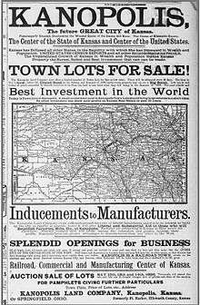
The Kanopolis Land Co., with editor R.V. Morgan, advertised in other newspapers and in a paper of their own called The Kanopolis Journal to attract buyers to Kanopolis.[15] These advertisements serve as examples of the boosterism characteristic of the frontier west. One from May 1886 proclaimed Kanopolis "is destined to be the railroad, commercial, and manufacturing capital of Kansas"[16] and said buying land in Kanopolis is the "Best investment in the world." Another in July 1887 declared it to be the only town in the state with railroads running north, south, east, and west and also claimed to have seven factories, thirteen stores, and a hotel. It reported the population to be 600 when the town was "scarcely" one year old.[13]
More hyperbolic than the advertisements in other newspapers was The Kanopolis Journal. It boasted Kanopolis to have "woolen mills, iron factories, carriage works, flour mills, wholesale houses, banks, a drug store, and an opera house, doctors, and machine shops," as well as a brewery.[15] Additionally, the journal predicts Kanopolis would soon be the furniture hub of the midwest, saying it "is not one-half the distance from a limitless supply of walnut, oak, ash, poplar and all lumber needed in the manufacture of furniture as is Grand Rapids, Michigan, which owes its prosperity to the furniture business."[15] It said that in forty years it will have 500,000 inhabitants, as it had already "grown as populous as Cincinnati did in eleven years or Cleveland did in thirty years."[15] The journal also describes giant potatoes, cabbage leaves that "are used for circus tents," jack rabbits that "grow as large as horses," and pea pods that "are used as ferry boats on the Arkansas river."[15] It also claims "A man planted a turnip one mile from the railroad last summer and the company sued him for obstructing the track before the middle of July." Additionally, the journal says that "North of Kanopolis are several lakes of strained honey, and we also often have showers of rosewater and cologne in the early spring." [15] The journal even says the area around Kanopolis is the real garden of Eden, and that there is a fig tree that Eve herself used to make her first clothes, and that the tree is "like our flag - it is still there, and furnishes evidence which our oldest inhabitants dare not dispute.... This settlement of Western Kansas is restoring Eden to its primitive glory and men to their first estate."[15]
Shy of Expectations
Kanopolis, for a variety of reasons, never became the "Queen City of the Midwest" that its backers "ballyhooed" it would become.[11] Perhaps its biggest injury was when it lost a referendum by 75 votes to become the seat of Ellsworth county.[11] Also, it had some contemporary antagonists. An editorial in a January, 1887 paper from the Leavenworth Times calls Kanopolis a "buffalo wallow," a "scheme," and a "fraud" from an "eastern syndicate.".[17] A lawsuit between the Kanopolis Land Co. and R.V. Morgan in 1895 ensued, likely detracting from the company's ability to advertise and sell land.[18] By 1906, Kanopolis' population had fallen to 264.[15]
Geography
Kanopolis is located at 38°42′35″N 98°9′25″W / 38.70972°N 98.15694°W (38.709707, -98.157020).[19] According to the United States Census Bureau, the city has a total area of 1.20 square miles (3.11 km2), all of it land.[2]
Climate
The climate in this area is characterized by hot, humid summers and generally mild to cool winters. According to the Köppen Climate Classification system, Kanopolis has a humid subtropical climate, abbreviated "Cfa" on climate maps.[20]
Demographics
| Historical population | |||
|---|---|---|---|
| Census | Pop. | %± | |
| 1890 | 272 | — | |
| 1900 | 240 | −11.8% | |
| 1910 | 577 | 140.4% | |
| 1920 | 762 | 32.1% | |
| 1930 | 860 | 12.9% | |
| 1940 | 868 | 0.9% | |
| 1950 | 743 | −14.4% | |
| 1960 | 732 | −1.5% | |
| 1970 | 626 | −14.5% | |
| 1980 | 729 | 16.5% | |
| 1990 | 605 | −17.0% | |
| 2000 | 543 | −10.2% | |
| 2010 | 492 | −9.4% | |
| Est. 2015 | 474 | [4] | −3.7% |
| U.S. Decennial Census | |||
2010 census
As of the census[3] of 2010, there were 492 people, 235 households, and 151 families residing in the city. The population density was 410.0 inhabitants per square mile (158.3/km2). There were 273 housing units at an average density of 227.5 per square mile (87.8/km2). The racial makeup of the city was 94.5% White, 1.2% Native American, 0.6% from other races, and 3.7% from two or more races. Hispanic or Latino of any race were 10.4% of the population.
There were 235 households of which 20.4% had children under the age of 18 living with them, 50.6% were married couples living together, 7.2% had a female householder with no husband present, 6.4% had a male householder with no wife present, and 35.7% were non-families. 34.0% of all households were made up of individuals and 15.4% had someone living alone who was 65 years of age or older. The average household size was 2.09 and the average family size was 2.58.
The median age in the city was 48.7 years. 16.7% of residents were under the age of 18; 7.8% were between the ages of 18 and 24; 19.9% were from 25 to 44; 34.8% were from 45 to 64; and 20.7% were 65 years of age or older. The gender makeup of the city was 51.8% male and 48.2% female.
2000 census
As of the census[5] of 2000, there were 543 people, 248 households, and 153 families residing in the city. The population density was 453.7 people per square mile (174.7/km²). There were 295 housing units at an average density of 246.5 per square mile (94.9/km²). The racial makeup of the city was 85.21% White, 0.37% African American, 0.18% Asian, 2.76% from other races, and 1.47% from two or more races. Hispanic or Latino of any race were 12.71% of the population.
There were 248 households out of which 25.4% had children under the age of 18 living with them, 49.2% were married couples living together, 9.3% had a female householder with no husband present, and 38.3% were non-families. 34.3% of all households were made up of individuals and 18.1% had someone living alone who was 65 years of age or older. The average household size was 2.19 and the average family size was 2.80.
In the city the population was spread out with 22.1% under the age of 18, 6.3% from 18 to 24, 23.8% from 25 to 44, 25.2% from 45 to 64, and 22.7% who were 65 years of age or older. The median age was 44 years. For every 100 females there were 96.0 males. For every 100 females age 18 and over, there were 90.5 males.
As of 2000 the median income for a household in the city was $31,413, and the median income for a family was $39,531. Males had a median income of $30,170 versus $21,250 for females. The per capita income for the city was $16,161. About 4.6% of families and 6.9% of the population were below the poverty line, including 1.7% of those under age 18 and 12.8% of those age 65 or over.
Government
The Kanopolis government consists of a mayor and five council members. The council meets the 2nd Tuesday of each month at 7PM.[1]
- City Hall, 119 N Kansas.
See also
References
- 1 2 3 "Kanopolis - Directory of Kansas Public Officials". lkm.org.
- 1 2 "US Gazetteer files 2010". United States Census Bureau. Retrieved 2012-07-06.
- 1 2 "American FactFinder". United States Census Bureau. Retrieved 2012-07-06.
- 1 2 "Annual Estimates of the Resident Population for Incorporated Places: April 1, 2010 to July 1, 2015". Retrieved July 2, 2016.
- 1 2 "American FactFinder". United States Census Bureau. Retrieved 2008-01-31.
- ↑ "US Board on Geographic Names". United States Geological Survey. 2007-10-25. Retrieved 2008-01-31.
- ↑ "2010 City Population and Housing Occupancy Status". U.S. Census Bureau. Retrieved April 6, 2011.
- 1 2 3 4 5 6 Vaughn, Carlene. "Fort Ellsworth/Fort Harker Timeline." Kansas State Historical Society. June 27, 1997. Accessed April 28, 2015. https://www.kshs.org/kansapedia/fort-ellsworth-fort-harker-timeline/11178.
- 1 2 3 4 5 6 7 8 9 National Register of Historic Places, Fort Harker Officers' Quarters, Kanopolis, Ellsworth County, Kansas
- ↑ Walnut Valley Times, June 14, 1872. Accessed April 28, 2015. https://www.newspapers.com/image/95410593/?terms=walnut%2Bvalley%2Btimes%2Bfort%2Bharker
- 1 2 3 4 5 6 Gaston, Pat. "Kanopolis-Fort Harker Area Wanted to Be Capitol Site." The Salina Journal, September 14, 1975. Accessed April 28, 2015. https://www.newspapers.com/image/43942536/?terms=kanopolis+fort+harker+capitol+site+gaston.
- 1 2 3 National Register of Historic Places, Fort Harker Guardhouse, Kanopolis, Ellsworth County, Kansas.
- 1 2 Crowell, J.S. "Kanopolis." Frankfort Roundabout, July 9, 1887. Accessed April 28, 2015. https://www.newspapers.com/image/68053572/?terms=kanopolis+july+frankfort+roundabout.
- ↑ Topeka Daily Capital, March 16, 1886. Accessed April 28, 2015. https://www.newspapers.com/image/64234859/?terms=kanopolis%2Bland%2Bco
- 1 2 3 4 5 6 7 8 "Tragedy of a Town." The Salina Journal, February 26, 1906. Accessed April 28, 2015. https://www.newspapers.com/image/92718751/?terms=%22tragedy%2Bof%2Ba%2Btown%22%2Bkanopolis
- ↑ "Kanopolis, the Future Great City of Kansas." Lawrence Daily Journal. May 13, 1886. Accessed April 28, 2015.https://www.newspapers.com/image/59640967/?terms=kanopolis%2Bmanufacturing%2Brailroad%2Bcommercial%2Bcenter%2Bof%2Bkansas
- ↑ Leavenworth Times. January 30, 1887. Accessed April 28, 2015.https://www.newspapers.com/image/78332330/?terms=kanopolis%2Bbuffalo%2Bwallow%2Bmcpherson
- ↑ Topeka Daily Capital. July 7, 1895. Accessed April 28, 2015. https://www.newspapers.com/image/65353436/?terms=topeka%2Bdaily%2BR.V.%2BMorgan%2Bkanopolis
- ↑ "US Gazetteer files: 2010, 2000, and 1990". United States Census Bureau. 2011-02-12. Retrieved 2011-04-23.
- ↑ "Kanopolis, Kansas Köppen Climate Classification (Weatherbase)". Weatherbase.
External links
| Wikimedia Commons has media related to Kanopolis, Kansas. |
- City
- Schools
- USD 327, local school district
- Maps
- Kanopolis City Map, KDOT
Municipalities and communities of Ellsworth County, Kansas, United States | ||
|---|---|---|
| Cities | 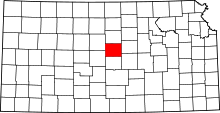 | |
| Unincorporated communities | ||
| Ghost towns | ||
| Townships | ||