Carneiro, Kansas
| Carneiro, Kansas | |
|---|---|
| Unincorporated community | |
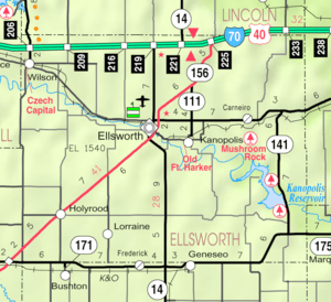 KDOT map of Ellsworth County (legend) | |
 Carneiro  Carneiro | |
| Coordinates: 38°44′20″N 98°01′51″W / 38.73889°N 98.03083°WCoordinates: 38°44′20″N 98°01′51″W / 38.73889°N 98.03083°W[1] | |
| Country | United States |
| State | Kansas |
| County | Ellsworth |
| Township | Carneiro |
| Elevation[1] | 1,578 ft (481 m) |
| Time zone | CST (UTC-6) |
| • Summer (DST) | CDT (UTC-5) |
| Area code | 785 |
| FIPS code | 20-10775 [1] |
| GNIS ID | 475476 [1] |
Carneiro is an unincorporated community in Ellsworth County, Kansas, United States.[2] It is located approximately 10 miles (16 km) east of Ellsworth.
History
Carneiro was a station and shipping point on the Union Pacific Railroad.[3]
The first post office in Carneiro was established as Alum Creek in 1872. The post office was renamed Carneiro in 1882, and remained in operation until it was discontinued in 1953.The obituary of Ernest Oakley Cunningham states that he served as Post Master in Carneiro, then later, Post Master in Langley, Kansas. Mr. Cunningham came to Ellsworth county in 1870, at the age of 15. At the time of his death, he was the oldest of the pioneers then living in Ellsworth County.[4][5]
See also
References
- 1 2 3 4 Geographic Names Information System (GNIS) details for Carneiro, Kansas; United States Geological Survey (USGS); October 13, 1978.
- ↑ "Carneiro, Kansas". Geographic Names Information System. United States Geological Survey.
- ↑ Blackmar, Frank Wilson (1912). Kansas: A Cyclopedia of State History, Embracing Events, Institutions, Industries, Counties, Cities, Towns, Prominent Persons, Etc. Standard Publishing Company. p. 288.
- ↑ Obituary, Ellsworth KS, Ellsworth Messenger, Thursday, December 14, 1939
- ↑ "Kansas Post Offices, 1828-1961 (archived)". Kansas Historical Society. Archived from the original on October 9, 2013. Retrieved 9 June 2014.
External links
Municipalities and communities of Ellsworth County, Kansas, United States | ||
|---|---|---|
| Cities | 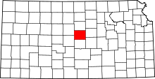 | |
| Unincorporated communities | ||
| Ghost towns | ||
| Townships | ||
This article is issued from Wikipedia - version of the 11/2/2016. The text is available under the Creative Commons Attribution/Share Alike but additional terms may apply for the media files.