Empire Township, Ellsworth County, Kansas
| Empire Township | |
|---|---|
| Township | |
 Location in Ellsworth County | |
| Coordinates: 38°39′12″N 098°02′09″W / 38.65333°N 98.03583°WCoordinates: 38°39′12″N 098°02′09″W / 38.65333°N 98.03583°W | |
| Country | United States |
| State | Kansas |
| County | Ellsworth |
| Area | |
| • Total | 71.81 sq mi (185.98 km2) |
| • Land | 66.21 sq mi (171.49 km2) |
| • Water | 5.59 sq mi (14.49 km2) 7.79% |
| Elevation | 1,506 ft (459 m) |
| Population (2000) | |
| • Total | 174 |
| • Density | 2.6/sq mi (1/km2) |
| GNIS feature ID | 0475469 |
Empire Township is a township in Ellsworth County, Kansas, USA. As of the 2000 census, its population was 174.
Geography
Empire Township covers an area of 71.81 square miles (186.0 km2) and contains no incorporated settlements. According to the USGS, it contains two cemeteries: Buckeye and Scates.
The streams of Alum Creek, Bluff Creek, Clear Creek, Sand Creek, Skunk Creek and Thompson Creek run through this township.
Transportation
Empire Township contains one airport or landing strip, Kanopolis State Park Airport.
References
External links
Municipalities and communities of Ellsworth County, Kansas, United States | ||
|---|---|---|
| Cities | 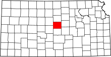 | |
| Unincorporated communities | ||
| Ghost towns | ||
| Townships | ||
This article is issued from Wikipedia - version of the 11/11/2013. The text is available under the Creative Commons Attribution/Share Alike but additional terms may apply for the media files.