Vandergrift Historic District
|
Vandergrift Historic District | |
|
Washington Avenue in Vandergrift, HABS photo, April 1990 | |
  | |
| Location | Roughly bounded by Lincoln, Sherman, Franklin and Washington Aves., along the outer lot lines, Vandergrift, Pennsylvania |
|---|---|
| Coordinates | 40°36′09″N 79°33′44″W / 40.60250°N 79.56222°WCoordinates: 40°36′09″N 79°33′44″W / 40.60250°N 79.56222°W |
| Area | 88 acres (36 ha) |
| Built | 1895 |
| Architect | Olmsted, Frederick Law, Firm |
| Architectural style | Queen Anne, Romanesque, Colonial Revival |
| NRHP Reference # | 95000525[1] |
| Added to NRHP | April 27, 1995 |
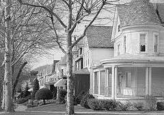
Vandergrift Historic District is a national historic district located at Vandergrift, Westmoreland County, Pennsylvania. It encompasses 625 contributing buildings and 2 contributing sites in Vandergrift. They were built between about 1895 and 1925, and includes a mix of residential, commercial, and institutional properties. They are in a variety of popular architectural styles including Romanesque, Queen Anne, and Colonial Revival, and laid out on a plan developed by Frederick Law Olmsted. Notable non-residential buildings include the Casino, train station, company office building, and churches. The two contributing sites are landscaped parks.[2]
It was added to the National Register of Historic Places in 1995.[1]
References
- 1 2 National Park Service (2010-07-09). "National Register Information System". National Register of Historic Places. National Park Service.
- ↑ "National Historic Landmarks & National Register of Historic Places in Pennsylvania" (Searchable database). CRGIS: Cultural Resources Geographic Information System. Note: This includes Terry A. Necciai (January 1995). "National Register of Historic Places Inventory Nomination Form: Vandergrift Historic District" (PDF). Retrieved 2012-06-16.
External links
- Historic American Engineering Record (HAER) No. PA-250, "Vandergrift Railroad Station, 77 Washington Avenue, Vandergrift, Westmoreland County, PA", 1 photo, 3 data pages, 1 photo caption page
- HAER No. PA-296, "Apollo Iron & Steel Works, West of Washington & Lincoln Avenues, Vandergrift, Westmoreland County, PA", 4 photos, 1 color transparency, 4 data pages, 2 photo caption pages
- HAER No. PA-296-A, "Apollo Iron & Steel Works, Company Housing", 3 photos, 3 data pages, 1 photo caption page
| Topics |   | |
|---|---|---|
| Lists by county |
| |
| Lists by city | ||
| Other lists | ||
| ||
This article is issued from Wikipedia - version of the 11/29/2016. The text is available under the Creative Commons Attribution/Share Alike but additional terms may apply for the media files.