Upson, Wisconsin
| Upson, Wisconsin | |
|---|---|
| Unincorporated community | |
|
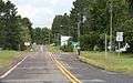
Looking east in Upson on WIS77 | |
 Upson, Wisconsin  Upson, Wisconsin | |
| Coordinates: 46°22′09″N 90°24′25″W / 46.36917°N 90.40694°WCoordinates: 46°22′09″N 90°24′25″W / 46.36917°N 90.40694°W | |
| Country | United States |
| State | Wisconsin |
| County | Iron |
| Elevation | 1,489 ft (454 m) |
| Time zone | Central (CST) (UTC-6) |
| • Summer (DST) | CDT (UTC-5) |
| ZIP code | 54565[1] |
| Area code(s) | 715 & 534 |
| GNIS feature ID | 1576004[2] |

Upson is an unincorporated community located in Iron County, Wisconsin, United States. Upson is located at the junction of Wisconsin Highway 77 and Wisconsin Highway 122 12 miles (19 km) southwest of Hurley, in the town of Anderson. Upson had an Air Defense Command radar station of the Permanent System radar network (P-16B, 46°25′10″N 090°23′06″W / 46.41944°N 90.38500°W) and a post office, which closed on March 16, 1985.[3]
Images
 Looking north at Upson from southern terminus of WIS122
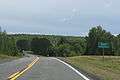 Looking east at the sign for Upson on WIS77
 Looking west at the sign for Upson on WIS77
References
| Wikimedia Commons has media related to Upson, Wisconsin. |
- ↑ United States Postal Service (2012). "USPS - Look Up a ZIP Code". Retrieved 2012-02-15.
- ↑ U.S. Geological Survey Geographic Names Information System: Upson, Wisconsin
- ↑ "Postmaster Finder - Post Offices by ZIP Code". United States Postal Service. Retrieved September 25, 2011.
Municipalities and communities of Iron County, Wisconsin, United States | ||
|---|---|---|
| Cities | 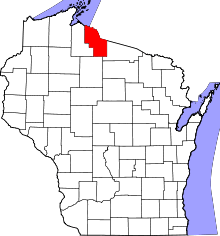 | |
| Towns | ||
| CDPs | ||
| Unincorporated communities | ||
| Indian reservations | ||
| Footnotes | ‡This populated place also has portions in an adjacent county or counties | |
This article is issued from Wikipedia - version of the 7/29/2016. The text is available under the Creative Commons Attribution/Share Alike but additional terms may apply for the media files.