Manitowish, Wisconsin
For Manitowish Waters, see Manitowish Waters, Wisconsin.
| Manitowish, Wisconsin | |
|---|---|
| Unincorporated community | |
|
Intersection of US51 and WIS182/WIS47 | |
 Manitowish, Wisconsin  Manitowish, Wisconsin | |
| Coordinates: 46°07′59″N 90°00′49″W / 46.13306°N 90.01361°W | |
| Country | United States |
| State | Wisconsin |
| County | Iron |
| Elevation | 1,591 ft (485 m) |
| Time zone | Central (CST) (UTC-6) |
| • Summer (DST) | CDT (UTC-5) |
| Area code(s) | 715 & 534 |
| GNIS feature ID | 1568939[1] |

Manitowish is an unincorporated community located within the Town of Mercer, Iron County Wisconsin.[1] It is located at the junction of U.S. Route 51, Wisconsin Highway 47 and Wisconsin Highway 182.[2]
History
A post office called Manitowish was established in 1890, and remained in operation until it was discontinued in 1968.[3] The community took its name from the nearby Manitowish River.[4]
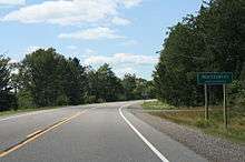
Sign for Manitowish
Notes
- 1 2 "Manitowish". Geographic Names Information System. United States Geological Survey.
- ↑ Iron County (PDF) (Map). Wisconsin Department of Transportation. Retrieved 2011-05-25.
- ↑ "Iron County". Jim Forte Postal History. Retrieved 22 March 2015.
- ↑ Chicago and North Western Railway Company (1908). A History of the Origin of the Place Names Connected with the Chicago & North Western and Chicago, St. Paul, Minneapolis & Omaha Railways. p. 97.
Coordinates: 46°07′59″N 90°00′49″W / 46.13306°N 90.01361°W
Municipalities and communities of Iron County, Wisconsin, United States | ||
|---|---|---|
| Cities | 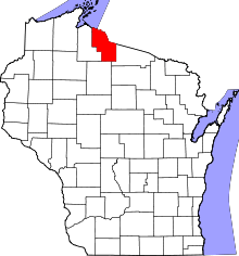 | |
| Towns | ||
| CDPs | ||
| Unincorporated communities | ||
| Indian reservations | ||
| Footnotes | ‡This populated place also has portions in an adjacent county or counties | |
This article is issued from Wikipedia - version of the 10/23/2016. The text is available under the Creative Commons Attribution/Share Alike but additional terms may apply for the media files.