Upper Halliford
| Upper Halliford | |
 Upper Halliford Green |
|
 St Andrew's Baptist Church |
|
 Upper Halliford |
|
| Area | 2.20 km2 (0.85 sq mi) |
|---|---|
| Population | 3,173 (2011 census)[1] |
| – density | 1,442/km2 (3,730/sq mi) |
| OS grid reference | TQ0968 |
| – London | 15.6 miles (25.1 km) |
| District | Spelthorne |
| Shire county | Surrey |
| Region | South East |
| Country | England |
| Sovereign state | United Kingdom |
| Post town | Shepperton |
| Postcode district | TW17 |
| Dialling code | 01932 |
| Police | Surrey |
| Fire | Surrey |
| Ambulance | South East Coast |
| EU Parliament | South East England |
| UK Parliament | Spelthorne |
Coordinates: 51°24′04″N 0°25′52″W / 51.401°N 0.431°W
Upper Halliford is a small linear village, part of the Shepperton post town, in the borough of Spelthorne, Surrey, England within the Metropolitan Green Belt. Its railway station is on the northern boundary and by part of Sunbury on Thames (which remains its Anglican parish) on a branch line from London; the M3 is just beyond. Upper Halliford is within the circle of the M25. Its closest settlements are Shepperton, Charlton and Walton on Thames.
The village is partially on and partially by the A244 which alternates here between a dual carriageway and a single carriageway. All of the settled area is however on or beside a single carriageway as the corollary dual carriageway section takes through traffic around the south, village green part of the settlement. Part of this brief dual section has been harmonised to one lane, and Walton Bridge to the south along with almost all of the route is not dualled. No high rise buildings are in the village. Mid-rise flats are near to the village green and it has a conservation area.
History
Etymology
Halliford derives from a ford on the River Ash where a holy man lived during Anglo-Saxon times and performed miracles; the name Holy Ford eventually evolved into Halliford.[2]
Early history
Throughout its early history Halliford Manor's land was divided; in the Sunbury Charter of 962 AD the Anglo-Saxons fixed Sunbury on Thames's parish boundaries along the River Ash and then far to the west, by a north-south stream/ditch by the Queen Mary Reservoir (built 1925–31).[3] However a Halliford Manor House and demesne are recorded as being in Shepperton where two contenders to the original medieval house exist near the River Thames. Upper Halliford was always part of the parish of Sunbury on Thames, in which its modern manor, Halliford Manor leaves a trace, centred immediately north-east of the village centre. Charlton is mentioned by the Domesday Book of 1086 and Halliford in 962, though no reference has been found to the hamlet of Upper Halliford before 1274.[3] In terms of the feudal system, Upper Halliford was in the wider Spelthorne Hundred until hundreds became redundant with the formation of rural districts and urban district councils and until 1 April 1965 was in the now historic and ceremonial county of Middlesex[4]
In the 14th century a windmill stood at Upper Halliford, later to be replaced by a windmill at Lower Halliford (now generally considered part of Shepperton).[2]
Kempton, Sunbury, Halliford and later Upper Halliford all formed the nucleus of a medieval manor, except for Upper Halliford which was probably the lesser of the two Halliford hamlets within Halliford manor formed a narrow strip running back from the River Thames over the open fields to the common land [n 1] to the north. Also a common meadow lay by the river in the south and southeast of Upper Halliford.[3]
Upper Halliford Road and Windmill Road gained in importance after Walton Bridge was built in 1750. Gaston Bridge over the Ash in Upper Halliford, which had been in existence at least since the 15th century, was rebuilt at the same time.[3]
Upper Halliford and Charlton did not share in the 18th-century popularity of the riverside and contained little but cottages and farmhouses. Several houses around the green at Upper Halliford survive from the early 19th century, while those called Halliford Manor and Home Farm Cottage close to the green are earlier; in the case of Halliford Manor its clock in its adjoining Clock House Cottage is dated 1744,[5] though they have been much altered.[3]
Post Industrial Revolution
Based on 1841 census statistics, Samuel Lewis (publisher) in his 1848 A topographical guide to England stated the population of the parish of Sunbury which included Charlton and Upper Halliford, an area of 2,580 acres (1,040 ha) was 1,828. [n 2]
On the establishment of the postal system, the post town of Shepperton was chosen for Upper Halliford, which is from the perspective of the southern half is geographically closer than Sunbury-on-Thames.[7]
In 1894 the urban district of Sunbury on Thames was founded, comprising just the parish of Sunbury on Thames including, as the ecclesiastical parish does,[8] Upper Halliford and at that time also included Charlton.[3]
A halt at Upper Halliford along the Victorian railway to Shepperton was not opened until 1944, to serve the factories of the Sunbury Industrial Estate in World War II and was still a halt until at least 1962.[3]
Until the 1950s there was very little new building in the western half of Sunbury parish. Gravel-working had left many large pools around Upper Halliford and Charlton, and the rest of the land was open, with many market-gardens and glasshouses. A good deal of land still remained open in 1959 and gravel-working was continuing, but there was new building around Upper Halliford
Geography
Surrounded on all sides by a Green Buffer, Upper Halliford is situated 15.6 miles (25.1 km) southwest of London and 12.3 miles (19.8 km) NNE of the county town, Guildford with easy access to the River Thames 1 mile (1.6 km) to the south and Heathrow Airport centred 4.5 miles (7.2 km) to the north.
A bypass of the A244 cuts off a portion of the west of the village with a pedestrian crossing from meeting minor roads on each side, leaving the core of the village with far less traffic compared to the northern stretch. This stretch is made up of Upper Halliford Road: its west side has a residential estate, nurseries in front of a railway line, whereas its east side has Grange Farm mobile home village, farmhouse, residual farm, Upper Halliford (or Manor Park) recreation ground and nursery before the large road bridge at the border to Sunbury Common, over the Shepperton Branch Line and the M3 motorway.[7]
In 2001 Halliford[n 3] gave a population figure of 3,011.[6]
 |
Charlton | Ashford Common Sunbury Common |
Sunbury on Thames | |
| across Sunbury Golf Course Littleton |
|
Sunbury on Thames | ||
| ||||
| | ||||
| Shepperton | across a farm or across part of Shepperton Walton on Thames |
across two farms and the Swan Sanctuary, Shepperton Walton on Thames |
Elevations, Soil and Geology
Elevations range between 12m AOD which applies for most of the village, with a maximum of 12.4m excluding bridge in the west, to 10.8m AOD in the residential road closest to one of the River Colne's many distribuaries, the River Ash.[9]
In regards to geology, the former flood plain and river course has shaped the almost flat former and present flood plain landscape from just north Heathrow Airport, as far west as Windsor, Berkshire to Brentford, Greater London with free draining alluvium and organic deposits forming a wide area of soil including Spelthorne, underlaid deeper with a mixture of gravel aquifers and London Clay which gives rise to two types of soil of free and poor drainage across all of the lower-lying parts of the London Basin.[10]
Soil across Spelthorne is categorised as "free draining slightly acid and loamy".[11]
Landmarks

Upper Halliford Green and the Upper Halliford Conservation Area
Much of the bypassed Upper Halliford Road area including the main section of its green is a conservation area.[12] This has recognised since 1993 the large number of buildings and structures pre-dating 1900 and the historic road pattern centred on the village green.[2] In this area are seven buildings dating to before 1800.[2] Frith Cottage, the listed building north of The Goat[2] gains its name from former resident, painter William Powell Frith FRA who lived there for a time.
Care Home
A large residential care home was opened next to The Goat in the early part of the 21st century.
Amenities
Garden Centre
The village has a large garden centre with rose nursery, restaurant and café, deli food hall and craft department, rebuilt in a glass design in 2011, Squires,[13]
The Goat
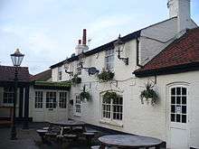
The Goat is a pre-1800 built public house that is the only public house (as well as carvery and other restaurant) in the village centre.[14]
Shopping parade
A convenience shopping parade provides services including a small post office, hairdressers, a café and dry cleaning.
Other
The Baptist church pictured above, opposite the green is also within the bypassed section of main through road and near the flats and shops at the centre of the village. Another pub once known as The Bugle is beside the combined single carriageway to the north and by the village park below.
Sport and park
A large recreation ground co-exists with Halliford Park to the north of the main village and is close to Grange Farm Estate, a neatly laid-out mobile home estate,[7] which has football, flowers, trees and paths.
Demography and housing
| Output area | Detached | Semi-detached | Terraced | Flats and apartments | Caravans/temporary/mobile homes | Shared between households[1] |
|---|---|---|---|---|---|---|
| Spelthorne 011A[n 4] | 53 | 161 | 281 | 94 | 141 | 0 |
| Spelthorne 011C[n 5] | 182 | 222 | 101 | 88 | 26 | 0 |
The average level of accommodation in the region composed of detached houses was 28%, the average that was apartments was 22.6%.
| Output area | Population | Households | % Owned outright | % Owned with a loan | hectares[1] |
|---|---|---|---|---|---|
| Spelthorne 011A | 1,599 | 730 | 43.6 | 34.7 | 92 |
| Spelthorne 011C | 1,574 | 619 | 38.8 | 37.5 | 128 |
Transport
- Road
Junction 1 of the M3 motorway is 1.2 miles (1.9 km) northeast along a choice of routes and the M25 motorway is a few mile further along that motorway at Junction 2 "the Chertsey Interchange".
- Rail
Upper Halliford railway station provides a half-hourly service to London Waterloo station for which the journey time is 47–52 minutes[15] and to Shepperton. Walton on Thames railway station has more frequent services easily accessible by bus from the south of the village which provides the South West Main Line and a 20 minute service to London Waterloo station. In both cases there is only one train service provider, South West Trains.
- Bus
- The 555 bus services from/to Heathrow Airport passes the south of the conservation area of the village via Halliford Road and Gaston Bridge Road linking to Walton-on-Thames railway station.
- The 557 bus service from/to Heathrow Airport follows the same route until Shepperton however continues instead to Woking via St Peter's Hospital and Chertsey.
References
- Notes
- ↑ See Ashford Common/Sunbury Common
- ↑ The area of Upper Halliford is 220.08 hectares (543.8 acres) according to areas 11A and 11C of the 2001 Census[6]
- ↑ Upper Halliford consists of Spelthorne 11A and 11C Lower Layer Super Output Areas
- ↑ Upper Halliford North
- ↑ Upper Halliford South
- References
- 1 2 3 Key Statistics; Quick Statistics: Population Density United Kingdom Census 2011 Office for National Statistics Hallford forms half of a ward. To date it has been grouped, as historically with parts of Sunbury-on-Thames
- 1 2 3 4 5 Conservation Area Appraisal Document
- 1 2 3 4 5 6 7 Susan Reynolds (Editor) (1962). "Sunbury: Introduction". A History of the County of Middlesex: Volume 3: Shepperton, Staines, Stanwell, Sunbury, Teddington, Heston and Isleworth, Twickenham, Cowley, Cranford, West Drayton, Greenford, Hanwell, Harefield and Harlington. Institute of Historical Research. Retrieved 10 November 2012.
- ↑ London Government Act 1963 effective date: 1 April 1965
- ↑ Halliford Manor
- 1 2 Census data
- 1 2 3 Grid reference Finder measurement tools
- ↑ The Church of England — St Mary's, Sunbury-on-Thames
- ↑ Ordnance Survey map, courtesy of English Heritage
- ↑ Natural England – Geodiversity
- ↑ Cranfield University National Soil Resources Institute
- ↑ Upper Halliford Conservation Area — Map
- ↑ Squires — Shepperton Garden Centre
- ↑ English Heritage Listed Buildings Register
- ↑ Association of Train Operating Companies – official timetable
External links
| Wikimedia Commons has media related to Upper Halliford. |
| Towns, villages and localities | 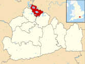 | ||||||||||
|---|---|---|---|---|---|---|---|---|---|---|---|
| Key parks | |||||||||||
| Large listed buildings |
| ||||||||||
| Education | |||||||||||
| Railway stations | |||||||||||
| Buildings and structures | |||||||||||
| Sport |
| ||||||||||
| Destroyed landmarks | |||||||||||
Surrey Portal | |
| Boroughs or districts | |
| Major settlements |
|
| Topics | |