Mole Valley
| Mole Valley District | |
|---|---|
| Non-metropolitan district | |
|
Leatherhead High Street | |
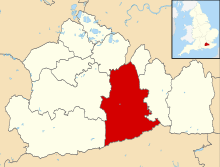 Mole Valley shown within Surrey | |
| Sovereign state | United Kingdom |
| Constituent country | England |
| Region | South East England |
| Non-metropolitan county | Surrey |
| Status | Non-metropolitan district |
| Admin HQ | Dorking |
| Incorporated | 1 April 1974 |
| Government | |
| • Type | Non-metropolitan district council |
| • Body | Mole Valley District Council |
| • Leadership | Alternative - Sec.31 (TBA (council NOC)) |
| • MPs |
Paul Beresford Chris Grayling |
| Area | |
| • Total | 99.7 sq mi (258.3 km2) |
| Area rank |
153rd (of 326) Highest point : Leith Hill |
| Population (mid-2014 est.) | |
| • Total | 86,234 |
| • Rank | 275th (of 326) |
| • Density | 860/sq mi (330/km2) |
| • Ethnicity | 97.4% White |
| Time zone | GMT (UTC0) |
| • Summer (DST) | BST (UTC+1) |
| ONS code |
43UE (ONS) E07000210 (GSS) |
| OS grid reference | TQ0496458567 |
| Website |
www |

Mole Valley is a local government district in Surrey, England. Its council is based in Dorking.
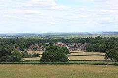
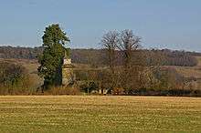
The two towns in the district are Dorking and Leatherhead. The largest villages are Ashtead, Fetcham and Great Bookham, in the northern third of the district. The rest of the district includes some of the Surrey Hills AONB, the middle of the district is dominated by the North Downs, including Polesden Lacey, Box Hill, Denbies Wine Estate (the largest vineyard in the country[1] ) and parts of the Pilgrims' Way, the southern third includes Leith Hill and the Greensand Ridge. There are stations on the London–Worthing and Reading–Gatwick Airport railways, and in the northern third, a commuter stopping service from London–Guildford. Additionally the A24 road and the M25 motorway are the main thoroughfares.
Towns
Other settlements[2]
| Village | Other Settlements | Civil Parish (where applicable) |
|---|---|---|
| Abinger | Abinger Common, Abinger Hammer Forest Green, Walliswood Sutton Abinger and Oakwood Hill[3] |
Abinger |
| Ashtead | ||
| Capel | Beare Green Coldharbour |
Capel |
| Betchworth | Betchworth | |
| Brockham | Strood Green | Brockham |
| Buckland | Buckland | |
| Charlwood | Charlwood | |
| Fetcham | ||
| Great Bookham | ||
| Headley | Box Hill | Headley |
| Holmwood - includes Chart Downs, Goodwyns, North, South and Mid | Holmwood | |
| Leigh | Shellwood Cross Dawesgreen |
Leigh |
| Little Bookham | ||
| Mickleham | Mickleham | |
| Newdigate | Parkgate | Newdigate |
| Ockley | Ockley | |
| Ranmore | ||
| Westcott | ||
| Westhumble | ||
| Wotton | Friday Street | Wotton |
Governance
Mole Valley District Council is elected by thirds: one-third of councillors are elected at each election, each serving four year terms; three years out of four having elections.
The council was however elected across all areas in 2000 after major boundary changes to the wards.
Although Mole Valley (UK Parliament constituency) has been Conservative for a long time, Mole Valley District Council has, with Independent/RA and Liberal Democrats, for long periods been under no overall control.[4]
| First Elected | Conservative | Labour | Lib Dem | Independent | Other | |
|---|---|---|---|---|---|---|
| 1999 | 17 | 1 | 16 | 7 | 0 | |
| 2000 | 19 | 1 | 14 | 7 | 0 | |
| 2002 | 18 | 1 | 15 | 3 | 4 | |
| 2003 | 19 | 1 | 15 | 6 | 0 | |
| 2004 | 19 | 0 | 17 | 5 | 0 | |
| 2006 | 23 | 0 | 15 | 3 | 0 | |
| 2007 | 22 | 0 | 16 | 3 | 0 | |
| 2008 | 18 | 0 | 17 | 6 (5 Ashtead Independents + 1 Leatherhead Independent) | 0 | |
| 2010 | 17 | 0 | 18 | 6 (5 Ashtead Independents + 1 Leatherhead Independent) | 0[5] | |
| 2012 | 15 | 0 | 19 | 7 (6 Ashtead Independents + 1 Leatherhead Independent) | 0 | |
| 2015 | 23 | 0 | 10 | 6 | 2 | |
Party control
- 1974–1980: No overall control
- 1980–1982: Independent control
- 1982–1994: No overall control
- 1994-1995: Liberal Democrat control
- 1995-2006: No overall control
- 2006–2008: Conservative control
- 2010–2015: No overall control
- 2015-Present Conservative control
Surrey Council Council
Surrey County Council, elected every four years, obtains six representatives from this area:
| First Elected | Member[6] |
Ward | |
|---|---|---|---|
| 2009 | Chris Townsend | Ashtead | |
| 2005 | Clare Curran | Bookham and Fetcham West | |
| 2005 | Stephen Cooksey | Dorking and the Holmwoods - includes the south of the town and Holmwoods | |
| 2001 | Helyn Clack[7] | Dorking Rural - comprises villages and farms east of Dorking | |
| Tim Hall | Leatherhead and Fetcham East | ||
| 1993 | Hazel Watson | Dorking Hills - comprises the northern part of Dorking town and the farms and villages north & west of Dorking | |
| 2009 | Clare Curran | Leatherhead and Fetcham East | |
History
The district, named after the River Mole, was formed on 1 April 1974, under the Local Government Act 1972, by a merger of the urban districts of Dorking and Leatherhead and most of the Dorking and Horley Rural District.
Demographics
A Legatum Prosperity Index published by the Legatum Institute in October 2016 showed Mole Valley as the second most prosperous council area in the United Kingdom, after the nearby Borough of Waverley.[8]
Churches graded II* or above


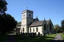
| Church | Place | Listed building Class |
|---|---|---|
| St Michael | Betchworth | I [9] |
| St Nicolas | Bookham | I[10] |
| St Nicholas | Charlwood | I[11] |
| St Michael | Mickleham | I [12] |
| St John the Evangelist | Wotton | I [13] |
| St Mary & St Nicholas | Leatherhead | II*[14] |
| St Barnabas | Ranmore Common | II* [15] |
| St Mary | Pixham | II* [16] |
| St Martin | Dorking | II* [17] |
| St Mary | Fetcham | II* [18] |
| St Giles | Ashtead | II* [19] |
| St James | Abinger Common | II* [20] |
| Holy Trinity | Westcott | II* [21] |
| St Bartholomew | Leigh | II* [22] |
| St Margaret | Ockley | II* [23] |
| St John the Baptist | Walliswood | II* [24] |
Environmental concerns
In May 2006, a report commissioned by British Gas [25] showed that housing in Mole Valley produced the twentieth highest average carbon emissions in the country at 6,928 kg of carbon dioxide per dwelling.
In 2008 a group of residents got together and formed The Green Mole Forum with the aim of promoting sustainable development in Mole Valley both by providing a hub to help residents, and to lobby the council to undertake more sustainable policies.
Emergency services
Mole Valley is served by these emergency services:
- Surrey Police. Dorking Police Station is the lead station in Mole Valley Division, Leatherhead Police Station is now closed.
- South East Coast Ambulance Service The district has two Ambulance Stations – one in North Holmwood (1 mile (2 km) south of Dorking), and the other in Leatherhead.
- Surrey Fire & Rescue Service, The district has two Fire Stations one in North Holmwood and the other in Leatherhead.
- SURSAR, The district is covered by Surrey Search & Rescue
- Hospital, Each town has a small NHS Hospital with no A&E. They are used for outpatients and rehabilitation.
Sources
- Local elections, 1999
- Local elections, 2000
- Local elections, 2002
- Local elections, 2003
- Local elections, 2004
See also
References
- ↑ "Government information about visitor attractions at Denbie's". Surrey County Council. Retrieved 5 May 2012.
- ↑ Surrey County Council website
- ↑ "Home Page". Abinger Parish Council. Retrieved 5 May 2012.
- ↑ Mole Valley District Council, 2012 Election Results
- ↑ BBC news
- ↑ Surrey County Councillors. Retrieved 2012-04-28
- ↑ "Cllr Helyn Clack". Surrey County Council. Retrieved 15 July 2016.
- ↑ Emily Chan, Jessica Duncan, It's wonderful in Waverley but hell in Hull! League table of most prosperous places to live show it's grim up north - but how does your town rate? in Daily Mail online dated 22 October 2016, accessed 22 October 2016
- ↑ Historic England. "Details from listed building database (1378131)". National Heritage List for England.
- ↑ Historic England. "Details from listed building database (1028641)". National Heritage List for England.
- ↑ Historic England. "Details from listed building database (1248610)". National Heritage List for England. Retrieved 15 March 2012.
- ↑ Historic England. "Details from listed building database (1028835)". National Heritage List for England.
- ↑ Historic England. "Details from listed building database (1294098)". National Heritage List for England.
- ↑ Historic England. "Details from listed building database (1190429)". National Heritage List for England.
- ↑ Historic England. "Details from listed building database (1189879)". National Heritage List for England.
- ↑ Historic England. "Details from listed building database (1279086)". National Heritage List for England.
- ↑ Historic England. "Details from listed building database (1028904)". National Heritage List for England.
- ↑ Historic England. "Details from listed building database (1378187)". National Heritage List for England.
- ↑ Historic England. "Details from listed building database (1028685)". National Heritage List for England.
- ↑ Historic England. "Details from listed building database (1378082)". National Heritage List for England.
- ↑ Historic England. "Details from listed building database (1227892)". National Heritage List for England.
- ↑ Historic England. "Details from listed building database (1028748)". National Heritage List for England.
- ↑ Historic England. "Details from listed building database (1028694)". National Heritage List for England.
- ↑ Historic England. "Details from listed building database (1028844)". National Heritage List for England.
- ↑ Centrica plc Archived 26 June 2008 at the Wayback Machine.. Britishgasnews.co.uk (2013-02-27). Retrieved on 2013-07-17.
External links

Coordinates: 51°18′57.68″N 0°29′37.31″W / 51.3160222°N 0.4936972°W