Ritten
| Ritten | |
|---|---|
| Comune | |
| Gemeinde Ritten Comune di Renon | |
|
The village of Unterinn in Ritten | |
 Ritten Location of Ritten in Italy | |
| Coordinates: 46°32′N 11°27′E / 46.533°N 11.450°ECoordinates: 46°32′N 11°27′E / 46.533°N 11.450°E | |
| Country | Italy |
| Region | Trentino-Alto Adige/Südtirol |
| Province / Metropolitan city | South Tyrol (BZ) |
| Frazioni | Oberinn (Auna di Sopra), Unterinn (Auna di Sotto), Atzwang (Campodazzo), Klobenstein (Collalbo), Lengmoos (Longomoso), Lengstein (Longostagno), Gissmann (Madonnina), Mittelberg (Monte di Mezzo), Rotwand (Pietrarossa), Oberbozen (Soprabolzano), Signat (Signato), Sill, Wangen (Vanga) |
| Government | |
| • Mayor | Paul Lintner |
| Area | |
| • Total | 111 km2 (43 sq mi) |
| Elevation | 1,154 m (3,786 ft) |
| Population (Nov. 2010) | |
| • Total | 7,597 |
| • Density | 68/km2 (180/sq mi) |
| Demonym(s) |
German: Rittner Italian: renonesi |
| Time zone | CET (UTC+1) |
| • Summer (DST) | CEST (UTC+2) |
| Postal code | 39054 |
| Dialing code | 0471 |
| Website | Official website |

Ritten (German pronunciation: [ˈrɪtn̩]; Italian: Renon [reˈnon]) is a comune (municipality) in South Tyrol in northern Italy.
Territory
The 111-square-kilometre (43 sq mi) community is named after the high plateau, elevation 1,100 to 1,400 metres (3,600 to 4,600 ft), the Ritten or the Renon, on which most of the villages are located. The plateau forms the southeast tip of the Sarntal Alps mountain range and is located between, and on average 800 metres (2,600 ft) above the rivers Eisack and Talfer. Ritten lies directly northeast of Bolzano, settled on the "meeting point" of the above rivers.
Ritten borders the following municipalities: Barbian, Bolzano, Kastelruth, Karneid, Völs, Jenesien, Sarntal and Villanders.
As of 30 November 2010, Ritten had a population of 7,597.[1]
There are 17 fraziones (subdivisions, usually consisting of one or a few villages and hamlets). These include the central village Klobenstein (Collalbo), in which the townhall is located, as well as Atzwang (Campodazzo), Gissmann (Madonnina), Lengmoos (Longomoso), Lengstein (Longostagno), Mittelberg (Monte di Mezzo), Oberbozen (Soprabolzano), Oberinn (Auna di Sopra), Rotwand (Pietrarossa), Siffian (Siffiano), Signat (Signato), Sill (Castel Novale), Unterinn (Auna di Sotto), Wangen (Vanga), and Wolfsgruben (Costalovara).
Of these only Atzwang and Sill are not located on the plateau, but on the rivers Eisack and Talfer, respectively.
History
The mountain ridge is first mentioned in AD 870 as "Mons Ritanus". Already around 1200 a mountain inn was established on the plateau. In 1237 Runkelstein Castle was built on a rocky spur in Ritten territory by the lords of Wangen.
The Tyrolean patriotic hero Peter Mayr (1767–1810), involved in the rebellion against Napoleon's forces that occupied Tyrol, was born in the village of Siffian in Ritten.
From the 17th century Ritten has been a popular summer destination for citizens of Bolzano, since the air is considerably cooler on the plateau. Ritten is connected with Bolzano with a provincial road and with a cableway from Oberbozen, the longest cableway of the world in one track, about 4 kilometres (2.5 mi) long and 12 minutes to travel. This cableway replaced in 1960 the previous rack railway, built in 1907. The railway is still in function on the mountain side between Maria Himmelfahrt and Klobenstein.
Coat of arms
The official community coat of arms consists of gules two chevrons embowed argent; it is the arms of the Lords of Zwingenstein who ruled the village from their castle until 1531. The emblem was adopted in 1967.[2]
Main sights
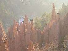
- Near Oberbozen and Lengstein are several groups of fairy chimneys (earth pyramids).
- Klobenstein has a 1,198-metre (3,930 ft) high-elevation outdoor artificial ice track, the Arena Ritten or Ritten Kunsteisbahn, at which the 2007 and 2011 European Allround Speed Skating Championships and many World Cup events have been held.
Economy
The candy company Loacker is based in Ritten.
Society
Linguistic distribution
According to the 2011 census, 95.20% of the population speak German, 4.55% Italian and 0.25% Ladin as first language.[3]
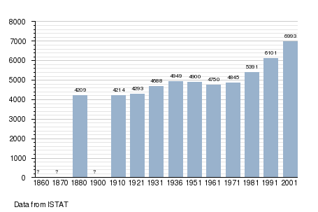
Demographic evolution
.png)
References
- ↑ South Tyrol in figures 2008 by the Provincial Statistics Institute ASTAT, part of Istat.
- ↑ Heraldry of the World: Ritten
- ↑ "Volkszählung 2011/Censimento della popolazione 2011". astat info. Provincial Statistics Institute of the Autonomous Province of South Tyrol (38): 6–7. June 2012. Retrieved 2012-06-14.
External links
![]() Media related to Ritten at Wikimedia Commons
Media related to Ritten at Wikimedia Commons
- (German) (Italian) Homepage of the municipality