Stilfs
| Stilfs | ||
|---|---|---|
| Comune | ||
| Gemeinde Stilfs Comune di Stelvio | ||
|
Stilfs | ||
| ||
 Stilfs Location of Stilfs in Italy | ||
| Coordinates: 46°36′N 10°33′E / 46.600°N 10.550°ECoordinates: 46°36′N 10°33′E / 46.600°N 10.550°E | ||
| Country | Italy | |
| Region | Trentino-Alto Adige/Südtirol | |
| Province / Metropolitan city | South Tyrol (BZ) | |
| Frazioni | Sulden (Solda) | |
| Government | ||
| • Mayor | Hartwig Tschenett | |
| Area | ||
| • Total | 140 km2 (50 sq mi) | |
| Elevation | 1,311 m (4,301 ft) | |
| Population (Nov. 2010) | ||
| • Total | 1,215 | |
| • Density | 8.7/km2 (22/sq mi) | |
| Demonym(s) | German: Stilfser | |
| Time zone | CET (UTC+1) | |
| • Summer (DST) | CEST (UTC+2) | |
| Postal code | 39029 | |
| Dialing code | 0473 | |
| Website | Official website | |

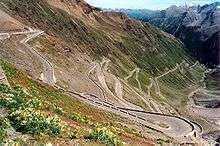
Part of the famous Stelvio Pass
Stilfs (German pronunciation: [ʃtɪlfs]; Italian: Stelvio [ˈstɛlvjo]) is a comune (municipality) in the province of South Tyrol in northern Italy. It is located near the northern ramp of the Stelvio Pass.
The municipality of Stilfs contains the frazioni (subdivisions, mainly villages and hamlets) Sulden (Solda), Trafoi, Gomagoi.
History
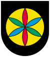
Coat-of-arms
The emblem shows an or disc on sable background; inside the disc is a six leaves star of azure, vert and gules alternating. The star symbolize an ancient nightly custom in winter time. The emblem was granted in 1969.[1]
Society
Linguistic distribution
According to the 2011 census, 98.46% of the population speak German and 1.54% Italian as first language.[2]
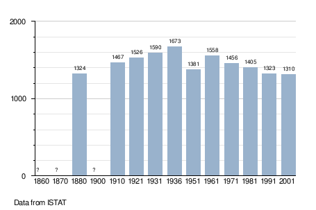
Demographic evolution
See also
References
- ↑ Heraldry of the World: Stilfs
- ↑ "Volkszählung 2011/Censimento della popolazione 2011". astat info. Provincial Statistics Institute of the Autonomous Province of South Tyrol (38): 6–7. June 2012. Retrieved 2012-06-14.
External links
- (German) (Italian) Homepage of the municipality
![]() Media related to Stilfs at Wikimedia Commons
Media related to Stilfs at Wikimedia Commons
This article is issued from Wikipedia - version of the 4/29/2016. The text is available under the Creative Commons Attribution/Share Alike but additional terms may apply for the media files.