Sand in Taufers
| Sand in Taufers | ||
|---|---|---|
| Comune | ||
| Marktgemeinde Sand in Taufers Comune mercato di Campo Tures | ||
|
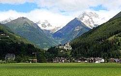
Town centre with Taufers Castle | ||
| ||
 Sand in Taufers Location of Sand in Taufers in Italy | ||
| Coordinates: 46°55′16″N 11°57′20″E / 46.92111°N 11.95556°ECoordinates: 46°55′16″N 11°57′20″E / 46.92111°N 11.95556°E | ||
| Country | Italy | |
| Region | Trentino-Alto Adige/Südtirol | |
| Province / Metropolitan city | South Tyrol (BZ) | |
| Frazioni | Ahornach (Acereto), Kematen (Caminata di Tures), Mühlen in Taufers (Molini di Tures), Rein in Taufers (Riva di Tures) | |
| Government | ||
| • Mayor | Sigfried Steinmair | |
| Area | ||
| • Total | 164.3 km2 (63.4 sq mi) | |
| Elevation | 864 m (2,835 ft) | |
| Population (Nov. 2010) | ||
| • Total | 5,261 | |
| • Density | 32/km2 (83/sq mi) | |
| Demonym(s) |
German: Sandner Italian: di Campo Tures | |
| Time zone | CET (UTC+1) | |
| • Summer (DST) | CEST (UTC+2) | |
| Postal code | 39032 | |
| Dialing code | 0474 | |
| Website | Official website | |

Sand in Taufers (German pronunciation: [sant ɪn ˈtaʊ̯fɐs]; Italian: Campo Tures [ˈkampo ˈtuːres]) is a comune mercato (market town) in South Tyrol in northern Italy.
Geography
Located about 70 kilometres (43 mi) northeast of Bolzano, the town centre is situated in the Tauferer Ahrntal (Taufers) valley of the Ahr river, stretching from Bruneck in Pustertal up northwards to the Venediger Group mountains of the Hohe Tauern range and the border with Austria. The municipal are comprises the frazioni of Ahornach, Kematen, Mühlen in Taufers, and Rein in Taufers. As of 30 November 2010, Sand in Taufers had a population of 5,261 and an area of 164.3 square kilometres (63.4 sq mi).[1]

The market town borders the Tauferer Ahrntal municipalities of Gais in the south as well as Ahrntal and Prettau further north. In the east, the municipal area comprises the Reinbach gorge and the slopes of the Rieserferner Group. Large parts are covered by the Rieserferner-Ahrn Nature Park, a protected nature reserve which extends to neighbouring Percha, Rasen-Antholz and Sankt Jakob in Defereggen in Austrian East Tyrol. West of the village of Mühlen, the Mühlwald valley stretches westwards up along the Speikboden massif to the Neves reservoir and the crest of the Zillertal Alps.
The local Taufers Railway connection from Bruneck station to Sand in Taufers, built in 1908, was discontinued in 1957. Today, the region largely depends on tourism.
Taufers Castle
The settlement of Tvfres was first mentioned in the mid 11th century in the registers of the Prince-bishops of Brixen. The Tyrolean lordship was ruled from Taufers Castle, a huge medieval fortress which towers on a rock above the village and was built from the early 13th century onwards.[2] Restored in the 20th century, the preserved castle complex is a popular film location, providing the setting of the 1998 drama film The Red Violin and the 2003 comedy Just Married. It also served as a picturesque backdrop for Roman Polanski's 1967 horror classic The Fearless Vampire Killers.
Demography
Linguistic distribution
According to the 2011 census, 97.34% of the population speak German, 2.30% Italian and 0.36% Ladin as first language.[3]
Demographic evolution

Coat-of-arms
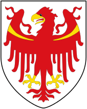
The arms is barry of six gules and argent. The first two of argent have three lozenge of azure, the third has two. The emblem was of the Lords of Taufers that became extinct in 1300. The emblem was adopted in 1967.[4]
Notable people
- Hans Kammerlander (born 1956), mountaineer.
Notes
- ↑ All demographics and other statistics: Italian statistical institute Istat.
- ↑ "Taufers Castle History (German)".
- ↑ "Volkszählung 2011/Censimento della popolazione 2011". astat info. Provincial Statistics Institute of the Autonomous Province of South Tyrol (38): 6–7. June 2012. Retrieved 2012-06-14.
- ↑ Heraldry of the World: Sand in Taufers
References
- Josef Innerhofer: Taufers, Ahrn, Prettau. Die Geschichte eines Tales, Bozen: Verlagsanstalt Athesia 1980, ISBN 978-3-921365-06-9.
- Alexander von Hohenbühel: Taufers - eine Dynastenburg, Regensburg: Schnell & Steiner 2007, ISBN 978-3-7954-1836-6.
- Idem: Taufers - il fascino di un castello dinastiale, Regensburg: Schnell & Steiner 2007, ISBN 978-3-7954-1837-3.
External links
| Wikimedia Commons has media related to Sand in Taufers. |
- (German) (Italian) Homepage of the municipality