Kurtinig an der Weinstraße
| Kurtinig | |
|---|---|
| Comune | |
| Gemeinde Kurtinig an der Weinstraße Comune di Cortina sulla Strada del Vino | |
 Kurtinig Location of Kurtinig in Italy | |
| Coordinates: 46°16′N 11°13′E / 46.267°N 11.217°ECoordinates: 46°16′N 11°13′E / 46.267°N 11.217°E | |
| Country | Italy |
| Region | Trentino-Alto Adige/Südtirol |
| Province / Metropolitan city | South Tyrol (BZ) |
| Government | |
| • Mayor | Manfred Mayr (South Tyrolean People's Party) |
| Area | |
| • Total | 2.0 km2 (0.8 sq mi) |
| Population (Nov.2010) | |
| • Total | 646 |
| • Density | 320/km2 (840/sq mi) |
| Demonym(s) |
German:Kurtiniger Italian: cortineri |
| Time zone | CET (UTC+1) |
| • Summer (DST) | CEST (UTC+2) |
| Postal code | 39040 |
| Dialing code | 0471 |
| Website | Official website |
Kurtinig an der Weinstraße (German pronunciation: [kʊrˈtinɪk an dɐ ˈvaɪ̯nˌʃtraˑsə]; Italian: Cortina sulla Strada del Vino [korˈtiːna ˈsulla ˈstraːda del ˈviːno]), often abbreviated to Kurtinig or Cortina, is a comune (municipality) in South Tyrol in northern Italy, located about 30 kilometres (19 mi) southwest of the city of Bolzano.
As of 30 November 2010, it had a population of 646 and an area of 2.0 square kilometres (0.77 sq mi).[1]
Kurtinig borders the following municipalities: Margreid, Neumarkt, and Salorno.
History
Coat-of-arms
The emblem is an argent embattled wall, with a portal, above an azure band in the lower half; an eight-pointed star on the left side and the crescent moon on the right, both of argent on a gules background, in the upper half. The embattlted wall was built to protect the village from the flooding of the river Etsch; the star and the moon are a recall to the arms of the Lords of Appian which the village belonged.[2]
Society
Linguistic distribution
According to the 2011 census, 68.67% of the population speak German, 31.15% Italian and 0.17% Ladin as first language.[3]
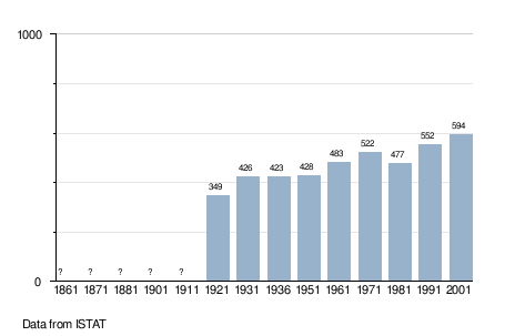
Demographic evolution
References
- ↑ All demographics and other statistics: Italian statistical institute Istat.
- ↑ Heraldry of the World: Kurtinig
- ↑ "Volkszählung 2011/Censimento della popolazione 2011". astat info. Provincial Statistics Institute of the Autonomous Province of South Tyrol (38): 6–7. June 2012. Retrieved 2012-06-14.
External links
- (German) (Italian) Homepage of the municipality
![]() Media related to Kurtinig an der Weinstraße at Wikimedia Commons
Media related to Kurtinig an der Weinstraße at Wikimedia Commons